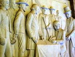
Sand River Convention
|
As depicted in the Voortrekker Monument | |
| Type | Delimitation of territory and rights |
|---|---|
| Signed | 17 January 1852 |
| Location | Bank of the Sand River, South Africa |
| Effective | 17 January 1852 |
| Signatories | Andries Pretorius for the Boers and William Hogge and Mostyn Owen for Great Britain |
| Language | English |
|
| |
The Sand River Convention was a convention whereby Great Britain formally recognised the independence of the South African Republic.[1]
Provisions
The treaty contained the following provisions:
- That the British government guarantees and grants the emigrant farmers across the Vaal river the right to govern themselves, according to their own laws free from any and all British interference and that the British Government wishes to promote peace, free trade and friendly intercourse with the new country.
- That Britain disclaims any and all alliances with coloured nations to the North of the Vaal river
- That no slavery be practised in the country to the North of the Vaal river
- Ammunition and Arms crossing over the border from the South of the Vaal river shall require a certificate from a British Magistrate and that no arms or munitions be supplied to the natives by either the British or by the people of the new country.
- It is agreed that criminals will be exchanged between the British and the new country and that summonses for witnesses from both sides of the river be backed up by the magistrates at both sides of the river.
- It is agreed that certificates of marriages will be recognised on both sides of the river
- It is agreed that any and all people now residing in British land but being in possession of land in the new country shall have the free right to sell the property and to move freely over the Vaal river.
The convention was signed on 17 January 1852 by Commandant-General Andries Pretorius and others, on behalf of the new country, and Major William Hogge and Mostyn Owen, clerk to the Civil Commissioner of Winburg, duly authorised to, and on behalf of, the British government. The treaty was signed on the farm called Sand River belonging to P.A. Venter, near Ventersburg.
Claims of contraventions of the treaty

The ZAR claimed that the British contravened the treaty in 1853, with an English citizen, the missionary Livingstone supplying, storing and causing repairs to materials of war to the native tribes. Commandant Scholtz and his men confiscated a large amount of rifles, ammunition and equipment from the home of Livingstone.[2] The British in turn claimed that the Boers were keeping slaves, in reference to the legal practise of "ingeboekt" placement by native orphans in Boer homes, under supervision of the legal system, only until they became of age (16 years old). The Boers responded that the acts of a few criminals and criminal gangs cannot be claimed to be that of an entire nation.
First Boer War
One of the causes of the First Boer War was the direct breach by the British of this convention on 12 April 1877. Britain issued a proclamation called: "ANNEXATION OF THE S.A. REPUBLIC TO THE BRITISH EMPIRE"[1]:448–449 and proceeded to occupy Pretoria. Although the British did not attempt to dismantle the country, and self-rule was decreed in the proclamation, the annexation was not accepted by the ZAR and a delegation was sent to Europe and the USA to protest this action.
See also
References
- 1 2 Eybers (1917). Select_constitutional_documents_illustrating_South_African_history_1795-1910. pp. 357–359.
- ↑ Kruger, Paul (1902). Memoirs of Paul Kruger. Canada: George R Morang and Co. p. 40.
Coordinates: 28°13′55″S 27°05′21″E / 28.23194°S 27.08917°E
