Rosenstein (Swabian Jura)
| Rosenstein | |
|---|---|
|
Rosenstein Mountain | |
| Highest point | |
| Elevation | 735 m (2,411 ft) |
| Coordinates | 48°47′47″N 9°57′37″E / 48.79639°N 9.96028°ECoordinates: 48°47′47″N 9°57′37″E / 48.79639°N 9.96028°E |
| Geography | |
 Rosenstein The location within Baden-Württemberg | |
| Location | Baden-Wuerttemberg, Germany |
| Parent range | Swabian Jura |
The Rosenstein is a 735 m high mountain in the Swabian Jura (German: Schwäbische Alb) above the town of Heubach near Schwäbisch Gmünd, Germany.
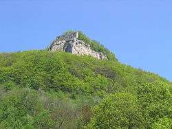
With its exposed position as head of the Alb it had been of strategic importance. Excavations in the caves on Rosenstein have found tools dating back to the Paleolithic period. Among the best-known caves are scouring the "Great" and "Dark hole". About the Western rock, the remnants of a medieval castle, Rosenstein castle ruins.
The Rosenstein is now a very popular recreational area, especially for climbers and mountain bikers.
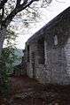 Rosenstein Ruins
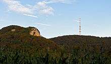 Rosenstein Ruins and Telecommunication Tower
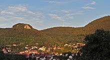 Rosenstein Ruins above Heubach
See also
External links
This article is issued from Wikipedia - version of the 11/15/2016. The text is available under the Creative Commons Attribution/Share Alike but additional terms may apply for the media files.