Rockhill, Pennsylvania
| Rockhill, Pennsylvania | |
|---|---|
| Borough | |
|
| |
 Rockhill, Pennsylvania | |
| Coordinates: 40°14′35″N 77°54′02″W / 40.24306°N 77.90056°WCoordinates: 40°14′35″N 77°54′02″W / 40.24306°N 77.90056°W | |
| Country | United States |
| State | Pennsylvania |
| County | Huntingdon |
| Government | |
| • Type | Borough Council |
| • Mayor | Karl Barry (R) |
| Area | |
| • Total | 0.3 sq mi (0.8 km2) |
| Population (2000) | |
| • Total | 414 |
| • Density | 1,323.8/sq mi (511.1/km2) |
| Time zone | Eastern (EST) (UTC-5) |
| • Summer (DST) | EDT (UTC-4) |
| Zip code | 17249 |
| Area code(s) | 814 |
| School District: | Southern Huntingdon County School District |
| Local phone exchanges: 447, 448 | |
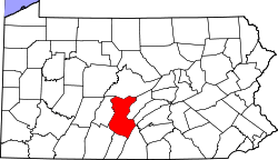
Rockhill or Rockhill Furnace is a borough in Huntingdon County, Pennsylvania, United States.[1] The population was 414 at the 2000 census. It is the site of the East Broad Top Railroad.
Although the community was long known as "Rockhill Furnace," its name has always officially been "Rockhill."[2]
Geography
Rockhill is located at 40°14′35″N 77°54′2″W / 40.24306°N 77.90056°W (40.242927, -77.900433).[3]
According to the United States Census Bureau, the borough has a total area of 0.3 square miles (0.78 km2), all of it land.
Demographics
| Historical population | |||
|---|---|---|---|
| Census | Pop. | %± | |
| 1890 | 657 | — | |
| 1900 | 495 | −24.7% | |
| 1910 | 504 | 1.8% | |
| 1920 | 500 | −0.8% | |
| 1930 | 502 | 0.4% | |
| 1940 | 548 | 9.2% | |
| 1950 | 567 | 3.5% | |
| 1960 | 566 | −0.2% | |
| 1970 | 480 | −15.2% | |
| 1980 | 472 | −1.7% | |
| 1990 | 421 | −10.8% | |
| 2000 | 414 | −1.7% | |
| 2010 | 371 | −10.4% | |
| Est. 2015 | 361 | [4] | −2.7% |
| Sources:[5][6][7] | |||
As of the census[6] of 2000, there were 414 people, 173 households, and 119 families residing in the borough. The population density was 1,323.8 people per square mile (515.6/km²). There were 186 housing units at an average density of 594.7 per square mile (231.7/km²). The racial makeup of the borough was 99.28% White, 0.72% from other races. Hispanic or Latino of any race were 2.42% of the population.
There were 173 households, out of which 27.7% had children under the age of 18 living with them, 55.5% were married couples living together, 10.4% had a female householder with no husband present, and 31.2% were non-families. 27.2% of all households were made up of individuals, and 13.3% had someone living alone who was 65 years of age or older. The average household size was 2.39 and the average family size was 2.90.
In the borough the population was spread out, with 23.7% under the age of 18, 6.0% from 18 to 24, 28.7% from 25 to 44, 23.7% from 45 to 64, and 17.9% who were 65 years of age or older. The median age was 41 years. For every 100 females there were 84.8 males. For every 100 females age 18 and over, there were 82.7 males.
The median income for a household in the borough was $27,639, and the median income for a family was $36,250. Males had a median income of $31,125 versus $20,375 for females. The per capita income for the borough was $15,376. About 9.4% of families and 13.8% of the population were below the poverty line, including 14.0% of those under age 18 and 21.3% of those age 65 or over.
History
The narrow gauge East Broad Top Railroad was constructed through the community in 1873. Rockhill was selected as the location of the railroad's maintenance facility. The parent company Rockhill Iron and Coal, located their dual-stack coke fired iron furnace here. Rockhill as it exists today was created by the coal company and the railroad as a support community for their infrastructure.
The iron furnace shut down for the last time in 1907 and the railroad became the primary employer. The EBT shut down in 1956 but a portion from Rockhill north to Shirleysburg was reactivated in 1960 as a tourist operation. In the late 2000s the track to the south was rehabilitated to PA 475 sufficiently for speeders to operate and give rides to the public.
Points of interest
References
- ↑ U.S. Geological Survey Geographic Names Information System: Rockhill, Pennsylvania
- ↑ Population Estimates Boundary Changes, United States Census Bureau, 2009-03-18. Accessed 2009-07-23.
- ↑ "US Gazetteer files: 2010, 2000, and 1990". United States Census Bureau. 2011-02-12. Retrieved 2011-04-23.
- ↑ "Annual Estimates of the Resident Population for Incorporated Places: April 1, 2010 to July 1, 2015". Retrieved July 2, 2016.
- ↑ "Census of Population and Housing". U.S. Census Bureau. Archived from the original on 11 May 2015. Retrieved 11 December 2013.
- 1 2 "American FactFinder". United States Census Bureau. Archived from the original on 2013-09-11. Retrieved 2008-01-31.
- ↑ "Incorporated Places and Minor Civil Divisions Datasets: Subcounty Resident Population Estimates: April 1, 2010 to July 1, 2012". Population Estimates. U.S. Census Bureau. Archived from the original on 17 June 2013. Retrieved 11 December 2013.

