Rockefeller Township, Northumberland County, Pennsylvania
| Rockefeller Township, Pennsylvania | |
|---|---|
| Township | |
|
Scenery in Rockefeller Township | |
|
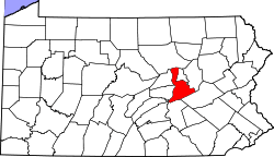
Map of Northumberland County, Pennsylvania highlighting Rockefeller Township | |
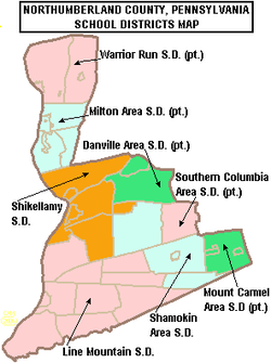
 Map of Northumberland County, Pennsylvania | |
| Country | United States |
| State | Pennsylvania |
| County | Northumberland |
| Settled | 1774 |
| Incorporated | 1880 |
| Government | |
| • Type | Board of Supervisors |
| Area | |
| • Total | 20.6 sq mi (53.4 km2) |
| Population (2010) | |
| • Total | 2,273 |
| • Density | 110.3/sq mi (42.6/km2) |
| Time zone | Eastern (EST) (UTC-5) |
| • Summer (DST) | EDT (UTC-4) |
| Area code(s) | 570 |
Rockefeller Township is a township in Northumberland County, Pennsylvania, United States. The population at the 2010 Census was 2,273,[1] up from 2,221 at the 2000 census.
History
The Zion Stone Church was listed on the National Register of Historic Places in October 6th 1984.[2]
Geography
According to the United States Census Bureau, the township has a total area of 20.6 square miles (53.4 km²), all of it land.
Demographics
As of the census[3] of 2000, there were 2,221 people, 836 households, and 681 families residing in the township. The population density was 107.6 people per square mile (41.6/km²). There were 868 housing units at an average density of 42.1/sq mi (16.2/km²). The racial makeup of the township was 99.19% White, 0.05% African American, 0.14% Native American, 0.09% Asian, 0.23% from other races, and 0.32% from two or more races. Hispanic or Latino of any race were 0.23% of the population.
There were 836 households out of which 31.8% had children under the age of 18 living with them, 73.3% were married couples living together, 5.6% had a female householder with no husband present, and 18.5% were non-families. 14.7% of all households were made up of individuals and 6.9% had someone living alone who was 65 years of age or older. The average household size was 2.66 and the average family size was 2.94.
In the township the population was spread out with 22.8% under the age of 18, 5.9% from 18 to 24, 30.1% from 25 to 44, 28.0% from 45 to 64, and 13.2% who were 65 years of age or older. The median age was 41 years. For every 100 females there were 99.6 males. For every 100 females age 18 and over, there were 97.9 males.
The median income for a household in the township was $42,212, and the median income for a family was $47,800. Males had a median income of $34,063 versus $21,969 for females. The per capita income for the township was $19,004. About 8.1% of families and 8.8% of the population were below the poverty line, including 12.5% of those under age 18 and 7.0% of those age 65 or over.
Education

The local public school system is the Shikellamy School District. The administrative offices are located at Administration Center, 200 Island Blvd, Sunbury, Pennsylvania. Shikellamy High School has a 78% graduation rate according to the district report card 2005-2006. In 11th grade, 49% were proficient in math. For reading 62% were proficient in 2005-2006. The high school is ranked 384th out of 606 public high schools in Pennsylvania.
In 2007, the Pittsburgh Business Times ranked the Shikellamy School District 434th out of 499 Pennsylvania school districts based on three years of Pennsylvania System of Student Assessment test scores.[4]
The Shikellamy School Board set the budget at $34.62 million for 2007-2008. The board levies a variety of taxes to support its programs. Taxes include 62.5 mills real estate tax in 2007.[5] Per capita taxes are $5 per resident. An earned income taxes of one-half of 1 percent of income yields a revenue of approximately $1.8 million. Additionally, the real estate transfer tax of one-half percent (Northumberland Borough, Point Township, Rockefeller Township) and one percent (Snydertown borough) is levied on real estate transfers.[6]
Voters rejected a tax referendum in May 2007 which would have increased local earned income tax by 0.5 percent to reduce property taxes for homeowners and farmers by $176.[7]
SUN Area Career & Technology Center is a regional vocational school, offering adult education classes, vocational education, and technical career training. SUN Tech serves over 1500 people annually. ISO9001 and Middle States Accredited. SUN Tech was presented with the Significant Achievement Award in Education for raising their Malcolm Baldrige National Quality Award score to 648 points, a 345-point increase from 303 points in August, 2000.
Residents also have a wide selection of alternative schools. By law, the local public school must provide transportation to schools within 10 miles of the borders of the school district at no charge to the student.[8]
Parochial schools
- St. Monica's School provides a parochial education program for kindergarten to 8th grades. The school is a member of the National Christian Schools Association. Noncatholics seek admission to this school.
- Sunbury Christian Academy offers pre-kindergarten through 12th grade. The campus is located just north of the borough of Northumberland. The student population is nearing 160. Programs and student accomplishments are noted regularly in local media.
- Northumberland Christian School was founded in 1972 and is a ministry of the First Regular Baptist Church of Northumberland, Pa. The school offers an educational program for students from preschool through high school.
Charter Public Schools
- Connections Academy provides a form of public school that students can attend from home. This is a unique program that combines strong parental involvement, the expertise and accountability of publicly funded education, and the flexibility of online classes. Centered on meeting students needs and goals. Has a K-11th program. Students are required to take all state mandated, standardized tests in person at locations designated by the school.[9]
- SusQ-Cyber Charter School provides students in grades 9-12 with an electronically delivered accredited high school curriculum.
- 21st Century Cyber Charter School is a state accredited, diploma granting school serving Pennsylvania students in grades 6 through 12. Modifications are made to suit individual student learning styles, varying academic levels and scheduling needs. Most classes are offered in honors, college prep, and career paths. All of the classes are designed to prepare the student for standardized tests such as the PSSAs.
- Pennsylvania Virtual Charter School provides a structured yet flexible, interactive environment in a program for Kindergarten through 10th grade. The rigorous instruction, high standards, informed guidance, and individual attention provide each student with the opportunity to be highly successful. Teachers interact with students via email. Additionally the Elluminate classroom gives the student access to their teachers during the teacher’s office hours to ask questions related to content of a subject. "An independent audit of cyber-charter schools by KPMG Consulting, which was commissioned by the Pennsylvania Department of Education, praised PAVCS for offering a well-researched program and an appropriate assessment plan."[10]
References
- ↑ "Geographic Identifiers: 2010 Demographic Profile Data (G001): Rockefeller Township, Northumberland County, Pennsylvania". U.S. Census Bureau, American Factfinder. Retrieved Aug 22, 2016.
- ↑ National Park Service (2010-07-09). "National Register Information System". National Register of Historic Places. National Park Service.
- ↑ "American FactFinder". United States Census Bureau. Retrieved 2008-01-31.
- ↑ Valley schools all over the chart, Daily Item June 6, 2007 http://www.dailyitem.com/archivesearch/local_story_163000144.html
- ↑ Shikellamy school board adopts $34.6M budget, Daily Item, June 20, 2007 http://www.dailyitem.com/0100_news/local_story_171003120.html
- ↑ Shikellamy budget approved Daily Item, May 19, 2007 http://www.dailyitem.com/archivesearch/local_story_139001649.html
- ↑ Tax reform proposal falls in all Valley school districts, Daily Item, May 19, 2007. http://www.dailyitem.com/archivesearch/local_story_139203055.html
- ↑ 24 PS 17-1726-A Transportation to charter schools http://www.pde.state.pa.us/transportation/lib/transportation/SchoolCode_Transportation_7-17-06.pdf
- ↑ http://www.connectionsacademy.com/state/home.asp?schoolCode=CCA Connections Academy
- ↑ Boss, Shira, "Virtual charters: public schooling, at home", Christian Science Monitor, January 2002.
Coordinates: 40°50′00″N 76°45′29″W / 40.83333°N 76.75806°W