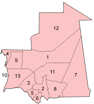
Regions of Mauritania
 |
| This article is part of a series on the politics and government of Mauritania |
Mauritania is divided into 15 regions:

 | |||||
| Map key | Province | Native name | Capital | Area | Population (2013) |
|---|---|---|---|---|---|
| 1 | Adrar | أدرار | Atar | 235,000 km2 (91,000 sq mi) | 62,658 |
| 2 | Assaba | لعصابة | Kiffa | 36,600 km2 (14,100 sq mi) | 325,897 |
| 3 | Brakna | لبراكنة | Aleg | 33,000 km2 (13,000 sq mi) | 312,277 |
| 4 | Dakhlet Nouadhibou | داخلة نواذيبو | Nouadhibou | 23,090 km2 (8,920 sq mi) | 123,779 |
| 5 | Gorgol | كوركول | Kaédi | 13,600 km2 (5,300 sq mi) | 335,917 |
| 6 | Guidimaka | غيديماغا | Sélibaby | 10,300 km2 (4,000 sq mi) | 267,029 |
| 7 | Hodh Ech Chargui | الحوض الشرقي | Néma | 182,700 km2 (70,500 sq mi) | 430,668 |
| 8 | Hodh El Gharbi | الحوض الغربي | Ayoun el Atrous | 53,400 km2 (20,600 sq mi) | 294,109 |
| 9 | Inchiri | إينشيري | Akjoujt | 46,800 km2 (18,100 sq mi) | 19,639 |
| 10 | Nouakchott-Nord | نواكشوط الشمالية | Dar-Naim | 306 km2 (118 sq mi) | 366,912 |
| 10 | Nouakchott-Ouest | نواكشوط الغربية | Tevragh-Zeina | 146 km2 (56 sq mi) | 165,814 |
| 10 | Nouakchott-Sud | نواكشوط الجنوبية | Arafat | 252 km2 (97 sq mi) | 425,673 |
| 11 | Tagant | تكانت | Tidjikja | 98,340 km2 (37,970 sq mi) | 80,962 |
| 12 | Tiris Zemmour | تيرس زمور | Zouérat | 252,900 km2 (97,600 sq mi) | 53,261 |
| 13 | Trarza | الترارزه | Rosso | 67,800 km2 (26,200 sq mi) | 272,773 |
During the Mauritanian occupation of Western Sahara (1975–79), its portion of the territory (roughly corresponding to the lower half of Río de Oro province) was named Tiris al-Gharbiyya.
The regions are subdivided into 44 departments; please see departments of Mauritania for further detail.
See also
This article is issued from Wikipedia - version of the 6/14/2015. The text is available under the Creative Commons Attribution/Share Alike but additional terms may apply for the media files.