Rattlesnake Hills
| Rattlesnake Hills | |
|---|---|
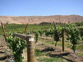
 Rattlesnake Hills behind a vineyard. | |
| Highest point | |
| Peak | Elephant Mountain |
| Elevation | 3,629 ft (1,106 m) |
| Geography | |
| Country | United States |
| State | Washington |
| County | Yakima and Benton |
| Range coordinates | 46°27′N 119°50′W / 46.45°N 119.83°WCoordinates: 46°27′N 119°50′W / 46.45°N 119.83°W |
The Rattlesnake Hills is a 16-mile (26 km) long anticline mountain ridge in Yakima County and Benton County in the U.S. state of Washington. Also known as Rattlesnake Mountain and Rattlesnake Ridge,[1] it should not be confused with the much smaller Rattlesnake Ridge located near the west end of Ahtanum Ridge.[2] Rattlesnake Hills' highest summit is 3,629 feet (1,106 m) tall, which is also the highest point in Benton County.[3] The Rattlesnake Hills are part of the Yakima Fold Belt of east-tending long ridges formed by the folding of Miocene Columbia River basalt flows.[4]
The Rattlesnake Hills form the northern edge of the Yakima Valley, running from the vicinity of Benton City to just south of the city of Yakima, where the Yakima River cuts through the mountain ridge via Union Gap. To the west of the Yakima River the mountain ridge is known as Ahtanum Ridge.
North of the Rattlesnake Hills is Moxee Valley and the Black Rock Valley. The hills extend into the Hanford Site. A spur on the north side of the ridge nearly connects with the west end of Yakima Ridge.
Roza Canal, used for agricultural irrigation, passes under the Rattlesnake Hills through a tunnel.
Named high points of the Rattlesnake Hills, according to the USGS, include Elephant Mountain, Zillah Peak, Eagle Peak, High Top, and, near the eastern end, Rattlesnake Mountain.