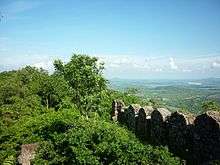
Ramagiri Fort
| Ramagiri Fort | |
|---|---|
| Peddapalli district, Telangana, India | |
|
View of Ramagiri Fort | |
 Ramagiri Fort | |
| Coordinates | 18°34′59″N 79°31′59″E / 18.583°N 79.533°E |
| Type | Fort |
| Site information | |
| Open to the public | Yes |
| Condition | Ruins |
| Site history | |
| Built | 12th century |
| Built by | Kakatiyas |
| Materials | Stone and mud |
The Ramagiri Fort, also known as Ramagiri Khilla, located over a mountain top, is in the Peddapalli district of the Indian state of Telangana.[1]
Location
The fort, located on the Ramagiri hills, is near the Begumpet village in RAMAGIRI mandal, in PEDDAPALLI District. The fort was built within a thickly forested area which has a wealth of plant species which includes many medicinal herbs.[2] The fort provides a scenic view of the confluence of the Manair and Godavari Rivers.[1]
The fort is 22 kilometres (14 mi) away from PEDDAPALLI, the district headquarters.[2] The Peddapalli – Manthani highway passes close to the fort, which is 2 kilometres (1.2 mi) away from the Begumpet village.[1]
History
The fort was built in the 12th century by the Kakatiyas of Warangal. Later, it was controlled by the Qutub Sahi Sultanate from 1518 to 1687. In 1656, the ruler of Golconda, Abdullah Qutb Shah, gave the fort to his son-in-law, one of Aurangzeb's sons.[3] The fort came under the control of the British Raj in 1791.[4] Tradition has it that Kalidasa, one of the greatest Sanskrit poets, was motivated to compose his Meghadūta, a lyrical poem, by the Ramagiri Fort; however, Kalidasa is thought to have lived in the fifth century CE, well before the fort's construction.[5]
Features

Built in stone, the fort has many bastions and occupies a large area of a few square kilometres.[2] The bastions are in octagonal shape.[6] The fort had been fitted with four forge-welded cannons on the masonry battlements which were built to a height of 12 metres (39 ft) as part of the fort walls.[3] It has been noted that the mud plaster which covered some of the structures in thick layers was a combination of mud, lime, reeds, hair of animals, or even blood of animals.[7]
Herbal plants
The Ramagiri forest in the area of the fort is an important source for medicinal plants. Large numbers of local medicinal people collect the plants and offer them for sale in nearby towns. Students also visit the area to identify these plants and make herbarium specimens. In view of this importance for medicinal plants, it has been suggested that the forest of the fort area be declared a Medicinal Plants Conservation Center.[8]
References
- 1 2 3 "Ramagiri Khilla". Telangana Tourism Government of Telangana. Retrieved 28 June 2015.
- 1 2 3 "Tourism lies in neglect". Deccan Chronicle. 26 September 2014.
- 1 2 Roy 2014, p. 116.
- ↑ Dictionary of British-Indian Dates: Being a Compendium of All the Dates Essential to the Study of the History of British Rule in India. W. Blackwood. 1866. p. 129.
- ↑ Congress 1990, p. 775.
- ↑ Murthy 1997, p. 32.
- ↑ Murthy 1997, p. 26.
- ↑ Murthy, E. Narasimha; Madhav, N. Venu (April 2015). "Enumeration of Medicinal Plants of Ramagiri-Khilla Forests of Karimnagar District, Telangana, India" (PDF). International Journal of Pharmacy and Life Sciences. 6 (4): 4405–4416. ISSN 0976-7126.
Bibliography
- Congress, Indian History (1990). Proceedings – Indian History Congress. p. 775.
- Murthy, K. Lakshmana (1997). Structural Conservation of Monuments in South India. Bhartiya Kala Prakashan. ISBN 978-81-86050-06-4.
- Roy, Kaushik (22 May 2014). Military Transition in Early Modern Asia, 1400–1750: Cavalry, Guns, Government and Ships. A&C Black. ISBN 978-1-78093-813-4.
