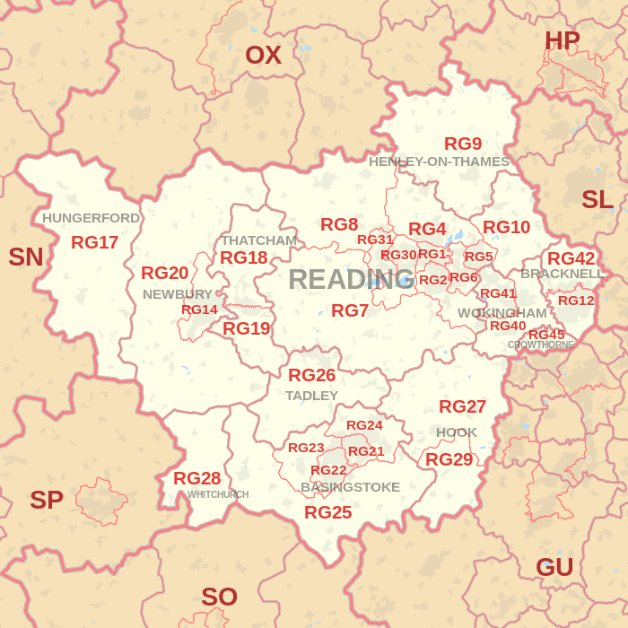
RG postcode area
Postcode district boundaries: Bing / Google
| Reading postcode area | |
|---|---|
 RG | |
| Postcode area | RG |
| Postcode area name | Reading |
| Post towns | 12 |
| Postcode districts | 35 |
| Postcode sectors | 184 |
| Postcodes (live) | 23,029 |
| Postcodes (total) | 43,999 |
| Statistics as at February 2012[1] | |
The RG postcode area, also known as the Reading postcode area,[2] is a group of thirty postcode districts in England, which are subdivisions of twelve post towns. These postcode districts cover west and central Berkshire (including Reading, Bracknell, Crowthorne, Hungerford, Newbury, Thatcham and Wokingham) and north Hampshire (including Basingstoke, Hook, Tadley and Whitchurch), plus a small part of south-east Oxfordshire (including Henley-on-Thames) and very small parts of Buckinghamshire and Wiltshire.
Mail for the area is sorted at the Thames Valley Mail Centre in Swindon. It was previously sorted at the Reading Mail Centre, which closed in 2010.
The original RG3 district for west Reading was recoded to RG30 and RG31 in January 1995, due to the rise in population in that area.[3] In the same year, the original RG11 district for Wokingham and Crowthorne was recoded to RG40, RG41 and RG45, while the northern part of the RG12 district for Bracknell was recoded to RG42.
Coverage
The approximate coverage of the postcode districts:
| Postcode district | Post town | Coverage | Local authority area |
|---|---|---|---|
| RG1 | READING | Katesgrove, Newtown, Reading (central) | Reading |
| RG2 | READING | Madejski Stadium, Whitley | Reading, Wokingham |
| RG4 | READING | Caversham, Sonning, Sonning Common, Kidmore End, Sonning Eye, Dunsden Green, Mapledurham | Reading, South Oxfordshire, Wokingham |
| RG5 | READING | Woodley | Wokingham |
| RG6 | READING | Earley | Wokingham, Reading |
| RG7 | READING | Aldermaston, Bradfield, Burghfield Common, Riseley, Silchester, Mortimer, Swallowfield, Theale, Woolhampton | West Berkshire, Basingstoke and Deane, Wokingham |
| RG8 | READING | Goring, Streatley, Pangbourne, Whitchurch-on-Thames | South Oxfordshire, West Berkshire |
| RG9 | HENLEY-ON-THAMES | Hambleden, Rotherfield Peppard, Turville, Turville Heath, Skirmett, Rockwell End, Mill End, Fawley, Fingest, Frieth, Greenlands, Nettlebed, Shiplake, Henley-on-Thames | South Oxfordshire, Wycombe |
| RG10 | READING | Charvil, Hurst, Ruscombe, Twyford, Wargrave, Waltham St Lawrence | Wokingham, Windsor and Maidenhead |
| RG12 | BRACKNELL | Bracknell (south and town centre), Easthampstead, Bullbrook | Bracknell Forest |
| RG14 | NEWBURY | Newbury (whole town area) | West Berkshire |
| RG17 | HUNGERFORD | Chilton Foliat, Eastbury, Eddington, Kintbury, Hungerford, Inkpen, Lambourn, North Wessex Downs AONB area | West Berkshire, Wiltshire |
| RG18 | THATCHAM | Hampstead Norreys, Hermitage, Thatcham (north), Yattendon | West Berkshire |
| RG19 | READING, THATCHAM | Ashford Hill with Headley, Bishop's Green, Greenham, Thatcham (south) | West Berkshire, Basingstoke and Deane |
| RG20 | NEWBURY | Ashmansworth, Chieveley, Compton, Ecchinswell, Leckhampstead, Highclere, Kingsclere, Sydmonton | West Berkshire, Basingstoke and Deane |
| RG21 | BASINGSTOKE | Town Centre, Eastrop, Black Dam, Oakridge, South View | Basingstoke and Deane |
| RG22 | BASINGSTOKE | South Ham, Brighton Hill, Kempshott, Buckskin, Beggarwood | Basingstoke and Deane |
| RG23 | BASINGSTOKE | Winklebury, Rooksdown, Oakley | Basingstoke and Deane |
| RG24 | BASINGSTOKE | Popley, Chineham, Sherborne St John | Basingstoke and Deane |
| RG25 | BASINGSTOKE | Cliddesden, Dummer, Overton, North Waltham | Basingstoke and Deane |
| RG26 | TADLEY | Baughurst, Bramley, Brimpton Common, Hannington, Pamber End, Pamber Heath, Tadley | Basingstoke and Deane, West Berkshire |
| RG27 | HOOK | Hook, Sherfield-on-Loddon, Stratfield Turgis, Turgis Green | Basingstoke and Deane, Hart |
| RG28 | BASINGSTOKE, WHITCHURCH | Laverstoke, Litchfield, Hurstbourne Priors, Whitchurch (Hants) | Basingstoke and Deane, Test Valley |
| RG29 | HOOK | Long Sutton, Odiham, North Warnborough, South Warnborough | Hart |
| RG30 | READING | Tilehurst, Prospect Park, Purley-on-Thames, Reading (west), Southcote | Reading, West Berkshire |
| RG31 | READING | Calcot Row, Tilehurst | Reading, West Berkshire |
| RG40 | WOKINGHAM | Wokingham (east and town centre), Finchampstead, Barkham (south), Wick Hill | Wokingham, Bracknell Forest |
| RG41 | WOKINGHAM | Wokingham (west), Winnersh, Woosehill, Barkham (north), Sindlesham, Emmbrook, Eastheath | Wokingham |
| RG42 | BRACKNELL | Bracknell (north), Binfield, Warfield, Newell Green, Popeswood, Priestwood, Winkfield Row, Jealott's Hill | Bracknell Forest |
| RG45 | CROWTHORNE | Crowthorne, Ravenswood | Bracknell Forest, Wokingham |
Map
See also
References
- ↑ "ONS Postcode Directory Version Notes" (ZIP). National Statistics Postcode Products. Office for National Statistics. February 2012. Table 2. Retrieved 21 April 2012. Coordinates from mean of unit postcode points, "Code-Point Open". OS OpenData. Ordnance Survey. February 2012. Retrieved 21 April 2012.
- ↑ Royal Mail, Address Management Guide, (2004)
- ↑ Royal Mail, Postcode Update 18, (1995)
