Prospect Green Historic District
|
Prospect Green Historic District | |
|
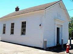
The Center School | |
  | |
| Location | Center St., Prospect, Connecticut |
|---|---|
| Coordinates | 41°30′4″N 72°58′42″W / 41.50111°N 72.97833°WCoordinates: 41°30′4″N 72°58′42″W / 41.50111°N 72.97833°W |
| Area | 13 acres (5.3 ha) |
| Architect | Walters, F.E.; Schoenhardt Architects |
| Architectural style | Greek Revival, Stick/Eastlake, et al. |
| NRHP Reference # | 00000560[1] |
| Added to NRHP | June 16, 2000 |
Prospect Green Historic District is a historic district in the New England town of Prospect, Connecticut. The district is centered on the Prospect Green, the town green.[2] The green is located on the highest settled point in New Haven County. The green is bounded by Route 68 and Center and Church Streets.[3]
The main part of the green is a Civil War Soldiers Monument (1907) situated near the center. Near it is a flag pole and another memorial. At the north end of the green is the town library built in 1903-1904.[3] Several historic buildings surround the green including, the current Congregational Church (built in 1941 and the fourth church on the site), the Grange Hall (1947), the Parsonage (1941), a 19th-century residence once used as a parsonage, and a school house (c. 1865, now used by the local historical society).[2]
The listing includes eight contributing buildings and three noncontributing; one contributing site; two contributing sites and two noncontributing.[2]
See also
| Wikimedia Commons has media related to Prospect Green Historic District. |
References
- ↑ National Park Service (2009-03-13). "National Register Information System". National Register of Historic Places. National Park Service.
- 1 2 3 David F. Ransom (September 1998). "NRHP Inventory-Nomination: Prospect Green Historic District" (PDF). National Park Service. and Accompanying 12 photos, from 1998 (see photo captions pages 13-14 of text document)
- 1 2 Towngreens.com - Prospect Green