Pogoniani
| Pogoniani Πωγωνιανή | |
|---|---|
 Pogoniani | |
|
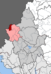
Location within the regional unit  | |
| Coordinates: 40°00′N 20°25′E / 40.000°N 20.417°ECoordinates: 40°00′N 20°25′E / 40.000°N 20.417°E | |
| Country | Greece |
| Administrative region | Epirus |
| Regional unit | Ioannina |
| Municipality | Pogoni |
| • Municipal unit | 56.693 km2 (21.889 sq mi) |
| Population (2011)[1] | |
| • Municipal unit | 567 |
| • Municipal unit density | 10/km2 (26/sq mi) |
| Community[1] | |
| • Population | 425 (2011) |
| • Area (km2) | 18.830 |
| Time zone | EET (UTC+2) |
| • Summer (DST) | EEST (UTC+3) |
| Vehicle registration | ΙΝ |
Pogonianí (Greek: Πωγωνιανή, pronounced [poɣoɲaˈni], before 1928: Βοστίνα - Vostina[2]) is a village and a former community in the Ioannina regional unit, Epirus, Greece. Since the 2011 local government reform it is part of the municipality Pogoni, of which it is a municipal unit.[3] The municipal unit has an area of 56.693 km2, the community 18.830 km2.[4] It is best known in Greece as the birthplace of Karolos Papoulias, President of the Hellenic Republic between 2005 and 2015.
The municipal unit consists of 4 villages: Pogoniani, Dolo, Drymades, Stavroskiadi. During the period prior to the First World War the British member of the International Commission that was responsible of the delineation of the Greek-Albanian border noticed that the villages that were ceded to Albania, which consist of the northern portion of Pogoniani are entirely Greek-speaking.[5]
References
- 1 2 "Απογραφή Πληθυσμού - Κατοικιών 2011. ΜΟΝΙΜΟΣ Πληθυσμός" (in Greek). Hellenic Statistical Authority.
- ↑ Name changes of settlements in Greece
- ↑ Kallikratis law Greece Ministry of Interior (Greek)
- ↑ "Population & housing census 2001 (incl. area and average elevation)" (PDF) (in Greek). National Statistical Service of Greece.
- ↑ British documents on the origins of the war, 1898-1914 ,. H.M.S.O., 1926, p. 184: "Frontier as laid down cut off small northern portion of Pogoniani district which contained Greek villages and was entirely Greek-speaking"