Pilot Mountain State Park
| Pilot Mountain State Park | |
| North Carolina State Park | |
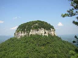
 The distinctive Big Pinnacle of Pilot Mountain | |
| Named for: Pilot Mountain | |
| Country | United States |
|---|---|
| State | North Carolina |
| Counties | Surry, Yadkin |
| Coordinates | 36°20′34.05″N 80°28′57.89″W / 36.3427917°N 80.4827472°WCoordinates: 36°20′34.05″N 80°28′57.89″W / 36.3427917°N 80.4827472°W |
| Highest point | |
| - location | Big Pinnacle |
| - elevation | 2,241 ft (683.1 m) |
| - coordinates | 36°20′24″N 80°28′27″W / 36.34000°N 80.47417°W |
| Lowest point | |
| - location | Yadkin River |
| - elevation | 794 ft (242.0 m) |
| - coordinates | 36°15′22″N 80°30′14″W / 36.25611°N 80.50389°W |
| Area | 3,735 acres (1,511.5 ha) [1] |
| Dedicated | 1968 |
| Management | North Carolina Division of Parks and Recreation |
| IUCN category | III - Natural Monument |
|
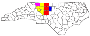
Location of Pilot Mountain State Park in North Carolina | |
| Website: Pilot Mountain State Park | |
Pilot Mountain State Park is a North Carolina state park in Surry and Yadkin Counties, North Carolina in the United States. Located near Pinnacle, North Carolina on highway US 52, it covers 3,735 acres (15.12 km2)[1] and includes the distinctive 2,241 foot (683 m) peak of Pilot Mountain.
History
The Saura, a Native American tribe of the North Carolina Piedmont region, knew the mountain as Jomeokee meaning the Great Guide. It served as a guidepost also for the European settlers of the Carolina who similarly named it Pilot.[2]
The Saura were driven out of the area by the Cherokee. The first European settlers in the area were Moravians, a Christian religious group from Germany that settled in the Thirteen Colonies seeking freedom of religion and to evangelize among the Native Americans. Settlement in the area was slowed until after the American Revolutionary War which relieved tense relations between the Cherokee, the British, and local setters.[2]
After serving as a commercial tourist attraction, Pilot Mountain became a North Carolina state park in 1968. It was established as a state park in order to protect the mountain and surrounding lands from being overdeveloped.[2] The Pilot Mountain Preservation and Park Committee purchased the land from Mrs. J. W. Beasley by raising funds and acquired a grant from the federal government. Additional lands along the Yadkin River were purchased in 1970. Further purchases have brought Pilot Mountain State Park to a total size of 3,703 acres (14.99 km2).[2]
On November 8, 2012 a prescribed burn of 70 acres got out of control leading to a wildfire on the mountain's steep western slope. contained.[3][4]
Recreation
Pilot Mountain State Park is for year-round recreation. Activities at the park include, camping, canoeing, fishing, rock climbing, picnicking, hiking, and environmental education.[5]
The Yadkin River provides opportunities for visitors to the park to fish and canoe. The Yadkin River Canoe Trail is 165 mile (265 km) long and follows the course of the river to its confluence with the Uwharrie River at the Pee Dee River in south central North Carolina. Two miles (3.22 km) of the river pass through Pilot Mountain State Park. The river is broad and shallow at the park with two islands that can be reached by canoe or by wading when the water level is low. All anglers need to have a license from the North Carolina Wildlife Resource Commission. The common game fish are sunfish, catfish and crappie.[5]
A family camping area is on the lower slopes of Pilot Mountain. It has 49 campsites that are open to tents or trailers that are scattered in a forest of hickory and oak trees. Each campsite comes equipped with a charcoal grill, picnic table and tent pad. Modern restroom facilities with hot water and showers are located nearby. A large and rustic youth group camping area is located on the north side of the park's Yadkin River Section. Canoeists are not permitted to camp on the islands of the river. A designated canoe campsite on the bank is available by reservation by contacting the park office.[5]
There are three picnic areas at Pilot Mountain State Park. One picnic area is near the summit parking lot and two are near the Yadkin River. The area has many picnic tables and grills. No drinking water is available in this area. Pit toilets are available.[5]
Rock climbing is permitted in some designated sections of the park. All climbers must register with park staff. Climbing and rappelling are not permitted on the face of Pilot Mountain, Big Pinnacle. A list of rules and regulations can be obtained from the park offices.[5] Many miles of trail at Pilot Mountain State Park are open to hiking and horse back riding. Rules and regulations can be obtained at the park offices.[5]
Ecology
The ecology of Pilot Mountain State Park is similar to the ecology of the Blue Ridge Mountains which are west of Surry County. Big Pinnacle is ringed by Catawba rhododendron which has pink blossoms in the spring, making the mountain appear as if it is wearing a "pink crown".[6] Mountain laurel can be found throughout the park as can wild blueberry, huckleberry and grapes. The forests are mainly chestnut oak, Table Mountain pine and pitch pine trees. Wildlife consists of animals that are typical to an eastern woodland environment including the American toad, Carolina wren, ravens, white-tailed deer and raccoons.[6]
Nearby state parks
The following state parks are within 30 miles (48 km) of Pilot Mountain State Park:
See also
References
- 1 2 "Size of the North Carolina State Parks System" (XLS). North Carolina Division of Parks and Recreation. January 1, 2016. Retrieved February 3, 2015.
- 1 2 3 4 "Pilot Mountain State Park: History". North Carolina Department of Environment and Natural Resources. Retrieved 2007-11-21.
- ↑ Pilot Mountain fire out of control, 100 acres consumed: Wildfire 0 percent contained, began as prescribed burn, WXII-TV, 3:20 PM EST Nov 09, 2012.
- ↑ Watts, Kathy Norcross and Hewlett, Michael. "Wildfire burns on Pilot Mountain", Winston-Salem Journal, November 9, 2012.
- 1 2 3 4 5 6 "Pilot Mountain State Park: Activities". North Carolina Department of Environment and Natural Resources. Retrieved 2007-11-21.
- 1 2 "Pilot Mountain State Park: Ecology". North Carolina Department of Environment and Natural Resources. Retrieved 2007-11-21.
