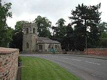
Oxton, Nottinghamshire
Oxton is a village in Nottinghamshire, England, with a 568 residents at the 2011 census.[1]It is located 5 miles west of Southwell, 5 miles north of Lowdham, 10 miles NE of Nottingham and 2 miles NE of Calverton, and lies on the B6386, and is very close to the A6097 trunk road.
Oxton has a church dedicated to St Peter & St Paul;[2] a post office and two pubs. Oxton also has two fords – a small ford within the village itself, and a much larger ford on Beanford Lane – often as deep as 1 ft whilst remaining open to all traffic. It is however closed each March, so that the toads found in the swamp-like area,which the ford crosses, can breed.
Toponomy
Oxton seems to contain the Old English word for an ox, oxa, + tūn (Old English), an enclosure; a farmstead; a village; an estate.., so 'Ox farm or settlement'.[3]
Notable resident
- Robert St Vincent Sherbrooke, awarded the Victoria Cross, was born in Oxton.[4]
Bus services
Nottingham city transport
47
Nottingham – Mapperley – Mapperley Plains – Lambley – Woodborough – Calverton – Oxton – Epperstone – Lowdham
References
- ↑ "Civil Parish population 2011". Neighbourhood Statistics. Office for National Statistics. Retrieved 14 April 2016.
- ↑ N. Pevsner, The Buildings of England: Nottinghamshire (1979), p.286
- ↑ J. Gover, A. Mawer & F. M. Stenton (eds.), Place Names of Nottinghamshire (Cambridge, 1940), p.172; A.D.Mills, Dictionary of English Place-Names (Oxford, 2002), p.265; E .Ekwall, Concise Oxford Dictionary of English Place-names (Oxford, 1960), p.356
- ↑ The London Gazette: (Supplement) no. 35859. pp. 283–284. 8 January 1943. Retrieved 9 July 2015.
External links
![]() Media related to Oxton, Nottinghamshire at Wikimedia Commons
Media related to Oxton, Nottinghamshire at Wikimedia Commons
Coordinates: 53°03′18″N 1°03′43″W / 53.055°N 1.062°W
