Osleston
| Osleston | |
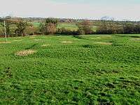
 The remains of the medieval village of Osleton |
|
 Osleston |
|
| Population | 267 (2011) |
|---|---|
| OS grid reference | SK248371 |
| Civil parish | Osleston and Thurvaston |
| District | South Derbyshire |
| Shire county | Derbyshire |
| Region | East Midlands |
| Country | England |
| Sovereign state | United Kingdom |
| Post town | ASHBOURNE |
| Postcode district | DE6 |
| Police | Derbyshire |
| Fire | Derbyshire |
| Ambulance | East Midlands |
| EU Parliament | East Midlands |
|
|
Coordinates: 52°55′52″N 1°37′55″W / 52.931°N 1.632°W
Osleston is a hamlet which together with Thurvaston makes up the parish of Osleston and Thurvaston. The civil parish population at the 2011 Census was 267.[1] It is 7.5 miles (12.1 km) north west of Derby.
In 1848, Osleston, (with Thurvaston), was a place, in the parish of Sutton-on-the-Hill It was recorded as having 1,588 acres (6.43 km2), of which 842 are in Orleston hamlet, and 746 in that of Thurvaston; in each is a small rural village, and the township also includes the scattered village of Cropper, where the Primitive Methodists have a place of worship.[2]
References
- ↑ "Civil Parish population 2011". Neighbourhood Statistics. Office for National Statistics. Retrieved 1 April 2016.
- ↑ 'Osleston - Otley', A Topographical Dictionary of England (1848), pp. 486-491. URL: http://www.british-history.ac.uk/report.aspx?compid=51196. Date accessed: 23 February 2008.
This article is issued from Wikipedia - version of the 4/1/2016. The text is available under the Creative Commons Attribution/Share Alike but additional terms may apply for the media files.