Orthodromic navigation
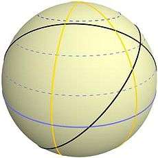
Orthodromic course drawn on the earth globe.
The orthodromic navigation (related to orthodromic course; from the Greek ορtóς, right angle, and δρóμος, path) is a way to navigate following an arc of great circle corresponding to the shortest distance between two points on the globe.[1]
Since the Earth is roughly a sphere, the orthodromic distance of the is often used by mariners to find the distance between two coordinates (knowing its longitude and its latitude) on a map, and the course to be taken to go from one to the other.
Calculation

- is the radius of the earth 6.367.000 meter).
- is the latitud (in radians).
- is the longitude (in radians).
- is the great circle arc, the shortest path between two points on the earth's globe


Comparison Chart

Comparison, of orthodromic course (white) compared with a loxodromic course (red).
See also
- Loxodromic navigation.
- Windrose network.
- Map
- Portolan map
- Marine sandglass
- Compass rose
- Isoazimuthal
References
- ↑ Adam Weintrit; Tomasz Neumann (7 June 2011). Methods and Algorithms in Navigation: Marine Navigation and Safety of Sea Transportation. CRC Press. pp. 139–. ISBN 978-0-415-69114-7.
External links
This article is issued from Wikipedia - version of the 8/26/2016. The text is available under the Creative Commons Attribution/Share Alike but additional terms may apply for the media files.