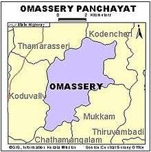
Omassery
| Omassery ഓമശേരി ഓമശേരി | |
|---|---|
| Town | |
|
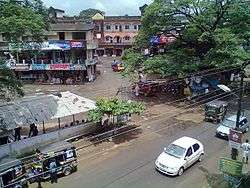
Omassery bus stand | |
| Coordinates: 11°18′0″N 75°58′30″E / 11.30000°N 75.97500°ECoordinates: 11°18′0″N 75°58′30″E / 11.30000°N 75.97500°E | |
| Country |
|
| State | Kerala |
| District | Kozhikode |
| Government | |
| • Body | Omassery |
| • Member of Parliament | MK RAGHAVAN |
| • M.L.A | VM Ummer Master |
| • Panchayath President | KM Komala Valli |
| Area | |
| • Total | 25.46 km2 (9.83 sq mi) |
| Population (2011) | |
| • Total | 25,420 |
| • Density | 998/km2 (2,580/sq mi) |
| Languages | |
| • Official | Malayalam, English |
| Time zone | IST (UTC+5:30) |
| PIN | 673582 |
| Telephone code | 91495228 |
| Vehicle registration | KL-57 |
| Nearest city | Kozhikode |
| Sex ratio | 1000:1032 ♂/♀ |
| Literacy | 88.05%% |
| Lok Sabha constituency | Kozhikode |
| Civic agency | Omassery |
Omassery is a town in Kozhikode district, Kerala, India and it is a junction between Thiruvambady, Thamarassery, Mukkam, Koduvally, Kodencheri and Kattangal. Omassery is located 29 kilometers southeast of Kozhikode in the eastern part of Kerala; better known as Malabar (Northern Kerala). Omassery is a fast developing place and is well connected to the other parts of the state. Besides that, it is known as the gateway to the hill ranges of Western Ghats in Malabar.
Geography
Omassery is located at 11°18′0″N 75°58′30″E. The total area of the Panchayath is 25.46 km².[1]
Demographics
As of 2001 census the total population of the panchayath is 25,420 ,[2] which constitute 12511 Males and 12909 females. The population density is 998 per km² which is more than the state average. The sex ratio is 1000:1032. The people are highly literate. The literacy rate is 88.05 (Male: 93.62 and female 82.76).
Towns and suburbs of Omassery
Koduvally, Kunnamangalam, Thamarassery, Mukkam, Thiruvambady, Kodenchery, NIT (REC)
Koodathai, Venappara, Neeleswaram, Ambalakkandy, Vennakode, Malayamma,Velimanna, Kallurutty, Puthur, Nadammal Poyil & Manipuram
Landmarks
- Pleasant English School
- Vadhi Hudha School
- Alirshad SChool
- Cholakkal Juma Masjidh
- Nadukil Shiva temple
- Puthur Subramanya Temple
- Holy Family Church, Venappara
- Thechyad Juma Masjid
- Velimanna Juma Masjid
- Kulikkapra Mahadeva kshethram,Ambalathingal
Nonprofit Organisations
- CMCO GCC, Cholakkal Mahall Charity Omassery An initiation by 150+ peoples from Omassery Cholakkal Mahall who works in GCC countries
- Sukrutham: A charity initiative by Santi Hospital Omassery for the Kidney patients of the underprivileged sections of the society whose numbers are increasing day by day. Since its inception on May 2008 m ore than 2000 dialysis have been conducted out of which 68% received concession.[3]
- Pain and Palliative Care Clinic: This clinic is guided by the Pain and Palliative Society of Calicut, Government Medical College which has a team of highly qualified and trained doctors accompanied by nurses and volunteers. The clinic was incepted in the year 2003, until now more than 250 patients have been registered in the clinic and among them about 55% were cancer patients.[4]
- Islamic Welfare Trust:Founded in 1979 it is multifaceted charitable organization with the sole objective to uplift the underprivileged sections of the society through education and medical care.
Panchayath Wards and present members
Omassery Panchayath consists of 19 wards. In ward number order, with ward, member name and party indicated:[5]
- Koodathai K.P. KUNHAMMED (INDEPENDENT)
- Kakkadakunnu SHYNI (CPIM)
- Chemmaruthai MANU E J (INC)
- Peruvilly Gracy (INC)
- Korothiri GIRIJA SUMOD KUMAR (CPIM)
- Omassery EAST BIJU AREEKKAL (INDEPENDENT)
- Omassery WEST P.V ABDU RAHIMAN MASTER (IUML)
- Ambalakkandy FATHIMA VADAKKINIKKANDY (IUML)
- Allumthara SUHARABI NECHOOLI (IUML)
- Vennakkode C.K. KHADEEJA MUHAMMED (IUML)
- NadammalPoyil M.C.RAFEENATHULUKHAN(IUML)
- Kaniyarkandam VASANTHA RAJENDRAN (INDEPENDENT)
- Kulathakkara K.T.SAKKEENA TEACHER(IUML)
- Velimanna KUNHIMOIDEEN (IUML)
- Puthur. AJITHAKUMARI(INC)
- Mangad WEST CHANDRAMATHI PUTHANPURAYIL(CPIM)
- Mangad EAST SREEBA AREEKKAL (CPIM)
- Chakkikave T.T.MANOJKUMAR (CPIM)
- Meppally K.K.RADHAKRISHNAN (CPIM)
Transport
- By Air
Calicut International Airport (Karipur), the nearest airport is just 36 kilometres away from this area.
By Train
The nearest Railway station is at Kozhikode.
How to reach by Road
- Thiruvananthapuram - Kochi - Guruvayoor/Thrissur - Pattambi - Perinthalmanna - Manjeri - Areekode - Mukkam - Omassery
- Kozhikode - Kunnamangalam - REC (NIT) / Koduvally - Omassery
- Kannur - Koyilandy - Thamarassery - Omassery
- Wayanad - Adivaram -Thamarassery - Omassery
- Nilambur - Areekode - Mukkam -Omassery
Omassery is on the State Highway (Koyilandy - Edavanna). The location is well connected by roads from various corners and is a main junction for surrounding various panchayaths and villages. Moreover, it gives more geographical importance to this place as this is an important gateway to the hill ranges of western Ghat of Malabar.Thiruvambady, Thamarassery, Koduvally, Mukkam and Kodencheri are near by places of Omassery.
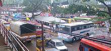
There is one bus stand and bus services available to places such as Kozhikode, Mukkam, Koduvally, Thamarassery, Thiruvambady, Kodenchery, Anakkam Poyil.
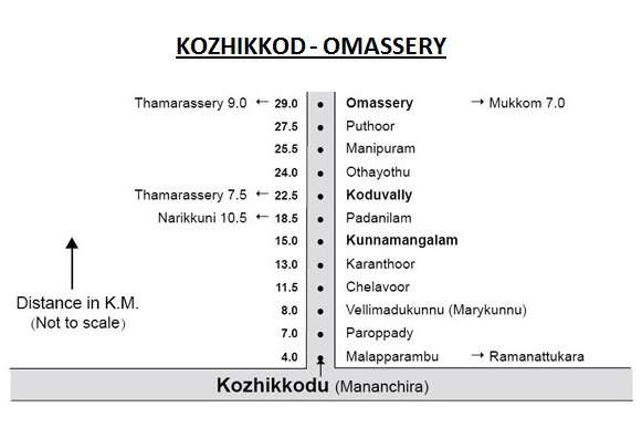
The Kilometer chart from Kozhikode to Omassery is given below.
The Kilometer chart through road from Omassery is given below.
| Kozhikode - 29 km | Thamarassery - 9 km | Manjeri - 36 km |
| Mukkam - 7 km | Malappuram - 48 km | Ernakulam - 202 km |
| Perinthalmanna - 60 km | Areekode - 20 km | Palakkad - 122 km |
| Thiruvambady - 6 km | Thrissur - 133 km | Anakkampoyil - 19 km |
| Koduvally - 6 km | Koyilandy - 37 km | Thiruvananthapuram - 414 km |
| Kodencheri - 10 km | Kalpetta - 58 km | Nilambur - 50 km |
See also
References
External links
| Wikimedia Commons has media related to Omassery. |