Olià
| Olià | |
|---|---|
| Municipality | |
 | |
| Coordinates: 42°21′18″N 1°44′36″E / 42.35500°N 1.74333°ECoordinates: 42°21′18″N 1°44′36″E / 42.35500°N 1.74333°E | |
| Country |
|
| Province | Lleida |
| Comarca | Cerdanya |
| Town | Bellver de Cerdanya |
| Elevation | 1,080 m (3,540 ft) |
| Population (2016) | |
| • Total | 13 |
| Demonym(s) | Olianenc, Olianenca |
| Time zone | CET (UTC+1) |
| • Summer (DST) | CEST (UTC+2) |
| Postal code | 25721 |
| Official language | Catalan |

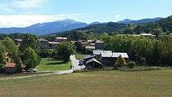
Olià (Catalan: Olià) is located 1080 m above sea level and is a small village belonging to the municipality of Bellver de Cerdanya, Cerdanya (Catalonia) [1]
Demographics
In 2016, the population was 13 people of which six were men and seven women. In the summer, Olià's population increases due to second homes.[2]
| 1970 | 1980 | 1990 | 2000 | 2010 | 2016 |
|---|---|---|---|---|---|
| 19 | 18 | 13 | 6 | 10 | 13 |
Vegetation
Olià is bounded on the north by the Cadí-Moixeró Natural Park, and on the south by the village of Santa Eugènia Nerellà. Olià is surrounded by forests of mainly pine trees. Formerly the villagers were engaged in agriculture and livestock, and mainly lived on the milk production of the cows and also of sheep.
How to get to Olià?

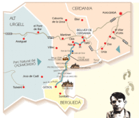
The Route of the Reapers (La Ruta dels Segadors in Catalan)
The Route of the Reapers is a very old way, which runs through the Cadí-Moixeró Natural Park.
This route also includes Olià that comes from Nas town continues to Pi town.
