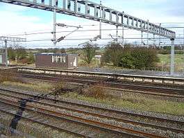
Norton Bridge railway station
| Norton Bridge | |
|---|---|
 | |
| Location | |
| Place | Norton Bridge |
| Local authority | Borough of Stafford |
| Grid reference | SJ872298 |
| Operations | |
| Station code | NTB |
| Managed by | London Midland |
| Number of platforms | 2 |
| DfT category | F2 |
|
Live arrivals/departures, station information and onward connections from National Rail Enquiries | |
| Annual rail passenger usage* | |
| 2002/03 |
|
| 2004/05 |
|
| 2005/06 |
|
| 2006/07 |
|
| History | |
| 1837 | opened |
| 2004 | Service suspended |
| National Rail – UK railway stations | |
| * Annual estimated passenger usage based on sales of tickets in stated financial year(s) which end or originate at Norton Bridge from Office of Rail and Road statistics. Methodology may vary year on year. | |
|
| |
Norton Bridge railway station is four miles north-west of Stafford on the West Coast Main Line near the village of Norton Bridge in Staffordshire, England.
The station was opened by the Grand Junction Railway in 1837.[1]:37
The main line platforms were removed before electrification in the 1960s. The island platform serving the Manchester via Stoke-on-Trent branch of the WCML has been out of use since 2004 when the footbridge was removed in order to improve freight clearances.[2] The passenger train service was replaced by a bus service.[2]
From 2007, the Office of Rail Regulation no longer counted usage figures.[3]
The nearby junction between the Crewe and Stoke routes is an important one on the West Coast Main Line, as such during the 1960s modernisation of the line, the junction and some of the surrounding main lines were placed under the control of a new power signal box built to a similar design to that still standing at Wolverhampton. The Norton Bridge signal box was notable for its use of an experimental Westinghouse solid-state interlocking system for some years,[4] later being converted to a conventional relay-based interlocking; this signal box features briefly in the British Transport Films production "Thirty Million Letters". It closed altogether in 2004,[5] control passing instead to the signal control centre at Stoke, although the lower storey still remains in situ as a relay room.
In March 2016, a new £250 million flyover was opened just to the north of here to allow the Stoke branch to be fully grade-separated from the main line to Crewe. Services to/from Manchester now use the slow lines from Stafford, a new junction near Little Bridgeford and the new flyover instead of having to make potentially conflicting moves across the flat junction as before.[6]
On 19 October 2016 the Department of Transport begun a consultation process proposing to officially close the station from 15 October 2017 and withdraw subsidy of the replacement bus service.[7][2]
References
- ↑ Drake, James (1838). Drake’s Road Book of the Grand Junction Railway (1838). Moorland Reprints. ISBN 0903485257.
- 1 2 3 Milner, Chris, ed. (November 2016). "Norton Bridge 2017 closure plan moves step nearer". The Railway Magazine. 162 (1388): 9.
- ↑ Cheesewright, Phil (2009-04-20). "Station usage 2007/2008" (PDF). Delta Rail. p. Page 8. Retrieved 2009-07-28.
- ↑ http://www.irse.org/knowledge/publicirsenews/IRSENews161Nov10_web.pdf
- ↑ http://www.signalbox.org/sectionc.php?year=2004
- ↑ "£250m upgrade improves railway near Stafford as new Norton Bridge flyover opens"Network Rail Media Centre press release 30 March 2016; Retrieved 23 September 2016
- ↑ "Norton Bridge Station Closure - Open Consulation"Department for Transport consultation notice 19 October 2016
External links
| Wikimedia Commons has media related to Norton Bridge railway station. |
- Train times and station information for Norton Bridge railway station from National Rail
| Preceding station | |
Following station | ||
|---|---|---|---|---|
| Stafford Line and station open |
London Midland Stafford to Manchester Line |
Stone Line and station open | ||
| Historical railways | ||||
| Bridgeford Line and station open |
London and North Western Railway Grand Junction Railway |
Standon Bridge Line open, station closed | ||
Coordinates: 52°51′57″N 2°11′25″W / 52.86583°N 2.19028°W