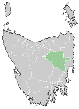
Northern Midlands Council
| Northern Midlands Council Tasmania | |||||||||||||
|---|---|---|---|---|---|---|---|---|---|---|---|---|---|
 Northern Midlands Council | |||||||||||||
| Coordinates | 41°45′56″S 147°23′11″E / 41.76556°S 147.38639°ECoordinates: 41°45′56″S 147°23′11″E / 41.76556°S 147.38639°E | ||||||||||||
| Population | 12,749 (2015 est.)[1] | ||||||||||||
| • Density | 2.4852/km2 (6.437/sq mi) | ||||||||||||
| Established | 1993 | ||||||||||||
| Area | 5,130 km2 (1,980.7 sq mi) | ||||||||||||
| Mayor | David Downie | ||||||||||||
| Council seat | Longford | ||||||||||||
| Region | Northern midlands | ||||||||||||
| State electorate(s) | Lyons | ||||||||||||
| Federal Division(s) | Lyons | ||||||||||||
 | |||||||||||||
| Website | Northern Midlands Council | ||||||||||||
| |||||||||||||
The Northern Midlands Council or Municipality of Northern Midlands is a local government area of Tasmania. It covers the northern part of the central midlands agricultural area, around the Midland Highway.
Major population centres include the towns of Avoca, Campbell Town, Cressy, Evandale, Longford, and Perth. At the 2014 elections former Deputy Mayor, David Downie, was elected mayor after the retirement of long serving Mayor Kim Polley.
Suburbs[2]
| Suburb | Census Population 2011 | Reason |
|---|---|---|
| Evandale | 1402 | |
| Longford | 3756 | Includes Bishopsbourne, Toiberry, Wilmores Lane, Pateena, Illawarra |
| Campbell Town | 994 | |
| Perth | 2635 * | * Missing from ABS |
| Bishopsbourne | Incl. in Longford | |
| Toiberry | Incl. in Longford | |
| Wilmores Lane | Incl. in Longford | |
| Pateena | Incl. in Longford | |
| Breadalbane | Incl. in Western Junction | |
| Devon Hills | 476 | |
| Western Junction | 298 | Includes Breadalbane |
| Clarendon | Incl. in Conara | |
| Deddington | 77 | Includes Blessington,English Town |
| Nile | Incl. in Conara | |
| Blessington | Incl. in Deddington | |
| English Town | Incl. in Deddington | |
| Storys Creek | Incl. in Avoca | |
| Rossarden | Incl. in Avoca | |
| Avoca | 300 | Includes Storys Creek, Rossarden, Royal George, LLewellyn, Frodberry (Break O'Day Council) |
| Royal George | Incl. in Avoca | |
| Lake Leake | ||
| Tooms Lake | Incl. in Ross | |
| Ross | 423 | Includes Tooms Lake, Auburn |
| Auburn | Incl. in Ross | |
| Delmont | Incl. in Cressy | |
| Poatina | Incl. in Cressy | |
| Blackwwod Creek | Incl. in Cressy | |
| Cressy | 1403 | Includes Delmont, Poatina, Blackwood Creek, Millers Bluff |
| Epping Forest | Incl. in Conara | |
| Conara | 484 | Includes Epping Forest, Cleveland, Clarendon, Nile, Powrana, Barton |
| Cleveland | Incl. in Conara | |
| LLewellyn | Incl. in Avoca | |
| Tunbridge | Incl. in Ross | |
| Powrana | Incl. in Conara | |
| Barton | Incl. in Conara | |
| Millers Bluff | Incl. in Cressy | |
| Illawarra | Incl. in Longford | |
| Total | 12,228 | |
| () | Variance | |
| Local Government Total | 12,228 | Gazetted Central Coast Local Government Area |
References
- ↑ "3218.0 – Regional Population Growth, Australia, 2014–15". Australian Bureau of Statistics. Retrieved 29 September 2016.
- ↑ Australian Bureau of Statistics. "2011 Census QuickStats". Retrieved 28 May 2016.
External links
This article is issued from Wikipedia - version of the 11/29/2016. The text is available under the Creative Commons Attribution/Share Alike but additional terms may apply for the media files.