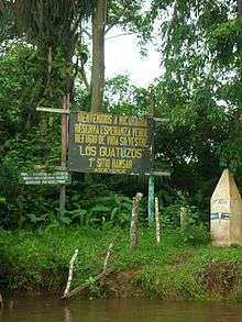
Costa Rica–Nicaragua border

The Costa Rica–Nicaragua border is the line of 309 km long, east-west direction, separating the north of Costa Rica's territory of Nicaragua, extending between the Caribbean Sea (E) and the Pacific Ocean (W) coasts. It passes almost directly on Lake Nicaragua and the River San Juan.
The border separates, from east to west:
- Departments of Nicaragua: Río San Juan Department and Rivas.
- Provinces of Costa Rica: Limón, Heredia, Alajuela and Guanacaste.
These two nations have integrated the United Provinces of Central America from 1826 until 1838, when this Federation was broken. From there, the two nations gained independence, coming into existence this border.
In 2010 the Costa Rican Deputy Foreign Minister Carlos Roverssi, complained that the map published by Google Maps the border between the two states had errors that allowed Nicaraguan military personnel entry into Costa Rica. The map of the Nicaraguan Institute of Territorial Studies (INETER) coincides with the National Geographic Institute of Costa Rica, both based in neighboring Cañas-Jerez Treaty of 1858 and the Cleveland Award, 1888.[1]
See also
References
(in Spanish)