Newton, South Lanarkshire
| Newton, South Lanarkshire | |
| Scottish Gaelic: Am Baile Ùr | |
 Newton, South Lanarkshire |
|
| Council area | South Lanarkshire |
|---|---|
| Country | Scotland |
| Sovereign state | United Kingdom |
| Dialling code | 0141 |
| Police | Scottish |
| Fire | Scottish |
| Ambulance | Scottish |
| EU Parliament | Scotland |
| UK Parliament | Rutherglen and Hamilton West |
| Scottish Parliament | Rutherglen |
Coordinates: 55°49′N 4°07′W / 55.82°N 4.12°W
Newton is a mainly residential district in the Scottish town of Cambuslang in South Lanarkshire Council area (part of the Cambuslang East ward). It is situated south of the River Clyde - the river borders the district to the north.
The name is familiar to many in the Greater Glasgow area as a terminus on the suburban railway system (Newton Station). The railway line marks the southern boundary of the area, while to the west Newton is separated from the neighbouring village of Westburn by the small Newton Burn, and to the east it is separated from farmland belonging to the town of Blantyre by the Rotten Calder river which flows into the Clyde.
History
Mining Village
Originally lands owned by the Clan Hamilton, Newton grew as a mining village in the late 19th Century. Rows of miners’ cottages were built along with local schools, churches and shops. There were several collieries in the vicinity and large bings appeared on the landscape. The settlement reached its greatest extent around 1910.[1][2] The parish town of Cambuslang also became heavily industrialised and grew substantially in population.[3][4][5][6]
Since 1849 the area had been served by a train station, and when this was replaced in 1873 it coincided with the opening of the large Hallside steelworks.[7] However, unlike nearby districts also served by stations on the same lines such as Uddingston, Kirkhill and Burnside, Newton did not become a railway commuter suburb for Glasgow at that time.
The village and mines only occupied a small part of the district. The majority of land was occupied by the fields of Newton Farm bounded by the River Clyde to the north, as well as a small country estate centred around Newton House (this was approached by a bridge across Newton Burn and a tree-lined driveway, with the original mansion dating from the 1600s and the last version built in 1825 [8][9]) and a smaller farm called Ridleywood/Redlawood.
-
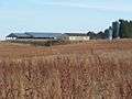
buildings of Newton Farm, now demolished, as viewed from the Clyde Walkway, 2005
-
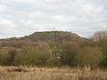
view north from near Newton Station; this scene has changed considerably, the land in the foreground is now housing and the bing has been levelled and is now an informal grass area, 2006
-
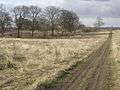
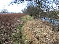
informal path in fields at Newton looking north; trees on left were part of gardens at Newton House, 2006
-
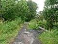
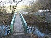
path from Westburn over Newton Burn; this once led to Newton House, bridge now features metal safety fences and some of the trees have been felled, 2009
Post-War Decline
In common with much of post-industrial Scotland, in the years after World War II the landscape of Newton changed considerably.
The mining industry declined and the pits closed, with the industrial areas becoming overgrown, and the miners’ cottages were demolished. The Hallside Steelworks also closed down during the 1970s. Most of the civic amenities and shops closed their doors and the premises were knocked down, leaving derelict ‘gap sites’ which are still present today. However St. Charles Primary School remained in operation.
Newton House was eventually abandoned and demolished around 1950, and Newton Farm ceased operations in the early 2000s, leaving its fields and buildings neglected. A small isolated group of modern houses were added in the mid 1980s with the streets named Redlawood after the neighbouring farm, which had also been bulldozed.
The presence of an electricity generating station nearby resulted in the area being criss-crossed with large electricity pylons and wires, but other than that the land had almost reverted to its original unoccupied rural state after such changes during the previous decades.
Modern Suburb, Phase 1
In the early part of the 21st Century plans were made to transform Newton into a ‘Community Growth Area’ with 2100 new houses to be constructed over the following 20 years as well as a local retail centre and new education and community resources.[10]
The first phase of development began in 2006 near to the train station with housing (by Bellway and Taylor Wimpey). A replacement campus was built for St Charles Primary School [11] and later, further housing areas (by Taylor Wimpey, Persimmon and Miller Homes) concluded ‘Phase 1’ of the development in 2015 with about 600 homes constructed. The street names were themed on aspects of farming and rural life.
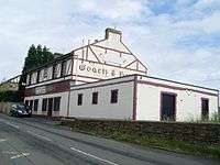
Around the same time the Newton Arms public house (originally dating from 1895) re-opened following a programme of refurbishment, providing a gathering point for the growing population which was otherwise lacking in the development.
Civic improvements were also made in ‘Newton Village’ - the small group of houses at Redlawood Road – including upgraded gym equipment at the local playpark and a small memorial garden reflecting the mining history of the area.
-
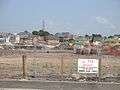
View eastwards over new housing; this is the Bale Avenue/Bale Court area under construction, 2008
-
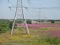
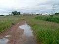
Looking east over the lands of Newton Farm; River Clyde is behind bushes on left, much of land to right of pylons will be converted to housing, 2008
-
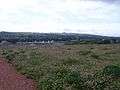
View south from flattened bing; the house building work in the distance is now complete, 2009
-
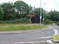
Railway bridge and entrance to station at southern edge of Newton, 2009
-
Looking east towards new housing; the land in this scene (other than the wooded areas) has since been built on or will be in the near future, 2009
Modern Suburb, Phase 2
‘Newton Farm Phase 2’,[12] commenced in 2015. The zone for the first stage of construction, including 600 houses and a new incarnation of Newton primary school (with a 3G football pitch and nursery class, scheduled to open in 2017) [13] is on the land where the buildings of Newton Farm itself previously stood. Barratt Developments,[14] Miller Homes [15] and Taylor Wimpey [16] are the house builders involved - the latter firm is also in overall control of the whole project.
Future development over the next 10 years, which will involve another 900 houses and two local parks, includes the land near to the site of Newton House. The main road will complete a ‘loop’ back to the railway station. That will also be the location of the local retail zone for the district; however as of early 2016 there is no confirmation as to when this commercial area will be built, what exact design it will have, or what businesses will be present.
Amenities
Education
Until the future Newton Primary School is operational, parents in Newton who do not wish their children to receive a Catholic education at local St Charles Primary have to utilise Cairns Primary in the Halfway district of Cambuslang, as the closer schools in the Drumsagard district (Hallside and Park View) are already at capacity due to the considerable amount of new housing in that area in recent years.
There are no secondary schools in Newton. Pupils who live in the area and attend St Charles Primary will transfer to Trinity High School while pupils who attend Cairns/Newton Primary Schools (see above) will transfer to Uddingston Grammar School. The situation has proven controversial, due to pupils from schools in Drumsagard being allocated to both Cathkin High School (nominally in Cambuslang but a considerable distance from both Drumsagard and Newton) and to Stonelaw High School in Rutherglen due to capacity issues - some parents felt this would cause splits in the community of Cambuslang.[17][18][19]
Commerce
Currently there are no shops in Newton itself (although small businesses are based near to the public house: a taxi company, hairdresser and MOT garage). There is a small licensed grocer in Westburn and a neighbourhood retail zone at the south of Drumsagard, albeit these are both a considerable walking distance for many residents of Newton Farm (e.g Westburn store is 1.2 km / 0.8 mile from St Charles school, and Drumsagard shops 2.3 km / 1.5 miles from the same location). Halfway and Cambuslang Main Street have typical general shopping facilities, as well as the closest places of worship for various denominations. There is a modern industrial estate near Westburn.
Transport
Newton railway station is a busy stop for local services linking Glasgow and Lanarkshire on two different lines (Cathcart Circle Lines and Argyle Line). Additionally, high-speed trains on the West Coast Main Line pass Newton on separate lines which are also used by the suburban Shotts Line, meaning several trains of various types can be seen and heard each hour throughout the day.
The nearest connecting stations to Newton are Rutherglen and Cambuslang to the west and Blantyre to the east on the Argyle line, and Kirkhill on the westbound Cathcart Circle line (Newton is the east terminus for this line). Other nearby stations on different lines are Carmyle which has a common link at Rutherglen, and Uddingston which has a common link at Cambuslang.
Bus services are fairly limited at present. First Glasgow 7A service (to/from Summerston via Rutherglen and Glasgow City Centre) starts and ends at Newton, as does the 364 (to/from Parkhead), but these are infrequent services. The major First route to Lanarkshire, the 267 service, travels through Cambuslang and Halfway but is a considerable walking distance from Newton at its closest point (e.g. 1.8 km / 1.1 mile from St Charles Primary School to Halfway Park bus stops).
The opening of the M74 Motorway extension between Cambuslang and Tradeston in Glasgow in 2011 introduced a quick route to and from the Newton area. Motorway connections heading south towards Hamilton and England, or towards northern (M73/M80) or eastern Scotland (M8) have been in place for some years. For visitors unfamiliar with the local road network, Junction 2A (Cambuslang/Tollcross) is the most suitable exit as it serves both north and southbound lanes. On suburban roads, generally drivers should follow signs for Cambuslang and then Halfway or Westburn – Newton itself is poorly signposted due to its small population until recently.
Recreation
As of 2016 there is little in the way of organised sport in Newton, although this situation may change when the primary school with its community facilities is finished. Fitness classes are held at St. Charles school on evenings and weekends. There are numerous participation and spectator sports organisations based in Cambuslang and the closest community facility is Westburn Hall.[20]
The main recreational features of note in the area are:
• National Cycle Route 75 (Glasgow-Edinburgh) which runs through Westburn as a standalone tarmac cycle path, then switches onto the main roads and runs parallel with the railway line past Newton and towards Uddingston.[21]
• The Clyde Walkway (Glasgow-Lanark) runs alongside the River Clyde to the north of Newton and passes houses under construction and woodland before joining the footpath down to the Rotten Calder and across a footbridge leading on to Uddingston.[22]
• A basic grass football field and goals in Newton Village, with an ‘outdoor gym’ and enclosed play area for young children.
• Further play areas at Shepherds Way and Fallow Grove.
The areas of grassland and woods around Newton are home to various bird and animal species, including a herd of roe deer which are sighted on a regular basis in various locations by residents.
People From Newton
• Hugh McIver (soldier killed in World War I, recipient of Victoria Cross medal)
• Sheldon B. Govier (footballer, USA National Soccer Hall of Fame member)
• Willie McAulay (footballer, Aberdeen)[23]
• Davie Wilson (footballer, Rangers and Scotland[24]
Notes and references
- ↑ "Cambuslang – Scottish Mining Website".
- ↑ "Vision Of Britain – Newton Lanarkshire".
- ↑ "Scotland's Places - Map of Cambuslang in 1859".
- ↑ "Scotland's Places - Map of Cambuslang in 1896".
- ↑ "Scotland's Places - Map of Cambuslang in 1910".
- ↑ "Scotland's Places - Map of Cambuslang in 1934".
- ↑ "Hallside Steelworks – Colin Findlay".
- ↑ "Old Houses Of Glasgow – Newton".
- ↑ "The Glasgow Story - Newton House".
- ↑ "Ashfield Land – Newton Farm".
- ↑ "St Charles Primary School Newton".
- ↑ "Newton Farm Documents on South Lanarkshire Council Planning Web Resource".
- ↑ "Newton Primary School Construction Project".
- ↑ "Barratt at Newton Farm".
- ↑ "Miller at Newton Park".
- ↑ "Taylor Wimpey at Newton Farm".
- ↑ "STV News: Parents React Angrily To New School Plans (2011)".
- ↑ "Two new primary schools to be built in Halfway and Newton (2012)".
- ↑ "Daily Record: Newton primary to open a year later due to legal hold up (2015)".
- ↑ "SLC – Westburn Community Hall".
- ↑ "Sustrans – National Cycle Route 75".
- ↑ "Walk Highlands - Clyde Walkway (Newton is described in Section 2)".
- ↑ "AFC Heritage profile of Willie McAulay".
- ↑ "Daily Record - Tribute to one Of Newton's favourite sons Davy Wilson (2015)".