| [3] |
Name on the Register[4] |
Image |
Date listed[5] |
Location |
City or town |
Description |
|---|
| 1 |
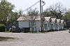
3 V Tourist Court |
|
000000001993-01-21-0000January 21, 1993
(#92001832) |
111 E. Commerce St.
30°46′44″N 91°22′32″W / 30.778889°N 91.375556°W / 30.778889; -91.375556 (3 V Tourist Court) |
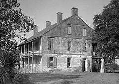
St. Francisville |
|
| 2 |
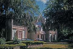
Afton Villa Gardens |
|
000000001983-02-24-0000February 24, 1983
(#83000554) |
North of St. Francisville on U.S. Route 61
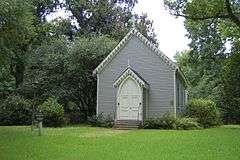
30°51′06″N 91°23′17″W / 30.851667°N 91.388056°W / 30.851667; -91.388056 (Afton Villa Gardens) |
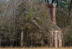
St. Francisville |
|
| 3 |
Bloodhound Site |
Upload image |
000000001983-05-02-0000May 2, 1983
(#83000555) |
Address Restricted
|
Angola |
An archaeological site once occupied by the Tunica tribe.
|
| 4 |
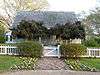
Butler-Greenwood Plantation |
Upload image |
000000001979-04-17-0000April 17, 1979
(#79001103) |
North of St. Francisville on U.S. Route 61
30°49′11″N 91°23′23″W / 30.819722°N 91.389722°W / 30.819722; -91.389722 (Butler-Greenwood Plantation) |
St. Francisville |
|
| 5 |
Catalpa |
Upload image |
000000001984-07-12-0000July 12, 1984
(#84001367) |
U.S. Route 61
30°51′04″N 91°22′33″W / 30.851111°N 91.375833°W / 30.851111; -91.375833 (Catalpa) |
St. Francisville |
|
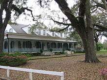
| 6 |
Cottage Plantation |
Upload image |
000000001975-03-17-0000March 17, 1975
(#75000857) |
6 miles north of St. Francisville on U.S. Route 61
30°51′11″N 91°21′37″W / 30.853056°N 91.360278°W / 30.853056; -91.360278 (Cottage Plantation) |
St. Francisville |
|
| 7 |
John S. Dawson High School |
Upload image |
000000002015-06-15-0000June 15, 2015
(#15000348) |
7565 Tunica Trace
30°50′36″N 91°24′06″W / 30.8432°N 91.4018°W / 30.8432; -91.4018 (John S. Dawson High School) |
St. Francisville vicinity |
|
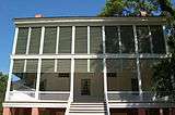
| 8 |
Grace Episcopal Church |
|
000000001979-03-28-0000March 28, 1979
(#79001102) |
510 Ferdinand St.
30°46′33″N 91°23′14″W / 30.775833°N 91.387222°W / 30.775833; -91.387222 (Grace Episcopal Church) |
St. Francisville |
|
| 9 |
Hazelwood Plantation |
|
000000001978-07-31-0000July 31, 1978
(#78001438) |
Southeast of Laurel Hill on Hazelwood Rd.
30°56′56″N 91°19′56″W / 30.948889°N 91.332222°W / 30.948889; -91.332222 (Hazelwood Plantation) |
Laurel Hill |
|
| 10 |
Highland |
Upload image |
000000001983-08-23-0000August 23, 1983
(#83000556) |
Northwest of St. Francisville, off Highland Rd.
30°53′08″N 91°25′49″W / 30.885556°N 91.430278°W / 30.885556; -91.430278 (Highland) |
St. Francisville |
|
| 11 |
Laurel Hill |
Upload image |
000000001980-06-06-0000June 6, 1980
(#80001770) |
Northeast of St. Francisville
30°57′41″N 91°19′33″W / 30.961389°N 91.325833°W / 30.961389; -91.325833 (Laurel Hill) |
St. Francisville |
|
| 12 |
Live Oak |
|
000000001977-03-11-0000March 11, 1977
(#77000680) |
1.3 miles south of Weyanoke
30°56′00″N 91°27′17″W / 30.933333°N 91.454722°W / 30.933333; -91.454722 (Live Oak) |
Weyanoke |
|
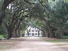
| 13 |
Myrtles Plantation |
|
000000001978-09-06-0000September 6, 1978
(#78001439) |
U.S. Route 61
30°48′11″N 91°23′15″W / 30.803056°N 91.3875°W / 30.803056; -91.3875 (Myrtles Plantation) |
St. Francisville |
|
| 14 |
Oak Grove Plantation Dependencies |
Upload image |
000000001992-02-13-0000February 13, 1992
(#92000036) |
U.S. Route 61, south of its junction with Louisiana Highway 421
30°52′34″N 91°21′58″W / 30.876111°N 91.366111°W / 30.876111; -91.366111 (Oak Grove Plantation Dependencies) |
St. Francisville |
|
| 15 |
Oakley Plantation House |
|
000000001973-01-25-0000January 25, 1973
(#73000878) |
4.5 miles east of St. Francisville at Audubon State Historic Site
30°47′48″N 91°18′26″W / 30.796667°N 91.307222°W / 30.796667; -91.307222 (Oakley Plantation House) |
St. Francisville |
John James Audubon worked here as Eliza Pirrie's art tutor, for four months in 1821. He painted 32 of his famous Birds of America during that time. Audubon's wife Lucy also taught at Oakley.
|
| 16 |
The Oaks |
Upload image |
000000001979-08-20-0000August 20, 1979
(#79001101) |
U.S. Route 61
30°48′34″N 91°23′12″W / 30.809444°N 91.386667°W / 30.809444; -91.386667 (The Oaks) |
Hardwood |
|
| 17 |
Propinquity |
Upload image |
000000001973-03-26-0000March 26, 1973
(#73000879) |
Royal and Johnson Sts.
30°46′27″N 91°23′11″W / 30.774167°N 91.386389°W / 30.774167; -91.386389 (Propinquity) |
St. Francisville |
|
| 18 |
Red Hat Cell Block, Louisiana State Penitentiary |
|
000000002003-02-20-0000February 20, 2003
(#03000041) |
Louisiana State Penitentiary
30°57′56″N 91°36′49″W / 30.965556°N 91.613611°W / 30.965556; -91.613611 (Red Hat Cell Block, Louisiana State Penitentiary) |
Angola |
|
| 19 |
Rosale Plantation |
Upload image |
000000001980-12-08-0000December 8, 1980
(#80001771) |
North of St. Francisville off U.S. Route 61
30°51′52″N 91°21′36″W / 30.864444°N 91.36°W / 30.864444; -91.36 (Rosale Plantation) |
St. Francisville |
|
| 20 |
Rosebank Plantation House |
Upload image |
000000001973-04-13-0000April 13, 1973
(#73000880) |
Southeast of Weyanoke off Louisiana Highway 66
30°55′27″N 91°26′33″W / 30.924167°N 91.4425°W / 30.924167; -91.4425 (Rosebank Plantation House) |
Weyanoke |
|
| 21 |
Rosedown Plantation |
|
000000002001-08-07-0000August 7, 2001
(#01000765) |
U.S. Route 61 and Louisiana Highway 10
30°47′58″N 91°22′23″W / 30.799444°N 91.373056°W / 30.799444; -91.373056 (Rosedown Plantation) |
St. Francisville |
|
| 22 |
St. Francisville Historic District |
Upload image |
000000001980-04-02-0000April 2, 1980
(#80001772) |
Royal and Prosperity Sts.; also Ferdinand and Sewell Sts.
30°46′28″N 91°23′09″W / 30.774444°N 91.385833°W / 30.774444; -91.385833 (St. Francisville Historic District) |
St. Francisville |
Second set of addresses represents a boundary increase of 000000001982-10-01-0000October 1, 1982
|
| 23 |
St. John's Episcopal Church |
|
000000001984-10-04-0000October 4, 1984
(#84000016) |
Old Laurel Hill Rd.
30°57′24″N 91°20′29″W / 30.956667°N 91.341389°W / 30.956667; -91.341389 (St. John's Episcopal Church) |
Laurel Hill |
|
| 24 |
St. Mary's Episcopal Church |
|
000000001980-09-29-0000September 29, 1980
(#80001774) |
Northwest of Weyanoke on Louisiana Highway 66
30°57′56″N 91°28′11″W / 30.965556°N 91.469722°W / 30.965556; -91.469722 (St. Mary's Episcopal Church) |
Weyanoke |
|
| 25 |
Solitude Plantation House |
Upload image |
000000001983-01-27-0000January 27, 1983
(#83000558) |
Northwest of St. Francisville on Tunica Rd.
30°49′17″N 91°25′26″W / 30.821389°N 91.423889°W / 30.821389; -91.423889 (Solitude Plantation House) |
St. Francisville |
|
| 26 |
Star Hill Plantation Dependency |
Upload image |
000000002003-07-24-0000July 24, 2003
(#03000680) |
5018 U.S. Route 61
30°45′56″N 91°19′00″W / 30.765556°N 91.316667°W / 30.765556; -91.316667 (Star Hill Plantation Dependency) |
Star Hill |
|
| 27 |
Star Hill Post Office and Store |
Upload image |
000000002000-02-04-0000February 4, 2000
(#00000038) |
4630 U.S. Route 61
30°45′43″N 91°18′24″W / 30.761944°N 91.306667°W / 30.761944; -91.306667 (Star Hill Post Office and Store) |
St. Francisville |
|
| 28 |
Trudeau House |
Upload image |
000000001995-07-28-0000July 28, 1995
(#95000919) |
Junction of Louisiana Highway 66 and Old Tunica Rd.
30°56′06″N 91°32′15″W / 30.935°N 91.5375°W / 30.935; -91.5375 (Trudeau House) |
Tunica |
|
| 29 |
Trudeau Landing |
Upload image |
000000001977-06-17-0000June 17, 1977
(#77000679) |
Address Restricted
|
Tunica |
An archaeological site once occupied by the Tunica tribe.
|
| 30 |
Wakefield |
Upload image |
000000001980-06-06-0000June 6, 1980
(#80001773) |
U.S. Route 61
30°53′18″N 91°21′14″W / 30.888333°N 91.353889°W / 30.888333; -91.353889 (Wakefield) |
Wakefield |
|
| 31 |
Weyanoke |
Upload image |
000000001990-11-15-0000November 15, 1990
(#90001750) |
Sligo Rd., 5 miles north of its junction with Louisiana Highway 66
30°56′14″N 91°25′03″W / 30.937222°N 91.4175°W / 30.937222; -91.4175 (Weyanoke) |
Weyanoke |
|