National Register of Historic Places listings in Asotin County, Washington
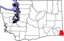
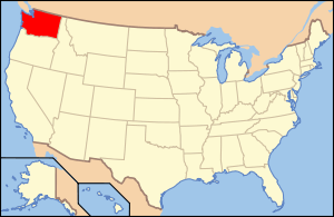
Location of Asotin County in Washington
This list presents the full set of buildings, structures, objects, sites, or districts designated on the National Register of Historic Places in Asotin County, Washington, and offers brief descriptive information about each of them. The National Register recognizes places of national, state, or local historic significance across the United States.[1] Out of over 90,000 National Register sites nationwide,[2] Washington is home to approximately 1,500,[3] and 9 of those are found in Asotin County.
- This National Park Service list is complete through NPS recent listings posted December 2, 2016.[4]
Current listings
| [5] | Name on the Register | Image | Date listed[6] | Location | City or town | Description |
|---|---|---|---|---|---|---|
| 1 | Clarkston Public Library | 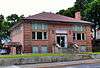 |
(#82004193) |
6th and Chestnut Sts. 46°24′38″N 117°02′43″W / 46.410667°N 117.045246°W |
Clarkston | Carnegie Libraries of Washington TR |
| 2 | Cloverland Garage | 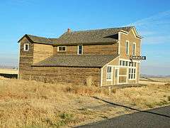 |
(#86000895) |
CR 01050 46°15′08″N 117°15′00″W / 46.252222°N 117.25°W |
Cloverland | |
| 3 | Full Gospel Church | 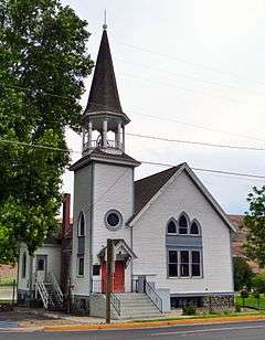 |
(#72001266) |
1st and Monroe Sts. 46°20′28″N 117°03′05″W / 46.341078°N 117.051352°W |
Asotin | |
| 4 | Grande Ronde River Bridge | 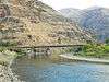 |
(#95000262) |
WA 129 over the Grande Ronde R. 46°02′30″N 117°15′04″W / 46.041667°N 117.251111°W |
Asotin | Bridges of Washington State MPS |
| 5 | Indian Timothy Memorial Bridge | 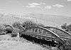 |
(#82004194) |
Spans Alpowa Creek 46°24′43″N 117°12′46″W / 46.411944°N 117.212778°W |
Pomeroy | Historic Bridges and Tunnels in Washington TR |
| 6 | Nez Perce Snake River Archeological District | Upload image | (#78001086) |
Includes the confluence of Redbird Creek and the Snake River[7] 46°14′04″N 116°57′20″W / 46.234444°N 116.955556°W |
Asotin | |
| 7 | Snake River Archeological District | Upload image | (#76001868) |
Address Restricted |
Asotin | |
| 8 | U.S. Post Office – Clarkston Main | 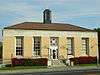 |
(#91000642) |
949 6th St. 46°24′40″N 117°02′39″W / 46.411111°N 117.044167°W |
Clarkston | |
| 9 | C. C. Van Arsdol House |  |
(#75001839) |
15th and Chestnut Sts. 46°24′38″N 117°04′07″W / 46.410438°N 117.068618°W |
Clarkston |
See also
- National Register of Historic Places listings in Washington state
- Listings in neighboring counties: Garfield, Nez Perce, Wallowa, Whitman
- Historic preservation
- History of Washington (state)
- Index of Washington-related articles
References
- ↑ Andrus, Patrick W.; Shrimpton, Rebecca H.; et al. (2002), How to Apply the National Register Criteria for Evaluation, National Register Bulletin (15), National Park Service, U.S. Department of the Interior, retrieved June 20, 2014.
- ↑ National Park Service, National Register of Historic Places Program: Research, retrieved January 28, 2015.
- ↑ Department of Archaeology and Historic Preservation, Washington Information System for Architectural and Archaeological Records Data (WISAARD), retrieved February 14, 2015.
- ↑ "National Register of Historic Places: Weekly List Actions". National Park Service, United States Department of the Interior. Retrieved on December 2, 2016.
- ↑ Numbers represent an ordering by significant words. Various colorings, defined here, differentiate National Historic Landmarks and historic districts from other NRHP buildings, structures, sites or objects.
- ↑ The eight-digit number below each date is the number assigned to each location in the National Register Information System database, which can be viewed by clicking the number.
- ↑ Rice, David G. National Register of Historic Places Inventory-Nomination Form: Nez Perce Snake River Archaeological District. National Park Service, 1977-04-04, 15-16.
External links
- Washington Department of Archaeology and Historic Preservation, Historic Register program
- National Park Service, National Register of Historic Places site
 Media related to National Register of Historic Places in Asotin County, Washington at Wikimedia Commons

| Topics | |
|---|---|
| Lists by states |
|
| Lists by insular areas | |
| Lists by associated states | |
| Other areas | |
| |
Municipalities and communities of Asotin County, Washington, United States | ||
|---|---|---|
| Cities | | |
| CDPs | ||
| Unincorporated communities | ||
| Ghost towns | ||
This article is issued from Wikipedia - version of the 4/30/2016. The text is available under the Creative Commons Attribution/Share Alike but additional terms may apply for the media files.