Myawaddy
This article is about the town in Kayin State, Burma. For other uses, see Myawaddy (disambiguation).
| Myawaddy မြဝတီ Myawadi | |
|---|---|
|
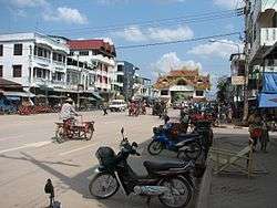
Main Street Looking East | |
 Myawaddy Location in Burma | |
| Coordinates: 16°41′16″N 98°30′30″E / 16.68778°N 98.50833°ECoordinates: 16°41′16″N 98°30′30″E / 16.68778°N 98.50833°E | |
| Country |
|
| Division | Kayin State |
| District | Myawaddy District |
| Township | Myawaddy Township |
| Population (2014) | 195,624 |
| • Religions | Buddhism |
| Time zone | MST (UTC+6.30) |
Myawaddy (Burmese: မြဝတီ) is a town in south-eastern Myanmar in Kayin State close to the border with Thailand. Separated from the Thai border town of Mae Sot by the Moei River ( Thaung Yinn River ), the town is most important trading point between Myanmar and Thailand.
On 6 August 2010, a bomb exploded in the car park of a crowded market in Myawaddy, killing two men and seriously injuring four others.[1]

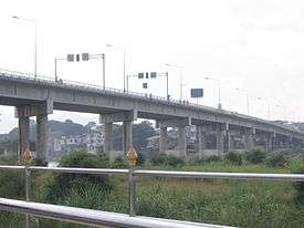
Friendship Bridge linking Myawaddy with Mae Sot.
Economy
The border-crossing is a major route for the export of Burma's gems,[2] many of which have their provenance changed once across the border.[3]
References
- ↑ http://www.irrawaddy.org/article.php?art_id=19164
- ↑ Chien, Choo Tse (2004) "Border Areas & Into Burma Photo Gallery" at pbase.com, archived here on 9 February 2005 by Internet Archive
- ↑ Naylor, Thomas (2009) "The underworld of gemstones Part II: in the eye of the beholder" Crime, Law and Social Change 53(3): 211–227, doi:10.1007/s10611-009-9221-1
External links
 Myawaddy travel guide from Wikivoyage
- "Myawadi Map — Satellite Images of Myawadi" at Maplandia
- "Myawaddy Photos: Pictures of Myawaddy, Myanmar", TravelPod
This article is issued from Wikipedia - version of the 9/29/2016. The text is available under the Creative Commons Attribution/Share Alike but additional terms may apply for the media files.

