Mutton Cove, Biscoe Islands
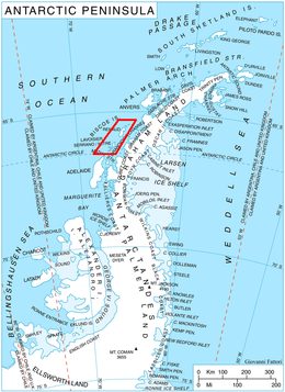
Location of Biscoe Islands in the Antarctic Peninsula region.
Mutton Cove (66°0′S 65°39′W / 66.000°S 65.650°WCoordinates: 66°0′S 65°39′W / 66.000°S 65.650°W) is an anchorage 0.5 nautical miles (0.9 km) northeast of the south end of Beer Island in the Biscoe Islands. The cove is formed by four small islands, Harp, Upper, Cliff and Girdler Islands. Beer Island shelters the cove from the west. Charted in 1936 by the British Graham Land Expedition (BGLE) under Rymill and, at the suggestion of Lieutenant R.G.D. Ryder, Royal Navy, captain of the days in a training ship at Devonport.
![]() This article incorporates public domain material from the United States Geological Survey document "Mutton Cove, Biscoe Islands" (content from the Geographic Names Information System).
This article incorporates public domain material from the United States Geological Survey document "Mutton Cove, Biscoe Islands" (content from the Geographic Names Information System).
This article is issued from Wikipedia - version of the 11/21/2015. The text is available under the Creative Commons Attribution/Share Alike but additional terms may apply for the media files.