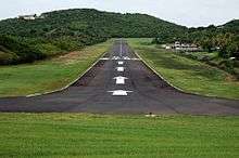
Mustique Airport
| Mustique Airport | |||||||||||
|---|---|---|---|---|---|---|---|---|---|---|---|
 | |||||||||||
| IATA: MQS – ICAO: TVSM | |||||||||||
| Summary | |||||||||||
| Airport type | Public | ||||||||||
| Owner | Mustique Company | ||||||||||
| Operator | Mustique Company | ||||||||||
| Location | Mustique, Saint Vincent and the Grenadines | ||||||||||
| Elevation AMSL | 8 ft / 2 m | ||||||||||
| Coordinates | 12°53′17″N 061°10′49″W / 12.88806°N 61.18028°WCoordinates: 12°53′17″N 061°10′49″W / 12.88806°N 61.18028°W | ||||||||||
| Website | http://mustique.com/ | ||||||||||
| Map | |||||||||||
 TVSM Location in Saint Vincent and the Grenadines | |||||||||||
| Runways | |||||||||||
| |||||||||||
Mustique Airport (IATA: MQS, ICAO: TVSM) is a private airfield owned by the Mustique Company, and is located on Mustique island, part of Saint Vincent and the Grenadines in the Caribbean Sea.
The airport has a short takeoff and landing (STOL) runway with a displaced threshold, thus limiting the aircraft types allowed to land. Single-engine light aircraft such as the Cessna 152, Cessna 172, and twin-engine light aircraft such as the Beechcraft King Air, the larger Beechcraft Super King Air or the well-known de Havilland Canada DHC-6 Twin Otter can easily land there.
For pilots not familiar with STOL, displaced thresholds, steep gradients at each end and a hill at one end of the runway, Mustique Airport can be a difficult airport to operate from.
The airport has no radio-navigational aids.
Airlines and destinations
| Airlines | Destinations |
|---|---|
| Mustique Airways | Barbados |
| SVG Air | Barbados, Bequia, Saint Vincent |
References
- ↑ Airport information for TVSM at World Aero Data. Data current as of October 2006.Source: DAFIF.
- ↑ Airport information for TVSM at Great Circle Mapper. Source: DAFIF (effective October 2006).