Musbury Castle
Coordinates: 50°44′31″N 3°01′01″W / 50.741949°N 3.017°W / 50.741949; -3.017
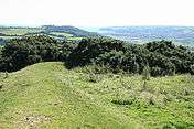
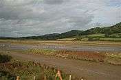
Musbury Castle is an Iron Age Hill fort situated above the Village of Musbury in Devon. The fort occupies a commanding hill top approx 175 Metres above Sea Level overlooking the Axe valley[1]at Ordnance Survey grid reference SY282941. Musbury means "mosses burough".
| Musbury Castle |
|---|
| Part of the fort and the view to Seaton on the South Devon coast. |
| Musbury Castle on the left of three hills viewed from the estuary of the river Axe |
|
References
- ↑ R.R.Sellman; Aspects of Devon History, Devon Books 1985 - ISBN 0-86114-756-1 - Chapter 2; The Iron Age in Devon. Map Page 11 of Iron Age hill forts in Devon includes Musbury


