Mossleigh
| Mossleigh | |
|---|---|
| Hamlet | |
|
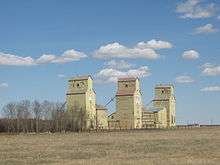
Mossleigh elevators. | |
| Coordinates: 50°43′13″N 113°19′28″W / 50.72028°N 113.32444°W | |
| Country |
|
| Province |
|
| Region | Southern Alberta |
| Census division | 5 |
| Municipal district | Vulcan County |
| Government | |
| • Governing body | Vulcan County Council |
| Time zone | MST (UTC-7) |
| Postal code span | List of T Postal Codes of Canada |
| Area code(s) | +1-403 |
| Highways | Highway 24 |
| Railways | Canadian Pacific |
Mossleigh is a hamlet in southern Alberta, Canada within Vulcan County.[1] It is located on Highway 24, approximately 63 kilometres (39 mi) southeast of Calgary.
Services

Mossleigh has a community hall, gas station/convenience store, a motel, and a restaurant.[2] The Mossleigh community school built in 1953 was closed in 1988 and is now privately owned. The former two room high school is also privately owned.[3]
Attractions
Mossleigh is home to a Lions Club campground,[4] while Aspen Crossing, located one kilometre west of Mossleigh, features a rail dining car with dinner theatre, a rail station with a gift store and a garden centre, and a campground with caboose cabins.[5] Mossleigh is also home to three wooden grain elevators. Two are owned by Cousins Ian and Eric Donovan and the third is currently owned by Parrish & Heimbecker Limited. [6] The town also has an active car club.[7]
See also
References
- ↑ Alberta Municipal Affairs (2010-04-01). "Specialized and Rural Municipalities and Their Communities" (PDF). Retrieved 2010-07-07.
- ↑ Mossleigh Bar n Grill. "Mossleigh Bar n Grill". Retrieved 2016-08-14.
- ↑ Vulcan County History (2010-09-20). "MOSSLEIGH SCHOOL NO. 4050". Retrieved 2016-08-14.
- ↑ Lions Club. "Mossleigh Lions Club". Retrieved 2016-08-14.
- ↑ "Aspen Crossing - Celebrating our Railroad Ties". Aspen Crossing. Retrieved 2012-05-28.
- ↑ Simon Ducatel - Vulcan Advocate (2012-03-26). "Mossleigh-area residents plan to maintain hamlet's row of three grain elevators". Retrieved 2016-08-14.
- ↑ Mossleigh Car Club. "Mossleigh Car Club". Retrieved 2016-08-14.
 |
Cheadle Carseland |
Strathmore | Cluny |  |
| Okotoks | |
Arrowwood | ||
| ||||
| | ||||
| Farrow | Herronton | Queenstown |
Coordinates: 50°43′13″N 113°19′28″W / 50.72028°N 113.32444°W
