Mittagberg
| Mittagberg | |
|---|---|
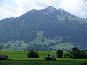 Mittagberg from the direction of Rettenberg (North-East) | |
| Highest point | |
| Elevation | 1,451 m (4,760 ft) Mittagberg |
| Prominence | 0.5 m (1.6 ft) Mittagberg |
| Coordinates | 47°42′10″N 10°12′56″E / 47.70278°N 10.21556°ECoordinates: 47°42′10″N 10°12′56″E / 47.70278°N 10.21556°E |
| Geography | |
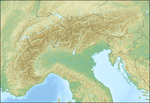 Mittagberg Location in the Alps | |
| Location | Bavaria, Germany |
| Parent range | Voralpen westlich der Iller, Allgäuer Alpen |
Mittagberg ("Midday mountain") is a high mountain located in the Allgäu Alps in Bavaria, Germany. Located just south of Immenstadt, this mountain is part of the Nagelfluhkette, and the Naturparks Nagelfluhkette. Its vertical separation is at least 31 meters,[1] meters, with a prominence of 500 meters when using the Bärenköpfle as reference.
Name
When looking at the mountain from Immenstadt, the sun at noon is right on top of the peak, giving it its name "Mittag" based on the German word for noon (mid day).
Routes
There are multiple Hiking trails that lead up to the peak of the mountain.
Alternative routes
There is a ski lift that goes from Immenstadt to the top, with one interruption approximately in the middle of the mountain. During the winter, more ski lifts open for skiing. A 5.1 km long toboggan run leads from the peak of the mountain to Immenstadt.
References
- ↑ Genauer Wert nicht bekannt, angegebener Wert ist ein Mindestwert (kann bis um 19 Meter höher sein). Ermittelt wurde er aus dem Abstand der Höhenlinien (20 Höhenmeter) in einer topografischen Karte (Maßstab 1:25.000).