Mastchoh District
| Mastchoh District | |
|---|---|
| District | |
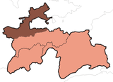
 Location of Mastchoh District in Tajikistan | |
| Country |
|
| Province | Sughd |
| Capital | Buston |
| Area | |
| • Total | 1,000 km2 (400 sq mi) |
| Population (2010) | |
| • Total | 101,313 |
| • Density | 100/km2 (260/sq mi) |
| Time zone | TJT (UTC+5) |
Mastchoh district or Nohiya-i Mastchoh (Tajik: Ноҳияи Мастчоҳ, Nohiya‘i Mastçoh/Nohijaji Mastcoh; Persian: ناحیۀ مستچاه) is a district in Sughd province, Tajikistan. It is located at the extreme north of the country, between Ghafurov district and the border with Uzbekistan.[1] The district population is 97,600 (1 January 2008 est.)[2] and its administrative capital is Buston (40°31′18″N 69°19′51″E / 40.52167°N 69.33083°E).
Administrative divisions
The district is divided administratively into jamoats. They are as follows (and population).[3]
| Jamoats of Mastchoh District | |||||||||||
| Jamoat | Population | ||||||||||
|---|---|---|---|---|---|---|---|---|---|---|---|
| Avzikent | 10373 | ||||||||||
| Mastchoh | 16401 | ||||||||||
| Obburdon | 27366 | ||||||||||
| Paldorak | 15680 | ||||||||||
| Takeli | 1643 | ||||||||||
| Buston | 10151 | ||||||||||
| Quruqsoy | 2729 | ||||||||||
References
- ↑ Republic of Tajikistan, map showing administrative division as of January 1, 2007, "Map Factory" Cartographic Press, Dushanbe
- ↑ Population of the Republic of Tajikistan as of 1 January 2008, State Committee of Statistics, Dushanbe, 2008 (Russian)
- ↑ "List of Jamoats". UN Coordination, Tajikistan. Retrieved April 4, 2009.
This article is issued from Wikipedia - version of the 6/26/2016. The text is available under the Creative Commons Attribution/Share Alike but additional terms may apply for the media files.

