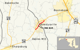
Maryland Route 845
| ||||
|---|---|---|---|---|
 | ||||
| Route information | ||||
| Maintained by MDSHA | ||||
| Length: | 1.23 mi[1] (1.98 km) | |||
| Existed: | 1961 – present | |||
| Major junctions | ||||
| South end: |
| |||
| North end: |
| |||
| Location | ||||
| Counties: | Washington | |||
| Highway system | ||||
| ||||
Maryland Route 845 (MD 845) is an unsigned state highway in the U.S. state of Maryland. Known for most of its length as Main Street, the state highway runs 1.23 miles (1.98 km) between intersections with MD 34 on either side of Keedysville in southern Washington County. MD 845, which is officially MD 845A, is the old alignment of MD 34 through Keedysville. The state highway was designated around 1960 when MD 34 bypassed the town.
Route description
MD 845 begins at an intersection with MD 34 (Shepherdstown Pike) just south of the town of Keedysville. Keedysville Road heads northwest on the opposite side of the intersection as a county highway that passes by Hills, Dales and The Vinyard, Hitt's Mill and Houses, and the Hoffman Farm. MD 845 heads southeast then immediately curves to the northeast as two-lane Main Street, entering the town limits and the Keedysville Historic District. The state highway intersects Dogstreet Road, which leads to the historic Geeting and Snively farms, before crossing over Little Antietam Creek. MD 845 intersects an abandoned Baltimore and Ohio Railroad grade before reaching an intersection with Keedy Drive on the north side of town. Main Street continues as a municipal street to a dead end while the state highway turns onto Keedy Drive to reach its northern terminus at MD 34.[1][2]
History
MD 845 is the old alignment of MD 34 through Keedysville. MD 34 was paved through the town by 1921.[3] MD 34 bypassed the town center and MD 845 was assigned to the old alignment around 1961.[4]
Junction list
The entire route is in Keedysville, Washington County.
| mi[1] | km | Destinations | Notes | ||
|---|---|---|---|---|---|
| 0.00 | 0.00 | Western terminus | |||
| 1.15 | 1.85 | Main Street north | MD 845 turns west onto Keedy Drive | ||
| 1.23 | 1.98 | Eastern terminus | |||
| 1.000 mi = 1.609 km; 1.000 km = 0.621 mi | |||||
See also
 Maryland Roads portal
References
- 1 2 3 Highway Information Services Division (December 31, 2013). Highway Location Reference. Maryland State Highway Administration. Retrieved 2010-11-16.
- Washington County (PDF)
- ↑ Google (2010-11-16). "Maryland Route 845" (Map). Google Maps. Google. Retrieved 2010-11-16.
- ↑ Maryland Geological Survey (1921). Map of Maryland: Showing State Road System and State Aid Roads (Map). Baltimore: Maryland Geological Survey.
- ↑ Maryland State Roads Commission (1961). Maryland: Official Highway Map (Map). Baltimore: Maryland State Roads Commission.
