Malankara Dam
| Malankara Dam | |
|---|---|
 | |
| Country | India |
| Location | Thodupuzha, Kerala, India |
| Coordinates | 9°51′10″N 76°44′41″E / 9.85278°N 76.74472°ECoordinates: 9°51′10″N 76°44′41″E / 9.85278°N 76.74472°E |
| Status | Operational |
| Dam and spillways | |
| Type of dam | Gravity concrete |
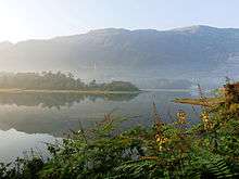
Malankara dam is a gravity dam constructed across Thodupuzha river for irrigation purposes. The dam is constructed to make use of the tail water from the Moolamattom power house. The project is run under the Muvattupuzha Valley Irrigation Project and KSEB. The artificial lake covers an area of around 11 km.
Tourism
Constructed across the Thodupuzha river for the purpose of irrigation, this reservoir is also a tourism spot.[1][2] This artificial lake is located near to the Thodupuzha – Moolamattom Road (State Highway 33)[3] covering an area of around 11 km. The reservoir is ideal for boating and fishing. [4] Unlike the Idukki and Cheruthoni dams, the Malankara dam is open to tourists round the year. Also a park is under construction nearby to the reservoir covering an adjacent 15 acre island.[5]
References
- ↑ https://www.keralatourism.org/destination/malankar-dam-thodupuzha/95
- ↑ http://www.visitorkerala.com/malankara-dam.html
- ↑ "Idukki district official website". Idukki District of Kerala - An Official Website. Retrieved 4 May 2016.
- ↑ "Idukki district official website". Idukki District of Kerala - An Official Website. Retrieved 4 May 2016.
- ↑ "The Hindu News Article". Malankara dam to be made a tourism spot- The Hindu. Retrieved 4 May 2016.