Magura (mountain)
| Magura | |
|---|---|
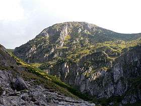 Magura viewed from Jaworzynka Valley | |
| Highest point | |
| Elevation | 1,704 m (5,591 ft) |
| Prominence | 42 m (138 ft) |
| Coordinates | 49°14′55″N 20°00′02″E / 49.24861°N 20.00056°ECoordinates: 49°14′55″N 20°00′02″E / 49.24861°N 20.00056°E |
| Geography | |
 Magura Location in Poland | |
| Parent range | Western Tatras |
Magura is a peak located in the Kasprowy Wierch massif, part of the Western Tatras in Poland. The peak is located between the Uhrocie Kasprowe and the Mała Kopa Królowa in the Western Tatras.[1]
The name of the peak originates from Vlachs - pastoral peoples, which introduced grazing to the Tatra Mountains. In their language, the name for the peak relates to a small, isolated peak. Formerly, the peak was named Kopa Jaworzyńska or Kopa, and was grazed on, being part of the Królowa Tundra. The slopes of the peak as a result of excess pasturage underwent strong erosion.[2] At present the flora has regrown on the peak, covering it with creeping pine and grassland.[3]
References
- ↑ Mirek, Halina Piękoś-Mirkowa, Zbigniew (2006). Rośliny chronione (Wyd. zmienione i poprawione. ed.). Warszawa: Oficyna Wydawnicza "Multico". ISBN 9788370734442.
- ↑ Paryski, Zofia Radwańska-Paryska, Witold Henryk (2004). Wielka encyklopedia tatrzańska. Poronin: Wydawnictwo Górskie. ISBN 8371040091.
- ↑ al.], red. Zbigniew Mirek, Halina Piękoś-Mirkowa ; [oprac. Instytut Botaniki im. W. Szafera PAN, Instytut Ochrony Przyrody PAN ; autorzy opracowań: Bartoszek Wacław et (2008). Czerwona księga Karpat Polskich : rośliny naczyniowe. Kraków: Instytut Botaniki im. W. Szafera PAN. ISBN 9788389648716.
This article is issued from Wikipedia - version of the 6/13/2016. The text is available under the Creative Commons Attribution/Share Alike but additional terms may apply for the media files.