Maginot Line
| Maginot Line | |
|---|---|
| Ligne Maginot | |
| Eastern France | |
|
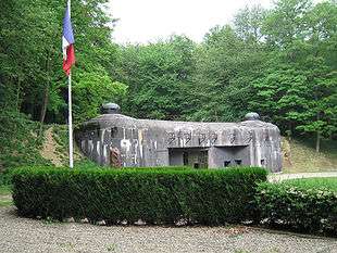
The entrance to Ouvrage Schoenenbourg along the Maginot Line in Alsace | |
| Type | Defensive line |
| Site information | |
| Controlled by | France |
| Open to the public | Yes |
| Condition | Mostly intact, through the preservation of the French Government |
| Site history | |
| Built | 1929–1938 |
| Built by |
Paul Painlevé, Colonel Tricaud
|
| In use | 1935–1969 |
| Materials | Concrete, steel, iron |
| Battles/wars |
|
The Maginot Line (French: Ligne Maginot, IPA: [liɲ maʒino]), named after the French Minister of War André Maginot, was a line of concrete fortifications, obstacles and weapon installations that France constructed on the French side of its borders with Switzerland, Germany and Luxembourg during the 1930s. The line did not extend through to the English Channel because the French military did not want to offend Belgium given its policy of neutrality. The line was a response to France's experience in World War I and was constructed during the run-up to World War II, shortly after the Locarno Conference that gave rise to a fanciful and optimistic "Locarno spirit".
The French established the fortification to give their army time to mobilize in the event of attack, and allow French forces to move into Belgium for a decisive confrontation with Germany. The success of static, defensive combat in World War I was a key influence on French thinking. French military experts extolled the Maginot Line as a work of genius, believing it would prevent any further invasions from the east.
The Maginot Line was impervious to most forms of attack, including aerial bombings and tank fire, and had underground railways as a backup; it also had state-of-the-art living conditions for garrisoned troops, supplying air conditioning and eating areas for their comfort.[1] Nevertheless, it proved strategically ineffective during the Battle of France. Instead of attacking directly, the Germans invaded through the Low Countries, bypassing the Line to the north. French and British officers had anticipated this: when Germany invaded the Netherlands and Belgium, they carried out plans to form an aggressive front that cut across Belgium and connected to the Maginot Line. However, the French line was weak near the Ardennes forest, a region whose rough terrain they considered unlikely for the Germans to traverse. The German Army took advantage of this weak point to split the French–British defensive front.[2] The Allied forces to the north were forced to evacuate at Dunkirk, leaving the forces to the south unable to mount an effective resistance to the German invasion of France.[3]
Planning and construction

The defences were first proposed by Marshal Joffre. He was opposed by modernists such as Paul Reynaud and Charles de Gaulle who favoured investment in armour and aircraft. Joffre had support from Marshal Henri Philippe Pétain, and there were a number of reports and commissions organised by the government. It was André Maginot who finally convinced the government to invest in the scheme. Maginot was another veteran of World War I; he became the French Minister of Veteran Affairs and then Minister of War (1928–1932).
In January 1923 after Germany defaulted on reparations, the French Premier Raymond Poincaré had French troops march in and occupy the Ruhr region of Germany in response. During the ensuing Ruhrkampf ("Ruhr struggle") between the Germans and the French that lasted until September 1923, Britain condemned the French occupation of the Ruhr, and a period of sustained Francophobia broke out in Britain, with Poincaré being vilified in Britain as a cruel bully punishing Germany with unreasonable reparations demands. The British—who openly championed the German position on reparations—applied intense economic pressure on France to change its policies towards Germany. At a conference in London in 1924 to settle the Franco-German crisis caused by the Ruhrkampf, the British Prime Minister Ramsay MacDonald successfully applied strong pressure on the French Premier Édouard Herriot to make concessions to Germany. The British diplomat Sir Eric Phipps who attended the conference commented afterwards that:
The London Conference was for the French 'man in the street' one long Calvary as he saw M. Herriot abandoning one by one the cherished possessions of French preponderance on the Reparations Commission, the right of sanctions in the event of German default, the economic occupation of the Ruhr, the French-Belgian railroad Régie, and finally, the military occupation of the Ruhr within a year.[4]
The great conclusion that was drawn in Paris after the Ruhrkampf and the 1924 London conference was that France could not make unilateral military moves to uphold Versailles as the resulting British hostility to such moves were too dangerous to the republic. Beyond that, the French were well aware of the contribution of Britain and its Dominions to the victory of 1918, and French decision-makers believed that they needed Britain's help to win another war; the French could only go so far with alienating the British.[5] From 1871 onwards, French elites had concluded that France had no hope of defeating Germany on its own, and France would need an alliance with another great power to defeat the Reich.[6]
1927: Allied Control Commission abolished
In 1927, the Allied Control Commission, which was responsible for ensuring that Germany complied with Part V of the Treaty of Versailles, was abolished as a goodwill gesture reflecting the "Spirit of Locarno".[7] When the Control Commission was dissolved, the commissioners in their final report issued a blistering statement, stating that Germany had never sought to abide by Part V and the Reichswehr had been engaging in covert rearmament all through the 1920s. Under the Treaty of Versailles France was to occupy the Rhineland region of Germany until 1935, but in fact the last French troops left the Rhineland in June 1930 in exchange for Germany accepting the Young Plan.[8] As long as the Rhineland was occupied by the French, the Rhineland served as a type of collateral under which the French would annex the Rhineland in the event of Germany breaching any of the articles of the treaty, such as rearming in violation of Part V; this threat was powerful enough to deter successive German governments all through the 1920s from attempting any overt violation of Part V.[9] French plans as developed by Marshal Ferdinand Foch in 1919 were based on the assumption that in the event of a war with the Reich, the French forces in the Rhineland were to embark upon an offensive to seize the Ruhr.[9] A variant of the Foch plan had been used by Poincaré in 1923 when he ordered the French occupation of the Ruhr.[9] French plans for an offensive in the 1920s were realistic, as Versailles had forbidden Germany conscription, and the Reichswehr was limited to 100,000 men. Once the French forces left the Rhineland in 1930, this form of leverage with the Rhineland as collateral was no longer available to Paris, which from then on had to depend on Berlin's word that it would continue to abide by the terms of the Versailles and Locarno treaties, which stated that the Rhineland was to stay demilitarized forever.[9] Given that Germany had engaged in covert rearmament with the co-operation of the Soviet Union starting in 1921 (a fact that become public knowledge in 1926) and that every German government had gone out of its way to insist on the moral invalidity of Versailles, claiming it was based upon the so-called Kriegsschuldlüge ("War guilt lie") that Germany started the war in 1914, the French had little faith that the Germans would willingly allow the Rhineland's demilitarized status to continue forever, and believed that at some time in the future Germany would rearm in violation of Versailles, reintroduce conscription and remilitarize the Rhineland.[9] The decision to build the Maginot Line in 1929 was a tacit French admission that without the Rhineland as collateral Germany was soon going to rearm, and that the terms of Part V had a limited lifespan.[9]
German economic superiority
After 1918, the German economy was three times as large as that of France; Germany had a population of 70 million compared to France's 40 million and the French economy was hobbled by the need to reconstruct the enormous damage of World War I, while German territory had seen little fighting. French military chiefs were dubious about their ability to win another war against Germany on its own, especially an offensive war.[9] French decision-makers knew that the victory of 1918 had been achieved because the British Empire and the United States were allies in the war and that the French would have been defeated on their own.[8] With the United States isolationist and Britain stoutly refusing to make the "continental commitment" to defend France on the same scale as in World War I, the prospects of Anglo-American assistance in another war with Germany appeared to be doubtful at best.[8] Versailles did not call for military sanctions in the event of Germany remilitarizing the Rhineland or breaking Part V; while Locarno committed Britain and Italy to come to French aid in the event of a "flagrant violation" of the Rhineland's demilitarized status, without defining "flagrant violation".[9] The British and Italian governments refused in subsequent diplomatic talks to define "flagrant violation", which led the French to place little hope in Anglo-Italian help if Germany should remilitarize the Rhineland.[9] Given the diplomatic situation in the late 1920s, the Quai d'Orsay informed the government that French military planning should be based on a worst-case scenario that France would fight the next war against Germany, without the help of Britain or the United States.[9]
France had an alliance with Belgium and with the states of the Cordon sanitaire, as the French alliance system in Eastern Europe was known. Although the alliances with Belgium, Poland, Czechoslovakia, Romania and Yugoslavia were appreciated in Paris, it was widely understood that this was no compensation for the absence of Britain and the United States. The French military was especially insistent that the population disparity made an offensive war of maneuver and swift advances suicidal as there would always be far more German divisions; a defensive strategy was needed to counter Germany.[9] The French assumption was always that Germany would not go to war without conscription, which would allow the German Army to take advantage of the Reich's numerical superiority. Without the natural defensive barrier provided by the Rhine river, French generals argued that France needed a new defensive barrier made of concrete and steel to replace it.[9] The power of properly dug-in defensive trenches had been amply demonstrated during World War I, when a few soldiers manning a single machine gun post could kill hundreds of the enemy in the open and therefore building a massive defensive line with subterranean concrete shelters was the most rational use of French manpower.[10]
The American historian William Keylor wrote that given the diplomatic conditions of 1929 and likely trends, the decision to build the Maginot Line was not irrational and stupid, building the Maginot Line was a sensible response to the problems that would be created by the coming French withdrawal from the Rhineland in 1930.[10] Part of the rationale for the Maginot Line stemmed from the severe French losses during the First World War, and their effect on the French population.[11] The drop in the birth rate during and after the war, resulting in a national shortage of young men, created an "echo" effect in the generation that provided the French conscript army in the mid-1930s.[11] Faced with a manpower shortage, French planners had to rely more on older and less fit reservists, who would take longer to mobilize and would diminish French industry because they would leave their jobs. Static defensive positions were therefore intended not only to buy time but to economise on men by defending an area with fewer and less mobile forces. In 1940, France deployed about twice as many men, 36 divisions (roughly one third of its force), for the defence of the Maginot Line in Alsace and Lorraine, whereas the opposing German Army Group C only contained 19 divisions, fewer than a seventh of the force committed in the Manstein Plan for the invasion of France.[12] Reflecting memories of World War I, the French General Staff had developed the concept of la puissance du feu ("the power of fire"), the power of artillery dug in and sheltered by concrete and steel, to inflict devastating losses on an attacking force.[13]
War of long duration
French planning for war with Germany was always based on the assumption that the war would be la guerre de longue durée (the war of the long duration), in which the superior economic resources of the Allies would gradually grind the Germans down.[14] The fact that the Wehrmacht embraced the strategy of Blitzkrieg (Lightning War) with the vision of swift wars in which Germany would win quickly via a knock-out blow, was a testament to the fundamental soundness of the concept of la guerre de longue durée.[14] Germany had the largest economy in Europe but lacked many of the raw materials necessary for a modern industrial economy (making the Reich vulnerable to a blockade) and the ability to feed its population. The guerre de longue durée strategy called for the French to halt the expected German offensive meant to give the Reich a swift victory; afterwards, there would be an attrition struggle; once the Germans were exhausted France would begin an offensive to win the war.[14]
The Maginot Line was intended to block the main German blow if it should come in eastern France and to divert the main blow through Belgium, where French forces would meet and stop the Germans.[15] The Germans were expected to fight costly offensives, whose failures would sap the strength of the Reich, while the French waged a total war with the resources of France, its empire and allies mobilized for the war.[16] Besides the demographic reasons, a defensive strategy served the needs of French diplomacy towards Great Britain.[17] The French imported a third of their coal from Britain and 32 percent of all imports through French ports were carried by British ships.[17] Of French trade, 35 percent was with the British Empire and the majority of the tin, rubber, jute, wool and manganese used by France came from the British Empire.[17]
About 55 percent of overseas imports arrived in France via the Channel ports of Calais, Le Havre, Cherbourg, Boulogne, Dieppe, Saint-Malo and Dunkirk.[17] Germany had to import most of its iron, rubber, oil, bauxite, copper and nickel, making naval blockade a devastating weapon against the German economy.[18] For economic reasons, the success of the strategy of la guerre de longue durée would at very least require Britain to maintain a benevolent neutrality, preferably to enter the war as an ally as British sea power could protect French imports while depriving Germany of hers. A defensive strategy based on the Maginot Line was an excellent way of demonstrating to Britain that France was not an aggressive power and would only to go to war in the event of German aggression, a situation that would make it more likely that Britain would enter the war on France's side.[19]
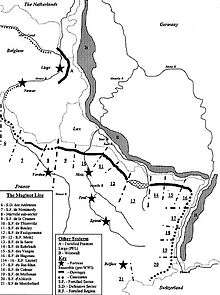
The line was built in several phases from 1930 by the Service Technique du Génie (STG) overseen by Commission d'Organisation des Régions Fortifiées (CORF). The main construction was largely completed by 1939, at a cost of around 3 billion French francs. The line stretched from Switzerland to Luxembourg and a much lighter extension was extended to the Strait of Dover after 1934. The original construction did not cover the area chosen by the Germans for their first challenge, which was through the Ardennes in 1940, a plan known as Fall Gelb (Case Yellow), due to the neutrality of Belgium. The location of this attack, because of the Maginot Line, was through the Belgian Ardennes forest (sector 4), which is off the map to the left of Maginot Line sector 6 (as marked).
Purposes
The Maginot Line was built to fulfil several purposes:
- To avoid a surprise attack and to give the alarm
- To cover the mobilisation of the French Army (which took between two and three weeks)
- To save manpower (France counted 39 million inhabitants, Germany 70 million)
- To protect Alsace and Lorraine (returned to France in 1918) and their industrial basin
- To be used as a basis for a counter-offensive
- To push the enemy to circumvent it while passing by Switzerland or Belgium
- To hold the enemy while the main army could be brought up to reinforce the line
- To show non-aggressive posture, and compel the British to help France if Germany invaded Belgium
- To push Belgium into the war, by leaving it open to an attack from Germany
Manning
Maginot Line fortifications were manned by specialist units of fortress infantry, artillery and engineers. The infantry manned the lighter weapons of the fortresses, and formed units with the mission of operating outside if necessary. Artillery troops operated the heavy guns and the engineers were responsible for maintaining and operating other specialist equipment, including all communications systems. All these troops wore distinctive uniform insignia and considered themselves among the elite of the French Army. During peacetime, fortresses were only partly manned by full-time troops. They would be supplemented by reservists who lived in the local area, and who could be quickly mobilised in an emergency.[20]
Full-time Maginot Line troops were accommodated in barracks built close by the fortresses. They were also accommodated in complexes of wooden housing adjacent to each fortresses, which were more comfortable than living inside, but which were not expected to survive wartime bombardment.[21]
Training was carried out at a fortress near the town of Bitche, This particular one was built in a military training area and could carry out live firing exercises. This was impossible elsewhere as the other parts of the line were located in civilian areas.[21]
Organization
Although the name "Maginot Line" suggests a rather thin linear fortification, it was quite deep, varying (i.e., from the border to the rear area) from 20–25 kilometres (12–16 miles). It was composed of an intricate system of strong points, fortifications and military facilities such as border guard posts, communications centres, infantry shelters, barricades, artillery, machine gun and anti-tank gun emplacements, supply depots, infrastructure facilities and observation posts. These various structures reinforced a principal line of resistance made up of the most heavily armed ouvrages, which can be roughly translated as fortresses or big defensive works.
From front to rear, (east to west) the line was composed of:
1. Border Post line: This consisted of blockhouses and strong houses, which were often camouflaged as inoffensive residential homes, built within a few metres of the border and manned by troops so as to give the alarm in the event of a surprise attack and to delay enemy tanks with prepared explosives and barricades.
2. Outpost and Support Point line: Approximately 5 km (3 mi) behind the border, a line of anti-tank blockhouses that were intended to provide resistance to armoured assault, sufficient to delay the enemy so as to allow the crews of the C.O.R.F. ouvrages to be ready at their battle stations. These outposts covered the main passages within the principal line.
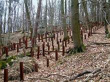
3. Principal line of resistance: This line began 10 km (6 mi) behind the border. It was preceded by anti-tank obstacles made of metal rails planted vertically in six rows, with heights varying from 0.70–1.40 metres (2 ft 4 in–4 ft 7 in) and buried to a depth of 2 m (6 ft 7 in). These anti-tank obstacles extended from end to end in front of the main works, over hundreds of kilometers, interrupted only by extremely dense forests, rivers, or other nearly impassable terrain.
- The anti-tank obstacle system was followed by an anti-personnel obstacle system made primarily of dense barbed wire. Anti-tank road barriers also made it possible to block roads at necessary points of passage through the tank obstacles.
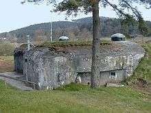
4. Infantry Casemates: These bunkers were armed with twin machine-guns (abbreviated as JM — Jumelage de mitrailleuses — in French) and anti-tank guns of 37 or 47 mm (1.5 or 1.9 in). They could be single (with a firing room in one direction) or double (two firing rooms, in opposite directions). These generally had two floors, with a firing level and a support/infrastructure level that provided the troops with rest and services (power generating units, reserves of water, fuel, food, ventilation equipment, etc.). The infantry casemates often had one or two "cloches" or turrets located on top of them. These GFM cloches were sometimes used to emplace machine guns or observation periscopes. They were manned by 20 to 30 men.
5. Petits ouvrages: These small fortresses reinforced the line of infantry bunkers. The petits ouvrages were generally made up of several infantry bunkers, connected by an underground tunnel network with attached underground facilities, such as barracks, electric generators, ventilation systems, mess halls, infirmaries and supply caches. Their crew consisted of between 100 and 200 men.
6. Ouvrages: These fortresses were the most important fortifications on the Maginot Line, having the sturdiest construction and the heaviest artillery. These were composed of at least six "forward bunker systems" or "combat blocks", as well as two entrances, and were connected via a network of underground tunnels that often featured narrow gauge electric railways for transport between bunker systems. The blocks contained infrastructure such as power stations, independent ventilating systems, barracks and mess halls, kitchens, water storage and distribution systems, hoists, ammunition stores, workshops and stores of spare parts and food. Their crews ranged from 500 to more than 1,000 men.
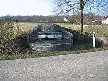
7. Observation Posts were located on hills that provided a good view of the surrounding area. Their purpose was to locate the enemy and direct and correct the indirect fire of artillery as well as to report on the progress and position of key enemy units. These are large reinforced buried concrete bunkers, equipped with armoured turrets containing high-precision optics, connected with the other fortifications by field telephone and wireless transmitters (known in French by the acronym T.S.F., Télégraphie Sans Fils).
8. Telephone Network: This system connected every fortification in the Maginot Line, including bunkers, infantry and artillery fortresses, observation posts and shelters. Two telephone wires were placed parallel to the line of fortifications, providing redundancy in the event of a wire getting cut. There were places along the cable where dismounted soldiers could connect to the network.
9. Infantry Reserve Shelters: These were found from 500–1,000 m (1,600–3,300 ft) behind the principal line of resistance. These were buried concrete bunkers designed to house and shelter up to a company of infantry (200 to 250 men) and had such features as electric generators, ventilation systems, water supplies, kitchens and heating, which allowed their occupants to hold out in the event of an attack. They could also be used as a local headquarters and as a base for counter-attacks.
10. Flood Zones were natural basins or rivers that could be flooded on demand and thus constitute an additional obstacle in the event of an enemy offensive.
11. Safety Quarters were built near the major fortifications so fortress (ouvrage) crews could reach their battle stations in the shortest possible time in the event of a surprise attack during peacetime.
12. Supply depots.
13. Ammunition dumps.
14. Narrow Gauge Railway System: A network of 600 mm (1 ft 11 5⁄8 in) narrow gauge railways was built so as to rearm and resupply the main fortresses (ouvrages) from supply depots up to 50 km (31 mi) away. Petrol-engined armoured locomotives pulled supply trains along these narrow-gauge lines. (A similar system was developed with armored steam engines back in 1914–1918.)
15. High-voltage Transmission Lines, initially above-ground but then buried, and connected to the civil power grid, provided electric power to the many fortifications and fortresses.
16. Heavy rail artillery was hauled in by locomotives to planned locations to support the emplaced artillery located in the fortresses, which was intentionally limited in range to 10–12 km (6–7 mi).
Inventory
Ouvrages
There are 142 ouvrages, 352 casemates, 78 shelters, 17 observatories and around 5,000 blockhouses in the Maginot Line.[22]
Armoured cloches
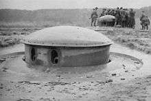
There are several kinds of armoured cloches. The word cloche is a French term meaning bell due to its shape. All cloches were made in an alloy steel. Cloches are non-retractable turrets.
- The most widespread are the GFM cloches, where GFM means Guetteur fusil-mitrailleur (machine-gun sentry). They are composed of three to four openings, called crenels or embrasures. These crenels may be equipped as follows: Rifle machine-gun, direct vision block, binoculars block or 50 mm (2.0 in) mortar. Sometimes, the cloche is topped by a periscope. There are 1,118 GFM cloches on the line. Almost every block, casemate and shelter is topped by one or two GFM cloches.
- The JM cloches (jumelage de mitrailleuses or "twin machine-guns") are the same as the GFM cloches except that they have one opening equipped with a pair of machine-guns. There are 174 JM cloches on the line.
- There are 72 AM cloches (armes mixtes or "mixed weapons") on the line, equipped with a pair of machine guns and a 25 mm (1.0 in) anti-tank gun. Some GFM cloches were transformed into AM cloches in 1934. (The aforementioned total does not include these modified cloches.)
- There are 75 LG cloches (lance-grenade or "grenade launcher") on the line. Those cloches are almost completely covered by concrete, with only a small hole to launch grenades through for local defence.
- There are 20 VP cloches (vision périscopique or "periscopic vision") on the line. These cloches could be equipped with several different periscopes. Like the LG cloches, they were almost completely covered by concrete.
- The VDP cloches (vision directe et périscopique or "direct and periscopic vision") are similar to the VP cloches, but have two or three openings to provide a direct view. Consequently, they were not covered by concrete.
 GFM cloche
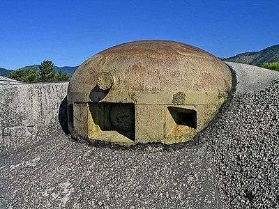 JM cloche
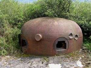 AM cloche
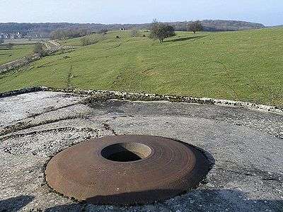 LG cloche
 VP cloche
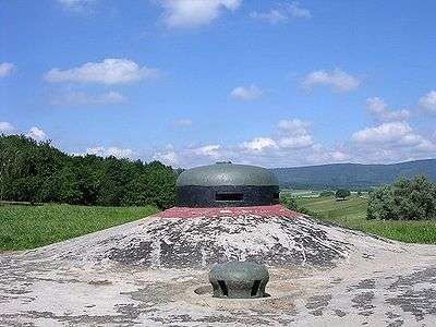 VDP cloche
Retractable turrets
The line included the following retractable turrets.
- 21 turrets of 75 mm (3.0 in) model 1933
- 12 turrets of 75 mm (3.0 in) model 1932
- 1 turret of 75 mm (3.0 in) model 1905
- 17 turrets of 135 mm (5.3 in)
- 21 turrets of 81 mm (3.2 in)
- 12 turrets for mixed weapons (AM)
- 7 turrets for mixed weapons + mortar of 50 mm (2.0 in)
- 61 turrets of machine-guns
- 75 mm (3.0 in) Turret model 1932
- 135 mm (5.3 in) Turret
- 81 mm (3.2 in) Turret
 Machine-gun Turret
- AM (Mixed-Weapons) Turret
Artillery
Both static and mobile artillery units were assigned to defend the Maginot Line. Régiments d’ artillerie de position (RAP) consisted of static artillery units. Régiments d’ artillerie mobile de forteresse (RAMF) consisted of mobile artillery.[23]
Anti-tank guns
Features
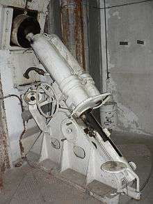
The specification of the defenses was very high, with extensive and interconnected bunker complexes for thousands of men; there were 45 main forts (grands ouvrages) at intervals of 15 km (9.3 mi), 97 smaller forts (petits ouvrages) and 352 casemates between, with over 100 km (62 mi) of tunnels. Artillery was coordinated with protective measures to ensure that one fort could support the next in line by bombarding it directly without harm. The largest guns were therefore 135 mm (5.3 in) fortress guns; larger weapons were to be part of the mobile forces and were to be deployed behind the lines.
The fortifications did not extend through the Ardennes Forest (which was believed to be impenetrable by Commander-in-Chief Maurice Gamelin) or along France's border with Belgium, because the two countries had signed an alliance in 1920, by which the French army would operate in Belgium if the German forces invaded. However, after France had failed to counter Germany's remilitarisation of the Rhineland, Belgium—thinking that France was not a reliable ally—abrogated the treaty in 1936 and declared neutrality. France quickly extended the Maginot Line along the Franco-Belgian border, but not to the standard of the rest of the line. As the water table in this region is high, there was the danger of underground passages getting flooded, which the designers of the line knew would be difficult and expensive to overcome.
In 1939 US Army officer Kenneth Nichols visited the Metz sector, where he was impressed by the formidable formations which he thought the Germans would have to outflank by driving through Belgium. In discussion with General Brousseau the commander of the Metz sector and other officers, the general outlined the French problem in extending the line to the sea in that placing the line along the Belgian-German border required the agreement of Belgium, but putting the line along the French-Belgian border relinquished Belgium to the Germans. Another complication was Holland, and the various governments never resolved their problems.[24]
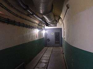
When the British Expeditionary Force landed in France in September 1939, they and the French reinforced and extended the Maginot line to the sea in a flurry of construction from 1939–1940 accompanied by general improvements all along the line. The final line was strongest around the industrial regions of Metz, Lauter and Alsace, while other areas were in comparison only weakly guarded. In contrast, the propaganda about the line made it appear far greater a construction than it was; illustrations showed multiple stories of interwoven passages and even underground railyards and cinemas. This reassured Allied civilians.
Czechoslovak connection
Czechoslovakia was also in fear of Hitler and began building its own defenses. As an ally of France, they were able to get advice on the Maginot design and apply it to Czechoslovak border fortifications. The design of the casemates is similar to the ones found in the southern part of the Maginot Line and photographs of them are often confused with Maginot forts. Following the Munich Agreement and the German occupation of Czechoslovakia, the Germans were able to use the Czech fortifications to plan attacks that proved successful against the western fortifications (the Belgian Fort Eben-Emael is the best known example).
German invasion in World War II
_bloc_1.jpg)
The World War II German invasion plan of 1940 (Sichelschnitt) was designed to deal with the line. A decoy force sat opposite the line while a second Army Group cut through the Low Countries of Belgium and the Netherlands, as well as through the Ardennes Forest, which lay north of the main French defences. Thus the Germans were able to avoid a direct assault on the Maginot Line by violating the neutrality of Belgium, Luxembourg and the Netherlands. Attacking on 10 May, German forces were well into France within five days and they continued to advance until 24 May, when they stopped near Dunkirk.
During the advance to the English Channel, the Germans overran France's border defence with Belgium and several Maginot Forts in the Maubeuge area, whilst the Luftwaffe simply flew over it. On 19 May, the German 16th Army successfully captured the isolated petit ouvrage La Ferté (southeast of Sedan) after conducting a deliberate assault by combat engineers backed up by heavy artillery. The entire French crew of 107 soldiers was killed during the action. On 14 June 1940, the day Paris fell, the German 1st Army went over to the offensive in "Operation Tiger" and attacked the Maginot Line between St. Avold and Saarbrücken. The Germans then broke through the fortification line as defending French forces retreated southward. In the following days, infantry divisions of the 1st Army attacked fortifications on each side of the penetration; successfully capturing four petits ouvrages. The 1st Army also conducted two attacks against the Maginot Line further to the east in northern Alsace. One attack successfully broke through a weak section of the line in the Vosges Mountains, but a second attack was stopped by the French defenders near Wissembourg. On 15 June, infantry divisions of the German 7th Army attacked across the Rhine River in Operation "Small Bear", penetrating the defences deep and capturing the cities of Colmar and Strasbourg.
By early June the German forces had cut off the line from the rest of France and the French government was making overtures for an armistice, which was signed on 22 June in Compiègne. As the line was surrounded, the German Army attacked a few ouvrages from the rear, but were unsuccessful in capturing any significant fortifications. The main fortifications of the line were still mostly intact, a number of commanders were prepared to hold out, and the Italian advance had been successfully contained. Nevertheless, Maxime Weygand signed the surrender instrument and the army was ordered out of their fortifications, to be taken to POW camps.
When the Allied forces invaded in June 1944, the line, now held by German defenders, was again largely bypassed; fighting touched only portions of the fortifications near Metz and in northern Alsace towards the end of 1944. During the German offensive "Operation Nordwind" in January 1945, Maginot Line casemates and fortifications were utilized by Allied forces, especially in the region of Hatten-Rittershoffen, and some German units had been supplemented with flamethrower tanks in anticipation of this possibility.[25] At one point during the fighting, General Martin, commander of the IX Corps, was ordered to advance from the Maginot Line against a German division, and consequently locked the concrete bunkers and left the keys with a colleague. When his fellow commander's unit was ordered south to reinforce French cities, Martin was forced to retreat from his attack and found himself pursued by a German tank division, and locked out of his own fortifications. He had to employ French engineers and sappers to break into the bunkers, which were subsequently overrun by the Germans.[26]
After World War II

After the war the line was re-manned by the French and underwent some modifications. With the rise of the French independent nuclear weapons by 1960 the line became an expensive anachronism. Some of the larger ouvrages were converted to command centres. When France withdrew from NATO's military component (in 1966) much of the line was abandoned, with the NATO facilities turned back over to French forces and the rest of it auctioned-off to the public or left to decay.[27] A number of old fortifications have now been turned into wine cellars, a mushroom farm and even a disco. Besides that, a few private houses are built atop some of the blockhouses.[28]
_bloc_5.jpg)
Ouvrage Rochonvillers was retained by the French Army as a command centre into the 1990s, but was deactivated following the disappearance of the Soviet "threat". Ouvrage Hochwald is the only facility in the main line that remains in active service, as a hardened command facility for the French Air Force known as Drachenbronn Air Base.
In 1968 when scouting locations for On Her Majesty's Secret Service, producer Harry Saltzman used his French contacts to gain permission to use portions of the Maginot Line as SPECTRE headquarters in the film. Saltzman provided art director Syd Cain with a tour of the complex, but Cain said that not only would the location be difficult to light and film inside, but that artificial sets could be constructed at the studios for a fraction of the cost.[29] The idea was shelved.
See also
- Atlantic Wall
- Czechoslovak border fortifications
- List of Alpine Line ouvrages (works)
- List of Maginot Line ouvrages (works)
- Metaxas Line
- Siegfried Line
- Commission for Organising the Fortified Regions (CORF)
Notes
- ↑ Gravett, Christopher (2007). The History of Castles: Fortifications Around the World. Globe Pequot (via Google Books). p. 187. ISBN 1599211106. Retrieved 19 April 2013.
- ↑ Winston, Churchill. The Second World War. 2. HoughtonMifflin. ISBN 0395410568.
- ↑ Chelminski, Rudolph (June 1997). "The Maginot Line" (PDF). Smithsonian: 90–100. Archived from the original (PDF) on 2 December 2007. Retrieved 26 June 2012.
- ↑ Sally Marks, "The Myths of Reparations" pages 231-255 from Central European History, Volume 11, Issue # 3 1978 page 249.
- ↑ Young, Robert An Uncertain Idea of France, New York: Peter Lang, 2005 page 20.
- ↑ Smith, Leonard; Audoin-Rouzeau, Steéphane, & Becker, Annette France and the Great War, 1914–1918, Cambridge: Cambridge University Press, 2003 page 11
- ↑ Keylor, William The Twentieth-Century World, Oxford: Oxford University Press, 2001 page 121
- 1 2 3 Keylor, William The Twentieth-Century World, Oxford: Oxford University Press, 2001 pages 121-122
- 1 2 3 4 5 6 7 8 9 10 11 12 Keylor, William The Twentieth-Century World, Oxford: Oxford University Press, 2001 page 122
- 1 2 Keylor, William The Twentieth-Century World, Oxford: Oxford University Press, 2001 page 123
- 1 2 Young, Robert An Uncertain Idea of France, New York: Peter Lang, 2005 page 13.
- ↑ Frieser, Karl-Heinz (2005). The Blitzkrieg Legend. Naval Institute Press. p. 88. ISBN 978-1-59114-294-2.
- ↑ Young, Robert An Uncertain Idea of France, New York: Peter Lang, 2005 page 36.
- 1 2 3 Young, Robert An Uncertain Idea of France, New York: Peter Lang, 2005 page 35.
- ↑ Young, Robert An Uncertain Idea of France, New York: Peter Lang, 2005 pages 35–36.
- ↑ Young, Robert An Uncertain Idea of France, New York: Peter Lang, 2005 page 37.
- 1 2 3 4 Young, Robert An Uncertain Idea of France, New York: Peter Lang, 2005 page 40.
- ↑ Young, Robert An Uncertain Idea of France, New York: Peter Lang, 2005 page 33.
- ↑ Young, Robert An Uncertain Idea of France, New York: Peter Lang, 2005 pages 40–41.
- ↑ Allcorn (2003), p.43
- 1 2 Allcorn (2003), p.44
- ↑ There are 58 ouvrages, 311 casemates, 78 shelters, 14 observatories and around 4,000 blockhouses on the North-West and 84 ouvrages, 41 casemates, three observatories and around 1,000 blockhouses to the South-West.
- ↑ Romanych, Rupp, Marc, Martin (2010). Maginot Line 1940: Battles on the French Frontier. Oxford: Osprey Publishing. p. 19. ISBN 978-1846034992.
- ↑ Nichols, Kenneth D. (1987). The Road to Trinity: A Personal Account of How America’s Nuclear Policies Were Made. New York: William Morrow and Company. ISBN 0-688-06910-X.
- ↑ Zaloga, Steven J. (June 2010). Operation Nordwind 1945: Hitler's Last Offensive in the West. Osprey Publishing. 96 pages; ISBN 978-1-84603-683-5.
- ↑ Regan, Geoffrey (1991). The Guinness Book of Military Blunders. London: Guinness Publishing. ISBN 978-0-851-12961-7.
- ↑ Seramour, Michaël. "Histoire de la Ligne Maginot de 1945 à nos jours" (in French). Revue Historique des Armées. pp. 86–97. Retrieved 19 February 2010.
- ↑ Chelminski, Rudolph (June 1997, abstract). "The Maginot Line – It Is Known as a Great Military Blunder, But in Fact This Stout Network of Ingenious Bunkers Did What It Was Designed to Do". Smithsonian. Retrieved 17 March 2013.
- ↑ Cain, Syd (2005). Not Forgetting James Bond. Richmond: Reynolds and Hearn. ISBN 978-1-905-28703-1.
References
- Allcorn, William. The Maginot Line 1928–45. Oxford: Osprey Publishing, 2003. ISBN 1-84176-646-1.
- Kaufmann, J.E. and Kaufmann, H.W. Fortress France: The Maginot Line and French Defenses in World War II, Stackpole Books, 2006. ISBN 0-275-98345-5.
- Kaufmann, J.E., Kaufmann, H.W., Jancovič-Potočnik, A. and Lang, P. The Maginot Line: History and Guide, Pen and Sword, 2011. ISBN 978-1-84884-068-3.
- Mary, Jean-Yves; Hohnadel, Alain; Sicard, Jacques. Hommes et Ouvrages de la Ligne Maginot, Tome 1. (Men and Works of the Maginot Line). Paris, Histoire & Collections, 2001. ISBN 2-908182-88-2. (French)
- Mary, Jean-Yves; Hohnadel, Alain; Sicard, Jacques. Hommes et Ouvrages de la Ligne Maginot, Tome 2. Paris, Histoire & Collections, 2003. ISBN 2-908182-97-1. (French)
- Mary, Jean-Yves; Hohnadel, Alain; Sicard, Jacques. Hommes et Ouvrages de la Ligne Maginot, Tome 3. Paris, Histoire & Collections, 2003. ISBN 2-913903-88-6. (French)
- Mary, Jean-Yves; Hohnadel, Alain; Sicard, Jacques. Hommes et Ouvrages de la Ligne Maginot, Tome 4 – La fortification alpine. Paris, Histoire & Collections, 2009. ISBN 978-2-915239-46-1. (French)
- Mary, Jean-Yves; Hohnadel, Alain; Sicard, Jacques. Hommes et Ouvrages de la Ligne Maginot, Tome 5. Paris, Histoire & Collections, 2009. ISBN 978-2-35250-127-5. (French)
- Romanych, Marc; Rupp, Martin. Maginot Line 1940: Battles on the French Frontier. Oxford: Osprey, 2010. ISBN 978-1846034992.
Further reading
- Rowe, V. (1959). The Great Wall of France: The Triumph of the Maginot Line (1st ed.). London: Putnam. OCLC 773604722.
External links
| Wikimedia Commons has media related to Maginot Line. |
- (French) The Maginot Line (French/English/German/Italian)
- (French) Fortress of Schoenenbourg, (French/English/German/Italian)
- Maginot Line (requires Flash)
- Maginot Line at War, 1940
- The U.S. Army vs. The Maginot Line by Bryan J. Dickerson
- Maginot Line today
- (Czech) Armament of Maginot Line (Czech only)
