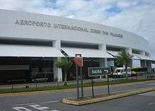
Zumbi dos Palmares International Airport
| Maceió/Zumbi dos Palmares International Airport Aeroporto Internacional Maceió/Zumbi dos Palmares | |||||||||||
|---|---|---|---|---|---|---|---|---|---|---|---|
 | |||||||||||
| IATA: MCZ – ICAO: SBMO | |||||||||||
| Summary | |||||||||||
| Airport type | Public | ||||||||||
| Operator | Infraero | ||||||||||
| Serves | Maceió | ||||||||||
| Elevation AMSL | 118 m / 347 ft | ||||||||||
| Coordinates | 09°31′02″S 035°47′01″W / 9.51722°S 35.78361°WCoordinates: 09°31′02″S 035°47′01″W / 9.51722°S 35.78361°W | ||||||||||
| Website | Infraero MCZ | ||||||||||
| Map | |||||||||||
 MCZ Location in Brazil | |||||||||||
| Runways | |||||||||||
| |||||||||||
| Statistics (2015) | |||||||||||
| |||||||||||
Maceió/Zumbi dos Palmares International Airport (IATA: MCZ, ICAO: SBMO), formerly called Campo dos Palmares Airport, is the airport serving Maceió, Brazil. Since 16 December 1999 the airport is named after Zumbi dos Palmares (1645–1695) a leader and hero who fought for the freedom of slaves.[4]
It is operated by Infraero.
History
The airport complex underwent major works in 2005, in which the passenger terminal and apron were renovated and the runway was extended.
Airlines and destinations
Access
The airport is located 25 km (16 mi) from downtown Maceió.
See also
References
- ↑ "Estatísticas" (in Portuguese). Infraero. 2 February 2016. Retrieved 14 June 2016.
- ↑ "Airport Official Website" (in Portuguese). Infraero.
- ↑ "Lista de aeródromos públicos" (in Portuguese). ANAC.
- ↑ "Lei n˚9.911, de 15 de dezembro de 1999" (in Portuguese). Lei Direto. 16 December 1999. Retrieved 19 April 2011.
- ↑ http://www.routesonline.com/news/38/airlineroute/269526/latam-brasil-adds-new-routes-from-sao-paulo-congonhas-in-nw16/
External links
- Airport information for SBMO at World Aero Data. Data current as of October 2006.Source: DAFIF.
- Airport information for SBMO at Great Circle Mapper. Source: DAFIF (effective October 2006).
- Current weather for SBMO at NOAA/NWS
- Accident history for MCZ at Aviation Safety Network
- Zumbi dos Palmares International Airport Photo Archive at airliners.net
This article is issued from Wikipedia - version of the 12/4/2016. The text is available under the Creative Commons Attribution/Share Alike but additional terms may apply for the media files.