M-2 highway (Montenegro)
| |
|---|---|
| Magistralni put M-2 | |
 | |
| Route information | |
|
Part of | |
| Length: | 358.6 km (222.8 mi) |
| Existed: | 1971 – present |
| Major junctions | |
| West end: |
|
| |
| East end: |
|
| Location | |
| Municipalities: | Herceg Novi, Kotor, Budva, Bar, Podgorica, Kolašin, Mojkovac, Bijelo Polje, Berane, Rožaje |
| Highway system | |
| Highways in Montenegro | |
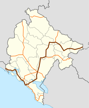
M-2 highway (Montenegrin: Magistralni put M-2) is a Montenegrin roadway.
The M-2 highway runs through many city centres, notably along the Montenegrin coast (i.e. Herceg Novi, Kotor, Budva), the Montenegrin capital (Podgorica), as well as throughout the north (i.e. Kolašin, Berane, Rožaje). Many of the main highways in Montenegro also have junctions along this highway. The M-2 highway is thus considered the "backbone of the Montenegrin road network".[1]
History
Construction on the M-2 highway began in 1953. Construction finished in 1971.[2]
On 27 March 2014, the Ministry of Transport and Maritime Affairs realigned the M-2 highway to its current alignment. Regional road R-22 was declared defunct and its route integrated into the M-2. As a result of the realignment, the M-2 no longer serves the Tivat Municipality. Instead, the Vrmac Peninsula (and thus the Tivat Municipality) is bypassed via the Vrmac Tunnel, connecting Radanovići to Kotor. The pre-realignment route from Radanovići and Lepetane (Ferryboat) was reassigned to the newly formed M-2.1 highway, while the remaining route between Lepetane and Škaljari was downgraded to a municipal road. [3]
Major intersections
| Municipality | Location | km | mi | Destinations | Notes |
|---|---|---|---|---|---|
| Herceg Novi | Debeli Brijeg | 0 | 0 | Border crossing with Croatia | |
| Kamenari | |||||
| Kotor | Lipci | ||||
| Škaljari | |||||
| Radanovići | |||||
| Budva | Bečići | ||||
| Petrovac na Moru | |||||
| Bar | Virpazar | ||||
| Bar / Podgorica | Kruševica / Vranjina | Bridge over Lake Skadar | |||
| Podgorica – Golubovci | Golubovci | ||||
| Podgorica | Podgorica – Zabjelo | Western terminus of M-18 concurrency Western terminus of E 762 concurrency | |||
| Podgorica – Stari Aerodrom | Eastern terminus of M-18 concurrency Eastern terminus of E 762 concurrency | ||||
| Bioče | |||||
| Kolašin | Mioska | ||||
| Kolašin | |||||
| Mojkovac | Mojkovac | ||||
| Bijelo Polje | Slijepač Most | ||||
| Ribarevine | |||||
| Berane | Berane | ||||
| Rožaje | Kalače | ||||
| Rožaje | |||||
| Most Zeleni | |||||
| Dračenovac | Border crossing with Serbia | ||||
1.000 mi = 1.609 km; 1.000 km = 0.621 mi
| |||||
References
- ↑ Doderović & Ivanović 2012, pp. 482–483: "Nајznаčајniјi је оd njih, svаkаkо, јаdrаnski put M-2, pоpulаrnо nаzvаn Јаdrаnskа mаgistrаlа, kоја prеdstаvljа kičmu putnе mrеžе Crnе Gоrе, јеr sе оd njе оdvајајu ili sа njom ukrštајu skоrо svi vаžniјi putni prаvci u zemlji. Оvај put pоvеzuје dеsеt оpštinskih cеntаrа u Crnој Gоri, а njimе sе Crnа Gоrа uključuје u mеđunаrоdnu putnu mrеžu."
- ↑ Doderović & Ivanović 2012, pp. 483: "Izgrаdnjа Јаdrаnskоg putа nа tеritоriјi Crnе Gоrе pоčеlа је 1953. gоdine а zаdnjа njеgоvа diоnicа zаvršеnа је 1971. gоdinе."
- ↑ "Informacija o prekategorizaciji dionica državnih puteva" [Information regarding the recategorisation of segments along national roads] (in Montenegrin). Government of Montenegro. 27 March 2014.
Regionalni put R-22 Kotor (Škaljari) – tunel „Vrmac“ – „Krtolska raskrsnica” prekategorisati u magistralni put M-2. [...] Dionica magistralnog puta M-2 Lepetani-Tivat- Krtolska raskrsnica” dobija oznaku M-2.1 [...] Dionicu magistralnog puta M-2, Stoliv-Lepetani(trajekt) prekategorisati u opštinski put (Opština Tivat).
Sources
- Doderović, Miroslav; Ivanović, Zdravko (Fall 2012), Drumski saobraćaj u Crnoj Gori [Vehicular transport in Montenegro] (PDF) (in Montenegrin), Matica crnogorska, retrieved 24 May 2015
