Listed buildings in Runcorn (rural area)
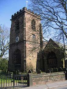
Runcorn is a small industrial town in the borough of Halton, Cheshire, England. This list contains the 27 buildings that are recorded in the National Heritage List for England as designated listed buildings in the part of the borough lying to the south of the River Mersey outside the urban area of Runcorn. The area covered includes the villages of Clifton, Daresbury, Preston Brook, Preston on the Hill, and Moore. Three of the buildings in the area are classified as Grade II*, and the others are at Grade II; there are no buildings in Grade I. In the United Kingdom, the term listed building refers to a building or other structure officially designated as being of special architectural, historical, or cultural significance. These buildings are in three grades: Grade I consists of buildings of outstanding architectural or historical interest; Grade II* includes particularly significant buildings of more than local interest; Grade II consists of buildings of special architectural or historical interest. Buildings in England are listed by the Secretary of State for Culture, Media and Sport on recommendations provided by English Heritage, which also determines the grading.[1]
Although the urban area of Runcorn grew rapidly during the Industrial Revolution, and again with the growth of the New Town during the 1960s and 1970s, the surrounding area, mainly to the west of the town, has experienced only a small growth in population. The villages are small and discrete, and are separated by farmland and woodland. The area covered by the list is crossed by roads, railways, and canals, with which some of the listed buildings are associated. The oldest of these are the canals: the Bridgewater Canal, the Trent and Mersey Canal, the Weaver Navigation and the Manchester Ship Canal. The railways consist of the West Coast Main Line – the section between Crewe and Warrington, and the branch to Liverpool – and the Chester-Manchester Line. The major roads are the M56 motorway and the A6 road, together with sections of the A533, the A557 and the A558 roads.
The ages of the structures on the list range from the ruin of Clifton Hall, built in 1565, to the telephone kiosk in Daresbury, which dates from the 1930s. The three Grade II* listed buildings include the only church in the list and two former mansion houses. The church and one of the mansion houses are in Daresbury, and the other mansion house is in Moore. Daresbury also contains a former sessions house. Moore reflects its rural past with two farmhouses and a number of cottages. Also in the village of Moore are a public house, a former school, and a bridge over the Bridgewater Canal. Preston Brook stands on the junction of the Bridgewater and the Trent and Mersey Canals; other than one listed house, the structures are associated with the canals – a former warehouse, a tunnel entrance, a milepost, and two air shafts. Other listed buildings are in more isolated sites and include another farmhouse, another canal bridge, a swing bridge over the Manchester Ship Canal, and a railway viaduct over the Weaver Navigation and A557 road.
Key
| Grade | Criteria[2] | ||||||||||||
|---|---|---|---|---|---|---|---|---|---|---|---|---|---|
| II* | Particularly important buildings of more than special interest | ||||||||||||
| II | Buildings of national importance and special interest | ||||||||||||
| "—" denotes a work that is not listed. | |||||||||||||
Listed buildings
| Name | Photograph | Grade | Date | Location | Description |
|---|---|---|---|---|---|
| All Saints' Church | 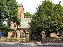 |
II* | 16th century and 1871 | Daresbury 53°20′26″N 2°37′52″W / 53.3406°N 2.6312°W |
The parish church of Daresbury was rebuilt in 1871, and retains its 16th-century tower. It is built in red sandstone with a slate roof. Lewis Carroll was born in the vicarage; a stained-glass window in the church depicts characters from his books.[3][4] |
| Moore Hall | 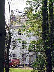 |
II* | Early 18th century | Moore 53°21′15″N 2°37′52″W / 53.3542°N 2.6311°W |
Built in rendered brick with a slate roof, this former mansion house has five bays and three storeys, rusticated quoins and a cornice at the second-floor level.[5][6] |
| Daresbury Hall | 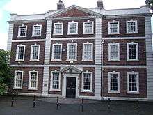 |
II* | 1759 | Daresbury 53°20′17″N 2°37′33″W / 53.3380°N 2.6257°W |
This former mansion house is built in brown brick with a slate roof in three storeys and three bays. It incorporates a stone plinth and floor bands, rusticated giant pilasters and matching stone quoins.[4][7] |
| Clifton Hall | 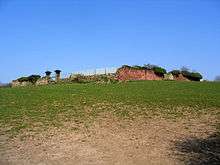 |
II | 1565 | Cholmondeley Road, Clifton 53°18′57″N 2°42′51″W / 53.3159°N 2.7141°W |
Once the second-largest house in Cheshire, this former Elizabethan mansion is now a ruin and only fragments of sandstone walling remain.[8][9][10] |
| Manor Farm House |  |
II | 1660 | 129 Runcorn Road, Moore 53°21′13″N 2°38′16″W / 53.3536°N 2.6379°W |
This former farm house has been heavily restored. It is constructed in sandstone, brick and timber framing, and has a tile roof. It is in two storeys and three bays, and has a west gabled projection.[11] |
| Village Farm House |  |
II | Late 17th century with later alterations | 128 Runcorn Road, Moore 53°21′13″N 2°38′14″W / 53.3537°N 2.6371°W |
Built in stone with a stone-slate roof in two storeys with an attic, this former farm house originally had four bays but the original window openings have been built up and new windows inserted.[6][12] |
| Red Lion public house | 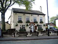 |
II | Late 17th century with later alterations | Runcorn Road, Moore 53°21′12″N 2°38′12″W / 53.3533°N 2.6366°W |
This public house is built in whitened brick with a slate roof in two storeys with bays. It has an arched entrance with a blank fanlight.[13] |
| Black Jane farm house |  |
II | 1729 | Newton Lane, Daresbury 53°19′22″N 2°36′22″W / 53.3228°N 2.6060°W |
This farm house is constructed in brown brick with a slate roof. It has two storeys and five bays with later additions. It includes stone flush quoins and a timber doorcase.[14] |
| Old Farm House Cottages |  |
II | 1758 | 110–112 Runcorn Road, Moore 53°21′13″N 2°38′08″W / 53.3535°N 2.6355°W |
Built in brown brick with a slate roof, this pair of cottages is in two storeys plus an attic with three bays. The original door to No. 112 has been replaced by a window that matches the others.[15] |
| George Gleave's bridge |  |
II | c. 1772 | Near Daresbury 53°20′13″N 2°38′47″W / 53.33705°N 2.64651°W |
This is an accommodation bridge connecting two fields, crossing the Bridgewater Canal. It is built in red brick with ashlar sandstone dressings and consists of a single-span segmental arch.[16] |
| Moore bridge |  |
II | c. 1772 | Moore 53°21′16″N 2°37′55″W / 53.3544°N 2.6319°W |
This is a road bridge over the Bridgewater Canal built in red brick with a stone carriageway and parapet. It is steeply humped and is wide enough for only one vehicle.[17] |
| Former warehouse | 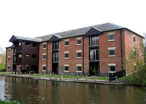 |
II | c. 1772 | Preston Brook 53°19′07″N 2°38′55″W / 53.3185°N 2.6485°W |
Standing alongside the Bridgewater Canal, this former warehouse is built in brick with a slate roof. It has been converted into residential use. It has three storeys with seven widely spaced window bays on the east side and four additional gabled loading bays on the west.[18] |
| Preston Brook Tunnel north entrance |  |
II | c. 1777 | Preston Brook 53°18′52″N 2°38′47″W / 53.3144°N 2.6463°W |
This is the entrance to the tunnel linking the south end of the Bridgewater Canal with the Trent and Mersey Canal. It is built in red brick with stone dressings.[19] |
| Canal air shaft (north) |  |
II | c. 1777 | Preston Brook 53°18′50″N 2°38′46″W / 53.3139°N 2.6460°W |
Located towards the northern end of the tunnel carrying the Trent and Mersey Canal, this is the top of an air shaft. It is circular, built in blue brick, 6 feet (2 m) in diameter, and 6 feet (2 m) high.[20] |
| Canal air shaft (south) |  |
II | c. 1777 | Preston Brook 53°18′40″N 2°38′41″W / 53.3112°N 2.6446°W |
Towards the southern end of the tunnel carrying the Trent and Mersey Canal, the top of this air shaft is circular, built in blue brick, 6 feet (2 m) in diameter, and 9 feet (3 m) high.[21] |
| Ivy Cottage |  |
II | Mid 18th century | 106 Runcorn Road, Moore 53°21′13″N 2°38′05″W / 53.3536°N 2.6348°W |
The house is constructed of brown brick with a slate roof in two storeys with three bays. It has a stone doorcase with Tuscan columns, and an open pediment with an arched blank tympanum.[22] |
| The Pebbles |  |
II | Mid 18th century | 109 Runcorn Road, Moore 53°21′12″N 2°38′09″W / 53.3533°N 2.6358°W |
This house is built in brown brick with a concrete tile roof in two storeys with three bays. It has a stone doorcase with Tuscan columns, and an open pediment with an arched blank tympanum. The opening for the centre window in the first floor is blank.[23] |
| Brook House |  |
II | Late 18th century | Preston Brook 53°19′17″N 2°39′01″W / 53.3215°N 2.6504°W |
In Gothic style, this cottage is built in whitened brick with a slate roof. It is in two storeys with four bays, plus one bay added to the south. The windows have lozenge glazing.[24] |
| Roselea and Briardene |  |
II | Late 18th century | Moss Lane, Moore 53°21′22″N 2°38′14″W / 53.3562°N 2.6373°W |
This pair of cottages is built in brown brick in two storeys with four bays. It has a roof of "very large" slates, and the original three-light horizontal-sliding sash windows are still present.[25] |
| Canal mile post | 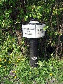 |
II | 1819 | Preston Brook 53°18′47″N 2°38′46″W / 53.313°N 2.646°W |
This is the mile post near the north end of the Trent and Mersey Canal showing the distance to the terminus at Shardlow as "92 miles" (which is 148 km). It is made in cast iron, painted black and white, and consists of a circular post with a moulded head and embossed letters on two convex tablets.[26] |
| Sessions house |  |
II | 1841 | Daresbury 53°20′27″N 2°37′59″W / 53.3408°N 2.6331°W |
This is a former sessions house that is now used by the adjoining public house. It is built in red brick with a slate roof, in one storey with three bays. The middle bay has a plastered recess containing a tablet with a Latin inscription giving the purpose and date of the building.[4][27] |
| Sutton Weaver viaduct |  |
II | 1848–50 | Clifton Road, Sutton Weaver 53°18′21″N 2°42′05″W / 53.3059°N 2.7014°W |
The Chester-Manchester railway line crosses the A557 road and the Weaver Navigation on this viaduct, which has a cast iron span and brick abutments.[28] |
| Former primary school |  |
II | 1878 | Moss Lane, Moore 53°21′17″N 2°38′09″W / 53.3547°N 2.6357°W |
This was a primary school built in brown brick with stone dressings and a stone slate roof. It is in a single storey with four bays in an "L" plan. In the front gable is a crest containing three carved birds.[29] |
| Swing bridge |  |
II | c. 1878 | Moore Lane, Moore 53°21′47″N 2°38′06″W / 53.3630°N 2.6351°W |
This swing bridge crosses the Manchester Ship Canal and is operated from the north bank by hydraulic water power. The support buildings are of red brickwork with slate roofs.[30] |
| Gate piers, gate and side walls |  |
II | 19th century | 128 Runcorn Road, Moore 53°21′13″N 2°38′14″W / 53.3536°N 2.6371°W |
The gate piers of Village Farm House are made from yellow sandstone. They are in Jacobean Revival style and hold a wrought iron screen with overthrows.[31] |
| War memorial | — |
II | 1920 | Daresbury 53°20′28″N 2°37′54″W / 53.34112°N 2.63162°W |
The war memorial is at an intersection of paths in the churchyard of All Saints' Church. It is in stone and consists of a tall, tapering, octagonal shaft carrying a blind wheel-head cross, each quarter of which is decorated with a carved fleur-de-lis. The base of the shaft is moulded and stands on an octagonal plinth on a base of four octagonal steps. On the plinth and steps are stones plaques with inscriptions and the names of those who were lost in both World Wars.[32] |
| Telephone kiosk |  |
II | 1935 | Chester Road, Daresbury 53°20′26″N 2°37′58″W / 53.340636°N 2.632830°W |
This type K6 telephone kiosk was designed by Sir Giles Gilbert Scott. It is made in cast iron and is painted red. It is included in the list because of its group value with All Saints' church and the sessions house.[33] |
See also
- List of listed buildings in Runcorn (urban area)
- Grade I listed buildings in Cheshire
- Grade II* listed buildings in Cheshire
References
Citations
- ↑ Listed buildings, English Heritage, retrieved 23 April 2011
- ↑ Listed Buildings, Historic England, retrieved 2 April 2015
- ↑ Historic England, "Church of All Saints, Daresbury (1130450)", National Heritage List for England, retrieved 2 April 2015
- 1 2 3 Hartwell et al. 2011, p. 325
- ↑ Historic England, "Moore Hall (1330357)", National Heritage List for England, retrieved 2 April 2015
- 1 2 Hartwell et al. 2011, p. 486
- ↑ Historic England, "Daresbury Hall (1330337)", National Heritage List for England, retrieved 2 April 2015
- ↑ Historic England, "Remains of Rocksavage (1330365)", National Heritage List for England, retrieved 2 April 2015
- ↑ Starkey, H. F. (1990), Old Runcorn, Halton Borough Council, pp. 73–77
- ↑ Hartwell et al. 2011, p. 291
- ↑ Historic England, "Manor Farm House, 129 Runcorn Road, Moore (1130431)", National Heritage List for England, retrieved 2 April 2015
- ↑ Historic England, "Village Farm House, 128 Runcorn Road, Moore (1330360)", National Heritage List for England, retrieved 2 April 2015
- ↑ Historic England, "The Red Lion Public House, Moore (1086982)", National Heritage List for England, retrieved 2 April 2015
- ↑ Historic England, "Black Jane Farm House (1130451)", National Heritage List for England, retrieved 2 April 2015
- ↑ Historic England, "Old Farm House Cottages, 110–112 Runcorn Road, Moore (1115463)", National Heritage List for England, retrieved 2 April 2015
- ↑ Historic England, "Bridgewater Canal George Gleave's Bridge (1248142)", National Heritage List for England, retrieved 2 April 2015
- ↑ Historic England, "Moore Bridge (1130427)", National Heritage List for England, retrieved 2 April 2015
- ↑ Historic England, "The Old Number One (1330363)", National Heritage List for England, retrieved 2 April 2015
- ↑ Historic England, "Preston Brook Tunnel Entrance (1104925)", National Heritage List for England, retrieved 2 April 2015
- ↑ Historic England, "Northern Air Shaft to Preston Brook Tunnel Entrance (1130435)", National Heritage List for England, retrieved 2 April 2015
- ↑ Historic England, "Preston Brook Tunnel air shaft north west of Talbot Arms public house (1248174)", National Heritage List for England, retrieved 2 April 2015
- ↑ Historic England, "Ivy Cottage, 106 Runcorn Road, Moore (1130429)", National Heritage List for England, retrieved 2 April 2015
- ↑ Historic England, "The Pebbles, 109 Runcorn Road, Moore (1330361)", National Heritage List for England, retrieved 2 April 2015
- ↑ Historic England, "Brook House, Preston Brook (1096857)", National Heritage List for England, retrieved 2 April 2015
- ↑ Historic England, "Roselea and Briardene cottages, Moore (1130428)", National Heritage List for England, retrieved 2 April 2015
- ↑ Historic England, "Trent and Mersey Canal canal milepost south of north entrance to Preston Brook Tunnel (1115837)", National Heritage List for England, retrieved 2 April 2015
- ↑ Historic England, "The Sessions House, Daresbury (1330336)", National Heritage List for England, retrieved 2 April 2015
- ↑ Historic England, "Frodsham Viaduct number 54 (1253269)", National Heritage List for England, retrieved 2 April 2015
- ↑ Historic England, "Moore Old Primary School (1330359)", National Heritage List for England, retrieved 2 April 2015
- ↑ Historic England, "Moore Lane Bridge l (1330358)", National Heritage List for England, retrieved 2 April 2015
- ↑ Historic England, "Gate piers, gate and sidewalls to Village Farmhouse. Moore l (1087010)", National Heritage List for England, retrieved 2 April 2015
- ↑ Historic England, "Daresbury War Memorial (1429154)", National Heritage List for England, retrieved 29 September 2015
- ↑ Historic England, "Telephone kiosk, Daresbury, at junction with Chester Road (1330356)", National Heritage List for England, retrieved 2 April 2015
Sources
- Hartwell, Clare; Hyde, Matthew; Hubbard, Edward; Pevsner, Nikolaus (2011) [1971], Cheshire, The Buildings of England, New Haven and London: Yale University Press, ISBN 978-0-300-17043-6
| Wikimedia Commons has media related to Runcorn. |