List of protected heritage sites in Yvoir
This table shows an overview of the protected heritage sites in the Walloon town Yvoir. This list is part of Belgium's national heritage.
| Object |
Year/architect |
Town/section |
Address |
Coordinates |
Number? |
Image |
|---|---|---|---|---|---|---|
| Mouth of the Bocq (nl) (fr) |
Yvoir | 50°19′32″N 4°52′37″E / 50.325690°N 4.876976°E |
91141-CLT-0002-01 Info |
|||
| Mill square (nl) (fr) |
Yvoir | Évrehailles | 50°19′34″N 4°54′45″E / 50.326091°N 4.912615°E |
91141-CLT-0003-01 Info |
||
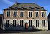
| Buildings belonging to the Seigneurie de Godinne, namely: the tower of Saint-Pierre Church, the castle in Spanish Renaissance style and the large farm, which is separated from the rest by the course of the Rouillon river, and the whole formed by the buildings and their sides. (nl) (fr) |
Yvoir | 50°21′00″N 4°51′59″E / 50.350126°N 4.866500°E |
91141-CLT-0004-01 Info |
 | ||
| Site of "Mont-sur-Meuse" <sup style="text-align:right; line-height:1em;
margin-left:0.3em; color:blue; cursor:help; font-family:Verdana,sans-serif;"
title="Site van "Mont-sur-Meuse"">(nl) (fr) |
Yvoir | 50°21′29″N 4°52′37″E / 50.358157°N 4.876888°E |
91141-CLT-0005-01 Info |
|||
| Spontin Castle, the farm and the whole thereof (nl) (fr) |
Yvoir | 50°19′25″N 5°00′28″E / 50.323519°N 5.007849°E |
91141-CLT-0006-01 Info |
 | ||
| Ruins of Poilvache Castle and the surroundings (nl) (fr) |
Yvoir | 50°18′24″N 4°53′32″E / 50.306751°N 4.892172°E |
91141-CLT-0007-01 Info |
.JPG) | ||
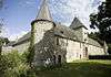
| Ruins of Poilvache Castle (nl) (fr) |
Yvoir | 50°18′20″N 4°54′03″E / 50.305451°N 4.900727°E |
91141-CLT-0008-01 Info |
.JPG) | ||
| Bois des Roches (nl) (fr) |
Yvoir | 50°20′21″N 4°54′21″E / 50.339257°N 4.905876°E |
91141-CLT-0009-01 Info |
|||
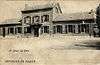
| Facade and roof of the station, this ensemble and its environment (nl) (fr) |
Yvoir | 50°20′56″N 4°52′08″E / 50.348873°N 4.869015°E |
91141-CLT-0010-01 Info |
 | ||
| Banks of the Meuse, to Tricointe (nl) (fr) |
Yvoir | 50°20′23″N 4°52′52″E / 50.339654°N 4.881218°E |
91141-CLT-0011-01 Info |
|||
| Valley of the Meuse between Bouvignes and Houx (nl) (fr) |
Yvoir | 50°16′25″N 4°53′49″E / 50.273744°N 4.896867°E |
91141-CLT-0012-01 Info |
|||
| Ruins of Poilvache Castle and surroundings (nl) (fr) |
Yvoir | 50°18′24″N 4°53′32″E / 50.306751°N 4.892172°E |
91141-PEX-0001-01 Info |
| ||
| Valley of the Meuse between Bouvignes and Houx (nl) (fr) |
Yvoir | 50°16′25″N 4°53′49″E / 50.273744°N 4.896867°E |
91141-PEX-0002-01 Info |
See also
| Wikimedia Commons has media related to Cultural heritage monuments in Yvoir. |
References
- Belgian heritage register: Direction générale opérationnelle - Aménagement du territoire, Logement, Patrimoine et Energie (DG4)
- www.dglive.be
This article is issued from Wikipedia - version of the 12/17/2015. The text is available under the Creative Commons Attribution/Share Alike but additional terms may apply for the media files.