List of protected heritage sites in Rochefort, Belgium
This table shows an overview of the protected heritage sites in the Walloon town Rochefort, Belgium. This list is part of Belgium's national heritage.
| Object |
Year/architect |
Town/section |
Address |
Coordinates |
Number? |
Image |
|---|---|---|---|---|---|---|
| Park of the old Hôtel des Roches (nl) (fr) |
Rochefort | 50°09′41″N 5°13′25″E / 50.161426°N 5.223650°E |
91114-CLT-0001-01 Info |
|||
| Whole of the house "Jacquet" <sup style="text-align:right; line-height:1em;
margin-left:0.3em; color:blue; cursor:help; font-family:Verdana,sans-serif;"
title="Geheel van het huis "Jacquet"">(nl) (fr) |
Rochefort | rue Jacquet, n° 76 | 50°09′19″N 5°13′19″E / 50.155198°N 5.221974°E |
91114-CLT-0002-01 Info |
||
| The Calvary Chapel of Lorette and the Holy Sepulchre, and the ensemble of these buildings, their immediate surroundings and the avenue of lime trees there (nl) (fr) |
Rochefort | 50°09′19″N 5°13′40″E / 50.155181°N 5.227906°E |
91114-CLT-0005-01 Info |
|||
| The road lined with 49 lime trees is an extension of the classification of the Lorette Chapel, the Calvary and the Holy Sepulchre and the ensemble of these buildings, their immediate surroundings and the avenue of lime trees (nl) (fr) |
Rochefort | 50°09′16″N 5°13′21″E / 50.154367°N 5.222539°E |
91114-CLT-0006-01 Info |
|||
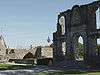
| Ruins of the castle of Rochefort (nl) (fr) |
Rochefort | 50°09′18″N 5°13′14″E / 50.154965°N 5.220613°E |
91114-CLT-0007-01 Info |
 | ||
| The towers, ramparts and walls of the ancient castle of Rochefort and the ensemble of the ruins of the old castle, the gardens around it, the walls and the castle with modern extensions (nl) (fr) |
Rochefort | 50°09′22″N 5°13′15″E / 50.156036°N 5.220841°E |
91114-CLT-0008-01 Info |
|||
| Ensemble of the marble quarry Saint-Remy (nl) (fr) |
Rochefort | 50°11′12″N 5°13′44″E / 50.186596°N 5.228869°E |
91114-CLT-0009-01 Info |
|||
| Plot of land to expand the site of the marble quarry Saint-Remy (nl) (fr) |
Rochefort | 50°11′13″N 5°13′41″E / 50.186998°N 5.228052°E |
91114-CLT-0010-01 Info |
|||
| Building: walls and roofs (nl) (fr) |
Rochefort | rue des Tanneries n° 6 | 50°09′42″N 5°13′12″E / 50.161774°N 5.219865°E |
91114-CLT-0011-01 Info |
||
| Facades, roofs and fences on the site for the house, and the ensemble of the house, fence, sidewalk and pavement of the road (nl) (fr) |
Rochefort | rue de Behogne n° 46, Rochefort | 50°09′40″N 5°13′22″E / 50.161168°N 5.222748°E |
91114-CLT-0012-01 Info |
||
| Square Francois Crepin (nl) (fr) |
Rochefort | 50°09′28″N 5°13′14″E / 50.157716°N 5.220429°E |
91114-CLT-0013-01 Info |
|||
| Ancient oak tree (nl) (fr) |
Rochefort | 50°08′39″N 5°12′55″E / 50.144172°N 5.215386°E |
91114-CLT-0014-01 Info |
|||
| Site called "Laide Fosse" <sup style="text-align:right; line-height:1em;
margin-left:0.3em; color:blue; cursor:help; font-family:Verdana,sans-serif;"
title="Site genaamd "Laide Fosse"">(nl) (fr) |
Rochefort | 50°08′22″N 5°12′09″E / 50.139315°N 5.202509°E |
91114-CLT-0015-01 Info |
|||
| House: walls, gable end roofs (nl) (fr) |
Rochefort | rue Jacquet n° 99 | 50°09′14″N 5°13′15″E / 50.153839°N 5.220830°E |
91114-CLT-0016-01 Info |
||
| Tower of the old city walls (nl) (fr) |
Rochefort | place Lafayette, achterzijde huis aan rue Jacquet n°99 | 50°09′13″N 5°13′16″E / 50.153748°N 5.221035°E |
91114-CLT-0017-01 Info |
||
| House: facade of the ground floor and first floor, except for the roofs (nl) (fr) |
Rochefort | rue Jacquet n° 77 | 50°09′16″N 5°13′17″E / 50.154520°N 5.221336°E |
91114-CLT-0019-01 Info |
||
| Ancient fortification "Tienne de la Roche" <sup style="text-align:right; line-height:1em;
margin-left:0.3em; color:blue; cursor:help; font-family:Verdana,sans-serif;"
title="Oude fortificatie van "Tienne de la Roche"">(nl) (fr) |
Rochefort | 50°08′20″N 5°10′32″E / 50.138952°N 5.175679°E |
91114-CLT-0020-01 Info |
|||
| Remains of a fort called "Vieux Château" <sup style="text-align:right; line-height:1em;
margin-left:0.3em; color:blue; cursor:help; font-family:Verdana,sans-serif;"
title="Overblijfselen van een fort genaamd "Vieux Château"">(nl) (fr) |
Rochefort | 50°09′21″N 5°14′22″E / 50.155788°N 5.239433°E |
91114-CLT-0021-01 Info |
|||
| Church of Saint-Michel and the wall of the cemetery and the ensemble of the building, the linden trees, the cemetery and the square (nl) (fr) |
Rochefort | 50°06′31″N 5°08′33″E / 50.108626°N 5.142469°E |
91114-CLT-0022-01 Info |
|||
| Chapel of Saint-Lambert and the ensemble of the chapel, the two lime trees and the surrounding area (nl) (fr) |
Rochefort | 50°06′45″N 5°10′03″E / 50.112427°N 5.167431°E |
91114-CLT-0023-01 Info |
|||
| Chapel of Saint-Remy (nl) (fr) |
Rochefort | 50°08′37″N 5°12′50″E / 50.143529°N 5.213763°E |
91114-CLT-0024-01 Info |
 | ||
| Chapel of Saint-Barthélemy (nl) (fr) |
Rochefort | 50°09′47″N 5°07′19″E / 50.162964°N 5.121902°E |
91114-CLT-0026-01 Info |
|||
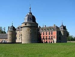
| Château de Lavaux-Sainte-Anne (nl) (fr) |
Rochefort | 50°06′58″N 5°05′30″E / 50.116043°N 5.091561°E |
91114-CLT-0027-01 Info |
 | ||
| Farm adjacent to castle of Lavaux-Sainte-Anne (nl) (fr) |
Rochefort | 50°06′57″N 5°05′31″E / 50.115763°N 5.091968°E |
91114-CLT-0028-01 Info |
|||
| Ensemble of the remains of the Roman Villa, called "Malagne" or "Chateau Neuf", and the outbuildings and the land of stones called, near the villa <sup style="text-align:right; line-height:1em;
margin-left:0.3em; color:blue; cursor:help; font-family:Verdana,sans-serif;"
title="Ensemble van de overblijfselen van de Romeinse Villa genaamd "de Malagne" of "Neufchâteau", en de bijgebouwen en het land van stenen genoemd, in de buurt van de villa">(nl) (fr) |
Rochefort | 50°09′41″N 5°14′20″E / 50.161301°N 5.239005°E |
91114-CLT-0029-01 Info |
|||
| Remains of the main building of the Gallo-Roman villa of Malagne (nl) (fr) |
Rochefort | 50°09′44″N 5°14′36″E / 50.162131°N 5.243330°E |
91114-CLT-0030-01 Info |
|||
| House: walls and roofs (nl) (fr) |
Rochefort | rue Jacquet n° 96 | 50°09′16″N 5°13′14″E / 50.154306°N 5.220646°E |
91114-CLT-0031-01 Info |
||
| Chapel of Genimont and its surroundings (nl) (fr) |
Rochefort | 50°07′16″N 5°06′44″E / 50.121065°N 5.112152°E |
91114-CLT-0032-01 Info |
|||
| Viewpoint of Forzée (nl) (fr) |
Rochefort | 50°13′43″N 5°10′45″E / 50.228713°N 5.179135°E |
91114-CLT-0033-01 Info |
|||
| Old mill Lessive: facades, roofs, machinery, parts of masonry, and the alluvial plain of the Lesse from the dam downstream (nl) (fr) |
Rochefort | 50°08′35″N 5°08′44″E / 50.143117°N 5.145660°E |
91114-CLT-0034-01 Info |
|||
| Farm Cavillot: facades and roofs, and the ensemble of the farm and surrounding area (nl) (fr) |
Rochefort | rue du Jardinia n° 13, Génimont | 50°07′11″N 5°06′39″E / 50.119758°N 5.110842°E |
91114-CLT-0035-01 Info |
||
| Chapel of Saint-Nicolas, called Reine Astrid, and the ensemble of the building and surrounding area (nl) (fr) |
Rochefort | 50°10′40″N 5°08′53″E / 50.177763°N 5.148070°E |
91114-CLT-0036-01 Info |
|||
| Cave "Le Trou Maulin" and a place called Beauregard <sup style="text-align:right; line-height:1em;
margin-left:0.3em; color:blue; cursor:help; font-family:Verdana,sans-serif;"
title="Grot "le Trou Maulin" en een plek genaamd Beauregard">(nl) (fr) |
Rochefort | 50°09′24″N 5°13′28″E / 50.156536°N 5.224480°E |
91114-CLT-0037-01 Info |
|||
| Pond of the village Wavreille (nl) (fr) |
Rochefort | 50°07′23″N 5°14′47″E / 50.123118°N 5.246333°E |
91114-CLT-0038-01 Info |
|||
| Expansion at the site of the pond in the village Wavreille (nl) (fr) |
Rochefort | 50°07′24″N 5°14′46″E / 50.123363°N 5.245978°E |
91114-CLT-0039-01 Info |
|||
| Avenue of chestnut trees for the output of the Han-sur-Lesse (nl) (fr) |
Rochefort | 50°07′20″N 5°11′21″E / 50.122233°N 5.189125°E |
91114-CLT-0040-01 Info |
|||
| Ensemble of l'Anticlinal and common areas of both sides of the Cluse Ry d'Ave (nl) (fr) |
Rochefort | Han-sur-Lesse | 50°07′03″N 5°10′25″E / 50.117419°N 5.173572°E |
91114-CLT-0041-01 Info |
||
| Site called "Belvedere" or "Rochers de Serin" <sup style="text-align:right; line-height:1em;
margin-left:0.3em; color:blue; cursor:help; font-family:Verdana,sans-serif;"
title="Site genaamd "Belvédère" of "Rochers de Serin"">(nl) (fr) |
Rochefort | 50°08′01″N 5°11′40″E / 50.133537°N 5.194555°E |
91114-CLT-0042-01 Info |
|||
| Stone bridge over the Wimbe, and the ensemble of the bridge near the castle and the farm (nl) (fr) |
Rochefort | 50°06′57″N 5°05′35″E / 50.115779°N 5.092966°E |
91114-CLT-0043-01 Info |
|||
| Facades and roofs (except synthetic part) of the 18th century farm located near the farm of the castle of Lavaux-Sainte-Anne, excluding the construction of the 19th century and a circumference of four land parcels forming a triangle, posterior of Wimbe and the other two sides of the streets and rue du Château le chemin de Neuville (nl) (fr) |
Rochefort | 50°06′55″N 5°05′35″E / 50.115380°N 5.092940°E |
91114-CLT-0044-01 Info |
|||
| Grassland or heathland "Tienne Moseray" <sup style="text-align:right; line-height:1em;
margin-left:0.3em; color:blue; cursor:help; font-family:Verdana,sans-serif;"
title="Graslanden of heidevelden van "Tienne Moseray"">(nl) (fr) |
Rochefort | 50°05′57″N 5°10′13″E / 50.099170°N 5.170209°E |
91114-CLT-0048-01 Info |
|||
| Château de Lavaux-Sainte-Anne (nl) (fr) |
Rochefort | 50°06′58″N 5°05′30″E / 50.116043°N 5.091561°E |
91114-PEX-0001-01 Info |
|||
| Ensemble of the common areas on both sides of the Cluse Ry d'Ave (nl) (fr) |
Rochefort | Han-sur-Lesse | 50°07′03″N 5°10′25″E / 50.117419°N 5.173572°E |
91114-PEX-0002-01 Info |
See also
| Wikimedia Commons has media related to Cultural heritage monuments in Rochefort, Belgium. |
References
- Belgian heritage register: Direction générale opérationnelle - Aménagement du territoire, Logement, Patrimoine et Energie (DG4)
- www.dglive.be