List of protected heritage sites in Profondeville
This table shows an overview of the protected heritage sites in the Walloon town Profondeville. This list is part of Belgium's national heritage.
| Object |
Year/architect |
Town/section |
Address |
Coordinates |
Number? |
Image |
|---|---|---|---|---|---|---|
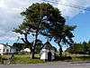
| Ensemble of the chapel of Saint-Roch, the two trees and the surrounding area (nl) (fr) |
Profondeville | 50°22′28″N 4°46′25″E / 50.374538°N 4.773557°E |
92101-CLT-0003-01 Info |
 | ||
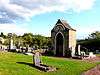
| Cemetery Chapel (nl) (fr) |
Profondeville | 50°22′24″N 4°46′48″E / 50.373215°N 4.779958°E |
92101-CLT-0004-01 Info |
 | ||
| Chantoir "Trou des Nutons" <sup style="text-align:right; line-height:1em;
margin-left:0.3em; color:blue; cursor:help; font-family:Verdana,sans-serif;"
title="Chantoir "Trou des Nutons"">(nl) (fr) |
Profondeville | 50°22′48″N 4°47′41″E / 50.380114°N 4.794745°E |
92101-CLT-0007-01 Info |
|||
| Chapel "au Loup" ensemble with its surroundings <sup style="text-align:right; line-height:1em;
margin-left:0.3em; color:blue; cursor:help; font-family:Verdana,sans-serif;"
title="Kapel "au Loup" en ensemble met diens omgeving">(nl) (fr) |
Profondeville | route de Saint-Gérard | 50°22′11″N 4°46′12″E / 50.369771°N 4.769915°E |
92101-CLT-0008-01 Info |
||
| Cave and re-welling of the Vilaine (nl) (fr) |
Profondeville | 50°22′25″N 4°49′18″E / 50.373535°N 4.821540°E |
92101-CLT-0009-01 Info |
|||
| Chantoir of Normont (nl) (fr) |
Profondeville | 50°22′15″N 4°48′15″E / 50.370806°N 4.804049°E |
92101-CLT-0010-01 Info |
|||
| Double Chantoir du Moulin (nl) (fr) |
Profondeville | 50°22′55″N 4°46′44″E / 50.381861°N 4.778985°E |
92101-CLT-0011-01 Info |
|||
| Chantoir of Trou du Renard (nl) (fr) |
Profondeville | 50°22′48″N 4°45′53″E / 50.379942°N 4.764788°E |
92101-CLT-0012-01 Info |
|||
| Cave of Trou d'Haquin (nl) (fr) |
Profondeville | 50°22′07″N 4°54′16″E / 50.368667°N 4.904320°E |
92101-CLT-0013-01 Info |
|||
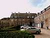
| castle Lesve (nl) (fr) |
Profondeville | 50°22′22″N 4°46′47″E / 50.372643°N 4.779721°E |
92101-CLT-0014-01 Info |
 | ||
| Surfacing from the 19th century towpath, between the river and Rouillon (nl) (fr) |
Profondeville | 50°21′12″N 4°52′33″E / 50.353360°N 4.875942°E |
92101-CLT-0015-01 Info |
|||
| Rochers de Frêne (nl) (fr) |
Profondeville | 50°22′49″N 4°52′12″E / 50.380319°N 4.870066°E |
92101-CLT-0016-01 Info |
See also
| Wikimedia Commons has media related to Cultural heritage monuments in Profondeville. |
References
- Belgian heritage register: Direction générale opérationnelle - Aménagement du territoire, Logement, Patrimoine et Energie (DG4)
- www.dglive.be
This article is issued from Wikipedia - version of the 8/4/2015. The text is available under the Creative Commons Attribution/Share Alike but additional terms may apply for the media files.