List of protected heritage sites in La Louvière
This table shows an overview of the protected heritage sites in the Walloon town La Louvière. This list is part of Belgium's national heritage.
| Object |
Year/architect |
Town/section |
Address |
Coordinates |
Number? |
Image |
|---|---|---|---|---|---|---|
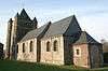
| Church of Saint-Vaast (nl) (fr) |
La Louvière | Saint-Vaast | 50°27′09″N 4°09′34″E / 50.452412°N 4.159580°E |
55022-CLT-0003-01 Info |
 | |
| Chapel Notre-Dame-au-Puits (nl) (fr) |
La Louvière | 50°27′05″N 4°08′49″E / 50.451302°N 4.146993°E |
55022-CLT-0004-01 Info |
.JPG) | ||
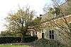
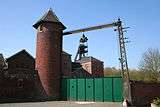
| Coal Mining and the oldest part of the town of Bois-du-Luc Houdeng Aimeries (nl) (fr) |
La Louvière | 50°28′28″N 4°08′45″E / 50.474372°N 4.145879°E |
55022-CLT-0005-01 Info |
 | ||
| Ensemble of the farm Sart-Longchamps called "Ferme Guyaux" and surrounding areas <sup style="text-align:right; line-height:1em;
margin-left:0.3em; color:blue; cursor:help; font-family:Verdana,sans-serif;"
title="Ensemble van de boerderij te Sart-Longchamps genaamd "Ferme Guyaux" en de omliggende terreinen">(nl) (fr) |
La Louvière | La Louvière | 50°28′34″N 4°12′12″E / 50.476210°N 4.203430°E |
55022-CLT-0006-01 Info |
||
| Expansion of the ensemble of the farm of Sart-Longchamps called "Ferme Guyaux" and surrounding areas <sup style="text-align:right; line-height:1em;
margin-left:0.3em; color:blue; cursor:help; font-family:Verdana,sans-serif;"
title="Uitbreiding van het ensemble van de boerderij van Sart-Longchamps genaamd "Ferme Guyaux" en de omliggende terreinen">(nl) (fr) |
La Louvière | La Louvière | 50°28′31″N 4°12′03″E / 50.475375°N 4.200859°E |
55022-CLT-0007-01 Info |
||
| The barn of the farm of Sart-Longchamps (nl) (fr) |
La Louvière | rue de Baume n°45, La Louvière | 50°28′36″N 4°12′02″E / 50.476628°N 4.200650°E |
55022-CLT-0008-01 Info |
||
| Facades and roofs of the house chaplain (nl) (fr) |
La Louvière | rue des Ecoles n°16, La Louvière | 50°27′35″N 4°05′16″E / 50.459649°N 4.087724°E |
55022-CLT-0010-01 Info |
||
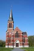
| Total chapel of Saint-Julien (nl) (fr) |
La Louvière | La Louvière | 50°27′34″N 4°05′16″E / 50.459579°N 4.087754°E |
55022-CLT-0011-01 Info |
.JPG) | |
| A dogwood and its surroundings (nl) (fr) |
La Louvière | La Louvière | 50°27′33″N 4°06′56″E / 50.459097°N 4.115564°E |
55022-CLT-0012-01 Info |
 | |
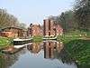
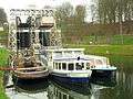
| Hydraulic lifts 1, 2, 3 and 4 located on the Canal du Centre and the bridge located between Nos. 3 and 4 (M) and the ensemble of these with the wooded shore banks (nl) (fr) |
La Louvière | 50°29′15″N 4°10′33″E / 50.487427°N 4.175825°E |
55022-CLT-0013-01 Info |
.JPG) | ||
| The facades and roofs of the building where the engine of lifts 2 and 3 are located (nl) (fr) |
La Louvière | 50°28′53″N 4°08′10″E / 50.481386°N 4.136043°E |
55022-CLT-0015-01 Info |
 | ||
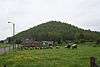
| Terril n ° 142 called "Albert 1er" <sup style="text-align:right; line-height:1em;
margin-left:0.3em; color:blue; cursor:help; font-family:Verdana,sans-serif;"
title="Terril n°142 genaamd "Albert 1er"">(nl) (fr) |
La Louvière | rue Léopold III à Saint-Vaast | 50°27′26″N 4°09′15″E / 50.457161°N 4.154084°E |
55022-CLT-0016-01 Info |
 | |
| Certain parts of the house (nl) (fr) |
La Louvière | rue Warocqué 70-72, La Louvière | 50°28′35″N 4°11′35″E / 50.476502°N 4.193109°E |
55022-CLT-0018-01 Info |
 | |
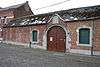
| Certain parts of the "Royal Boch": three bottle ovens and building the workshop and the southern bottle ovens houses <sup style="text-align:right; line-height:1em;
margin-left:0.3em; color:blue; cursor:help; font-family:Verdana,sans-serif;"
title="Bepaalde delen van de "Manufacture Royal Boch": drie flessen-ovens en het gebouw dat de werkplaats en de zuidelijke flessen-ovens huist">(nl) (fr) |
La Louvière | rue Sylvain Guyaux 70, La Louvière | 50°28′40″N 4°10′57″E / 50.477876°N 4.182560°E |
55022-CLT-0021-01 Info |
||
| Facades and roofs of the presbytery (nl) (fr) |
La Louvière | La Louvière | 50°27′14″N 4°12′03″E / 50.453778°N 4.200966°E |
55022-CLT-0022-01 Info |
 | |
| Totality of the old Hôpital Saint-Julien (nl) (fr) |
La Louvière | Boussoit | 50°27′34″N 4°05′16″E / 50.459332°N 4.087709°E |
55022-CLT-0025-01 Info |
.jpg) | |
| Coal Mining and the oldest part of the town of Bois-du-Luc Houdeng Aimeries (nl) (fr) |
La Louvière | 50°28′28″N 4°08′45″E / 50.474372°N 4.145879°E |
55022-PEX-0001-01 Info |
 | ||
| Hydraulic lifts 1, 2, 3 and 4 located on the Canal du Centre and the bridge located between Nos. 3 and 4 (M) and the ensemble of these with the wooded shore banks (nl) (fr) |
La Louvière | 50°29′15″N 4°10′33″E / 50.487427°N 4.175825°E |
55022-PEX-0002-01 Info |
 |
See also
| Wikimedia Commons has media related to Cultural heritage monuments in La Louvière. |
References
- Belgian heritage register: Direction générale opérationnelle - Aménagement du territoire, Logement, Patrimoine et Energie (DG4)
- www.dglive.be