List of protected heritage sites in Halen
This table shows an overview of the protected heritage sites in the Flemish town Halen. This list is part of Belgium's national heritage.
| Object |
Status? |
Year/architect |
Town/section |
Address |
Coordinates |
Number? |
Image |
|---|---|---|---|---|---|---|---|
| "Hoeve Vogel-sanck" farm <sup style="text-align:right; line-height:1em;
margin-left:0.3em; color:blue; cursor:help; font-family:Verdana,sans-serif;"
title=""Hoeve Vogel-sanck", hoeve">(nl) |
Halen | Betserbaan 72 | 50°57′15″N 5°05′34″E / 50.95409°N 5.09268°E | 21744 Info | |||
| farm (nl) |
Halen | Betserbaan 76 | 50°57′11″N 5°05′37″E / 50.95296°N 5.09369°E | 21745 Info | |||
| farm (nl) |
Halen | Ertsenrijkstraat 107 | 50°55′45″N 5°07′28″E / 50.92907°N 5.12451°E | 21748 Info | |||
| Closed farm 1852 (nl) |
|
Halen | Ertsenrijkstraat 115 | 50°55′32″N 5°07′27″E / 50.92547°N 5.12416°E | 21749 Info | ||
| lock (nl) |
Halen | Firmin Jacobslaan | 50°56′53″N 5°07′01″E / 50.94803°N 5.11688°E | 21750 Info | |||
| broad House (nl) |
Halen | Generaal de Wittestraat 3 | 50°56′54″N 5°06′48″E / 50.94830°N 5.11328°E | 21752 Info | |||
| double House (nl) |
Halen | Generaal de Wittestraat 5 | 50°56′54″N 5°06′47″E / 50.94838°N 5.11302°E | 21753 Info | |||
| double House (nl) |
|
Halen | Generaal de Wittestraat 10 | 50°56′53″N 5°06′45″E / 50.94799°N 5.11262°E | 21755 Info | ||
| double House (nl) |
|
Halen | Generaal de Wittestraat 12 | 50°56′53″N 5°06′45″E / 50.94799°N 5.11262°E | 21755 Info | ||
| double House (nl) |
Halen | Generaal de Wittestraat 14 | 50°56′53″N 5°06′45″E / 50.94799°N 5.11239°E | 21756 Info | |||
| double House (nl) |
Halen | Generaal de Wittestraat 21 | 50°56′54″N 5°06′44″E / 50.94831°N 5.11210°E | 21757 Info | |||
| double House (nl) |
Halen | Koepoortstraat 5 | 50°56′56″N 5°06′53″E / 50.94893°N 5.11479°E | 21760 Info | |||
| Iron Mining farm (nl) |
Halen | Ijzerwinningstraat 2 | 50°56′32″N 5°05′18″E / 50.94228°N 5.08834°E | 21761 Info | |||
| Parish St. Peter-in-Banden (nl) |
|
Halen | Markt | 50°56′55″N 5°06′53″E / 50.94862°N 5.11466°E | 21764 Info |  | |
| double House (nl) |
|
Halen | Markt 9 | 50°56′53″N 5°06′49″E / 50.94796°N 5.11357°E | 21765 Info | ||
| only House (nl) |
|
Halen | Markt 11 | 50°56′51″N 5°06′49″E / 50.94757°N 5.11367°E | 21766 Info | ||
| two homes (nl) |
Halen | Marktstraat 4 | 50°56′50″N 5°06′55″E / 50.94718°N 5.11520°E | 21771 Info | |||
| Farmer Burger House 1824 (nl) |
|
Halen | Nederstraat 1 | 50°56′53″N 5°06′55″E / 50.94812°N 5.11516°E | 21772 Info | ||
| two homes (nl) |
Halen | Staatsbaan 106 | 50°57′35″N 5°05′11″E / 50.95977°N 5.08641°E | 21774 Info | |||
| two homes (nl) |
Halen | Staatsbaan 108 | 50°57′35″N 5°05′11″E / 50.95977°N 5.08641°E | 21774 Info | |||
| broad House (nl) |
|
Halen | Zepbrugstraat 34 | 50°56′25″N 5°06′20″E / 50.94039°N 5.10543°E | 21778 Info | ||
| Jeneverdistillery, housing (nl) |
Halen | Zwarte Duivelsstraat 20 | 50°56′55″N 5°07′10″E / 50.94860°N 5.11933°E | 21779 Info | |||
| Watermill on the Gete, now home (nl) |
Halen | Zwarte Duivelsstraat 35 | 50°56′53″N 5°07′11″E / 50.94809°N 5.11959°E | 21781 Info |  | ||
| 1912 Chapel St. Donatus (nl) |
Halen | Lindestraat | 50°55′42″N 5°03′49″E / 50.92823°N 5.06356°E | 21782 Info | |||
| Blekkom Castle, 1859 <sup style="text-align:right; line-height:1em;
margin-left:0.3em; color:blue; cursor:help; font-family:Verdana,sans-serif;"
title=""Kasteel van Blekkom" herenhuis 1859">(nl) |
Halen | Lindestraat 124 | 50°55′23″N 5°04′32″E / 50.92314°N 5.07567°E | 21783 Info | 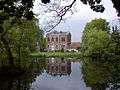 | ||
| St. Andrew Parish (nl) |
Halen | Loksbergenstraat | 50°56′05″N 5°04′14″E / 50.93484°N 5.07054°E | 21784 Info | 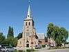 | ||
| Village house double house type (nl) |
Halen | Loksbergenstraat 43 | 50°56′02″N 5°04′05″E / 50.93380°N 5.06818°E | 21785 Info | |||
| Presbytery, classic double house (nl) |
Halen | Loksbergenstraat 25 | 50°56′06″N 5°04′15″E / 50.93498°N 5.07096°E | 21786 Info | |||
| village house (nl) |
Halen | Loksbergenstraat 54 | 50°55′59″N 5°04′06″E / 50.93318°N 5.06846°E | 21787 Info | |||
| Farmer Burger House, double house 1878 (nl) |
Halen | Loksbergenstraat 90 | 50°55′56″N 5°03′56″E / 50.93215°N 5.06568°E | 21789 Info | |||
| Semi-closed farm (nl) |
Halen | Oude Leuvensebaan 3 | 50°56′03″N 5°03′04″E / 50.93408°N 5.05119°E | 21790 Info | |||
| Vault Reynrode and chapel <sup style="text-align:right; line-height:1em;
margin-left:0.3em; color:blue; cursor:help; font-family:Verdana,sans-serif;"
title=""Kluis van Reynrode" en kapel">(nl) |
Halen | Oude Leuvensebaan 2 | 50°56′04″N 5°03′02″E / 50.93437°N 5.05059°E | 21791 Info | |||
| farm (nl) |
Halen | Oude Leuvensebaan 13 | 50°56′05″N 5°03′15″E / 50.93481°N 5.05430°E | 21792 Info | |||
| Rotemse mill <sup style="text-align:right; line-height:1em;
margin-left:0.3em; color:blue; cursor:help; font-family:Verdana,sans-serif;"
title=""Rotemse Molen", watermolen + molenhuis">(nl) |
|
Halen | Gidsenstraat 24 | 50°55′44″N 5°05′32″E / 50.92884°N 5.09219°E | 21794 Info | 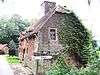 | |
| Abbey Mariendal, also called "Abbey Rothem" <sup style="text-align:right; line-height:1em;
margin-left:0.3em; color:blue; cursor:help; font-family:Verdana,sans-serif;"
title="Abdij Mariendal, ook "abdij van Rothem"">(nl) |
|
Halen | Rotemstraat 4 | 50°55′42″N 5°05′51″E / 50.92845°N 5.09759°E | 21795 Info | ||
| Farm standalone components (nl) |
|
Halen | Rotemstraat 14 | 50°55′38″N 5°05′34″E / 50.92721°N 5.09265°E | 21797 Info | ||
| St Pancras Parish Church (nl) |
Halen | Kerkstraat | 50°57′39″N 5°05′26″E / 50.96081°N 5.09049°E | 21798 Info | 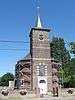 | ||
| Presbytery classical double house (nl) |
Halen | Kerkstraat 10 | 50°57′38″N 5°05′27″E / 50.96055°N 5.09095°E | 21799 Info | |||
| Zelker watermill <sup style="text-align:right; line-height:1em;
margin-left:0.3em; color:blue; cursor:help; font-family:Verdana,sans-serif;"
title=""Zelker-molen", watermolen">(nl) |
Halen | Zelemstraat 7 | 50°57′40″N 5°05′25″E / 50.96113°N 5.09015°E | 21801 Info | |||
| Parish Church Saint-Lambert (nl) |
|
Halen | Dorpsstraat 36 | 50°58′47″N 5°06′15″E / 50.97968°N 5.10423°E | 21803 Info | ||
| "Hoeve Eksterhoek" semi closed farm <sup style="text-align:right; line-height:1em;
margin-left:0.3em; color:blue; cursor:help; font-family:Verdana,sans-serif;"
title=""Hoeve Eksterhoek" semigesloten hoeve">(nl) |
Halen | Eksterhoekstraat 1 | 50°58′16″N 5°05′13″E / 50.97113°N 5.08687°E | 21804 Info | |||
| "Geesthuis" double-wide house <sup style="text-align:right; line-height:1em;
margin-left:0.3em; color:blue; cursor:help; font-family:Verdana,sans-serif;"
title=""Geesthuis" breedhuis dubbelhuis">(nl) |
|
Halen | Gennepstraat 22 | 50°59′02″N 5°05′03″E / 50.98375°N 5.08426°E | 21805 Info | ||
| Men's double house Property Type (nl) |
Halen | Kolenbergstraat 26 | 50°58′34″N 5°05′53″E / 50.97616°N 5.09817°E | 21809 Info | |||
| Loboshoeve castle farm <sup style="text-align:right; line-height:1em;
margin-left:0.3em; color:blue; cursor:help; font-family:Verdana,sans-serif;"
title=""Loboshoeve" kasteel met hoeve">(nl) |
Halen | Lobosstraat 2 | 50°59′00″N 5°06′29″E / 50.98333°N 5.10800°E | 21810 Info | |||
| farm (nl) |
Halen | Schomstraat | 50°58′21″N 5°05′42″E / 50.97249°N 5.09499°E | 21811 Info | |||
| Carthusian Monastery St. Jansdal (nl) |
|
Halen | Sint-Jansbergstraat 7-8-9 | 50°58′11″N 5°05′29″E / 50.96961°N 5.09143°E | 21812 Info |  | |
| Our Lady Chapel (nl) |
Halen | Steenbergstraat | 50°58′29″N 5°06′39″E / 50.97465°N 5.11085°E | 21813 Info | |||
| "Hoeve Oude Pastorij" U-shaped farm <sup style="text-align:right; line-height:1em;
margin-left:0.3em; color:blue; cursor:help; font-family:Verdana,sans-serif;"
title=""Hoeve Oude Pastorij", U-vormige hoeve">(nl) |
Halen | Steenbergstraat 20 | 50°58′22″N 5°05′56″E / 50.97276°N 5.09896°E | 21814 Info | |||
| "Hoeve Oude Pastorij" U-shaped farm <sup style="text-align:right; line-height:1em;
margin-left:0.3em; color:blue; cursor:help; font-family:Verdana,sans-serif;"
title=""Hoeve Oude Pastorij", U-vormige hoeve">(nl) |
Halen | Steenbergstraat 22 | 50°58′22″N 5°05′56″E / 50.97276°N 5.09896°E | 21814 Info | |||
| rectory (nl) |
Halen | Dorpsstraat 34 | 50°58′48″N 5°06′12″E / 50.97987°N 5.10325°E | 88629 Info |  | ||
| school section (nl) |
Halen | Dorpsstraat 39 | 50°58′45″N 5°06′16″E / 50.97905°N 5.10436°E | 88630 Info | |||
| Pan Factory "De Panoven" <sup style="text-align:right; line-height:1em;
margin-left:0.3em; color:blue; cursor:help; font-family:Verdana,sans-serif;"
title="Pannenfabriek "De Panoven"">(nl) |
|
Halen | Panovenstraat 45 | 50°55′52″N 5°04′16″E / 50.93124°N 5.07110°E | 200349 Info | ||
| Belgian military cemetery (nl) |
|
Halen | Liniestraat | 50°56′13″N 5°05′57″E / 50.93702°N 5.09905°E | 200660 Info | 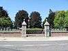 |
See also
| Wikimedia Commons has media related to Onroerend erfgoed in Halen. |