List of protected heritage sites in Enghien
This table shows an overview of the protected heritage sites in the Walloon town Enghien. This list is part of Belgium's national heritage.
| Object |
Year/architect |
Town/section |
Address |
Coordinates |
Number? |
Image |
|---|---|---|---|---|---|---|
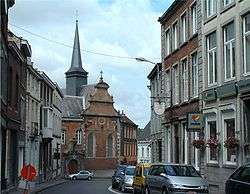
| Church of Saint Nicolas (nl) (fr) |
Edingen | 50°41′35″N 4°02′21″E / 50.693119°N 4.039163°E |
55010-CLT-0002-01 Info |
.jpg) | ||
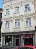
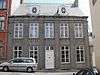
| Jonathas house (nl) (fr) |
Edingen | rue d'Hoves, n° 7 | 50°41′36″N 4°02′17″E / 50.693298°N 4.038159°E |
55010-CLT-0003-01 Info |
.JPG) | |
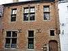
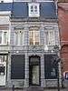
| House Algoet or Renard: facade (nl) (fr) |
Edingen | rue de Bruxelles, n° 15 | 50°41′37″N 4°02′24″E / 50.693711°N 4.040067°E |
55010-CLT-0004-01 Info |
 | |
| Building "Entrée du château ': main facade <sup style="text-align:right; line-height:1em;
margin-left:0.3em; color:blue; cursor:help; font-family:Verdana,sans-serif;"
title="Gebouw "Entrée du château": hoofdgevel">(nl) (fr) |
Edingen | rue du Château | 50°41′31″N 4°02′22″E / 50.691915°N 4.039367°E |
55010-CLT-0005-01 Info |
 | |
| Bridge "Pont de la Dodane" and surrounding areas <sup style="text-align:right; line-height:1em;
margin-left:0.3em; color:blue; cursor:help; font-family:Verdana,sans-serif;"
title="Brug "Pont de la Dodane" en de omliggende terreinen">(nl) (fr) |
Edingen | rue d'Hoves | 50°41′35″N 4°01′53″E / 50.693001°N 4.031421°E |
55010-CLT-0006-01 Info |
||
| The old buildings at the entrance to the field of Castle of Enghien, including the former stables, pavilion Edouard, the door, the chapel and the pavilion called "Pavillon des Sept Etoiles" and the ensemble of castle, outbuildings and adjacent areas <sup style="text-align:right; line-height:1em;
margin-left:0.3em; color:blue; cursor:help; font-family:Verdana,sans-serif;"
title="De oude gebouwen aan de ingang van het terrein van het kasteel van Enghien, met inbegrip van de voormalige stallen, het paviljoen Edouard, de deur, de kapel en het paviljoen genaamd "Pavillon des Sept Etoiles" en het ensemble van het kasteel, de bijgebouwen en de aangrenzende terreinen">(nl) (fr) |
Edingen | 50°41′32″N 4°02′27″E / 50.692184°N 4.040844°E |
55010-CLT-0008-01 Info |
.JPG) | ||
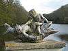
| Chinese pavilion in the park of castle Arenberg (nl) (fr) |
Edingen | 50°41′24″N 4°02′27″E / 50.689941°N 4.040854°E |
55010-CLT-0009-01 Info |
|||
| Arenberg Castle Park (nl) (fr) |
Edingen | 50°41′26″N 4°02′31″E / 50.690665°N 4.041935°E |
55010-CLT-0011-01 Info |
 | ||
| House called "du Paradis" <sup style="text-align:right; line-height:1em;
margin-left:0.3em; color:blue; cursor:help; font-family:Verdana,sans-serif;"
title="Huis genoemd "du Paradis"">(nl) (fr) |
Edingen | rue du Château n° 25 | 50°41′30″N 4°02′21″E / 50.691623°N 4.039141°E |
55010-CLT-0013-01 Info |
 | |
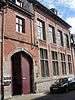
| Augustinian monastery: chapel (and his furniture), convent (ground floor), wing in the corner of rue de la fontaine Augustins and walls and roof side garden to street frontage, facade on rue du bâtiment ancien (nl) (fr) |
Edingen | rue des Augustins | 50°41′32″N 4°02′15″E / 50.692230°N 4.037374°E |
55010-CLT-0014-01 Info |
 | |
| Convent of the Colettine Poor Clares: chapel (wall), portal, square tower and tower (nl) (fr) |
Edingen | rue des Augustins n° 2 | 50°41′35″N 4°02′13″E / 50.692978°N 4.036881°E |
55010-CLT-0015-01 Info |
 | |
| Municipal park with ice-cellar and "motte of Brabant", between the streets Albert Ier and Elisabeth <sup style="text-align:right; line-height:1em;
margin-left:0.3em; color:blue; cursor:help; font-family:Verdana,sans-serif;"
title="sectionlijk park met ijskelder en de "motte de Brabant", tussen de straten avenues Albert Ier en Elisabeth">(nl) (fr) |
Edingen | 50°41′35″N 4°02′27″E / 50.693136°N 4.040890°E |
55010-CLT-0016-01 Info |
|||
| House of old convent: facades and roofs (nl) (fr) |
Edingen | rue du Béguinage n°10 | 50°41′29″N 4°02′09″E / 50.691260°N 4.035922°E |
55010-CLT-0017-01 Info |
||
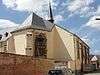
| St. Martin's Church (nl) (fr) |
Marcq Edingen | 50°41′32″N 4°01′04″E / 50.692321°N 4.017807°E |
55010-CLT-0018-01 Info |
_JPG00b.jpg) | ||
| Windmill and forest called "Moulin de Coqjan" <sup style="text-align:right; line-height:1em;
margin-left:0.3em; color:blue; cursor:help; font-family:Verdana,sans-serif;"
title="Windmolen en bos genaamd "Moulin de Coqjan"">(nl) (fr) |
Edingen | 50°41′52″N 4°04′48″E / 50.697655°N 4.080073°E |
55010-CLT-0019-01 Info |
|||
| Old fortifications of the avenue between street Albert Ier and Street Bruxelles (nl) (fr) |
Edingen | 50°41′39″N 4°02′29″E / 50.694176°N 4.041500°E |
55010-CLT-0020-01 Info |
|||
| House: walls and roofs (nl) (fr) |
Edingen | rue d'Hérinnes n° 12 | 50°41′38″N 4°02′21″E / 50.693800°N 4.039173°E |
55010-CLT-0021-01 Info |
 | |
| House: walls and roofs (nl) (fr) |
Edingen | rue de la Fontaine n° 22 | 50°41′31″N 4°02′17″E / 50.692016°N 4.038018°E |
55010-CLT-0022-01 Info |
 | |
| Watermill and environment (nl) (fr) |
Edingen | chaussée d'Ath | 50°41′11″N 4°00′42″E / 50.686350°N 4.011569°E |
55010-CLT-0023-01 Info |
||
| House called "Le Gouvernement": main building: walls, roof, upholstery and stairs, two extensions: facades and roof, baroque ceiling <sup style="text-align:right; line-height:1em;
margin-left:0.3em; color:blue; cursor:help; font-family:Verdana,sans-serif;"
title="Huis genaamd "Le Gouvernement": hoofdgebouw: gevels, dak, bekleding en trap, twee aanbouwen: gevels en dak, barok plafond">(nl) (fr) |
Edingen | rue du Château n° 6 | 50°41′33″N 4°02′24″E / 50.692570°N 4.039899°E |
55010-CLT-0024-01 Info |
 | |
| House of old convent: facades and roofs (nl) (fr) |
Edingen | rue du Béguinage n°12 | 50°41′31″N 4°02′08″E / 50.691893°N 4.035515°E |
55010-CLT-0025-01 Info |
||
| House of old convent: facades and roofs (nl) (fr) |
Edingen | rue du Béguinage n°14 | 50°41′31″N 4°02′08″E / 50.691871°N 4.035535°E |
55010-CLT-0026-01 Info |
||
| House of old convent: facades and roofs (nl) (fr) |
Edingen | rue du Béguinage n°16 | 50°41′31″N 4°02′08″E / 50.691843°N 4.035558°E |
55010-CLT-0027-01 Info |
 | |
| House of old convent: facades and roofs (nl) (fr) |
Edingen | rue du Béguinage n°18 | 50°41′31″N 4°02′08″E / 50.691819°N 4.035576°E |
55010-CLT-0028-01 Info |
||
| House of old convent: facades and roofs (nl) (fr) |
Edingen | rue du Béguinage n°26 | 50°41′29″N 4°02′09″E / 50.691267°N 4.035896°E |
55010-CLT-0029-01 Info |
.jpg) | |
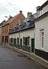
| House of old convent: facades and roofs (nl) (fr) |
Edingen | rue du Béguinage n°28 | 50°41′28″N 4°02′09″E / 50.691246°N 4.035906°E |
55010-CLT-0030-01 Info |
| |
| House of old convent: facades and roofs (nl) (fr) |
Edingen | rue du Béguinage n°30 | 50°41′28″N 4°02′09″E / 50.691217°N 4.035924°E |
55010-CLT-0031-01 Info |
| |
| House of old convent: facades and roofs (nl) (fr) |
Edingen | rue du Béguinage n°32 | 50°41′28″N 4°02′09″E / 50.691197°N 4.035942°E |
55010-CLT-0032-01 Info |
| |
| House of old convent: facades and roofs (nl) (fr) |
Edingen | rue du Béguinage n°34 | 50°41′28″N 4°02′09″E / 50.691172°N 4.035964°E |
55010-CLT-0033-01 Info |
| |
| House of old convent: facades and roofs (nl) (fr) |
Edingen | rue du Béguinage n°36 | 50°41′28″N 4°02′10″E / 50.691145°N 4.035976°E |
55010-CLT-0034-01 Info |
| |
| House of old convent: facades and roofs (nl) (fr) |
Edingen | rue du Béguinage n°38 | 50°41′28″N 4°02′10″E / 50.691118°N 4.036002°E |
55010-CLT-0035-01 Info |
.jpg) | |
| House of old convent: facades and roofs (nl) (fr) |
Edingen | rue du Béguinage n°40 | 50°41′28″N 4°02′10″E / 50.691089°N 4.036012°E |
55010-CLT-0036-01 Info |
| |
| The pavilion of Sept Etoiles and the park of Castle Arenberg, limited to the portion of the park, except the golf course (nl) (fr) |
Edingen | 50°41′16″N 4°02′50″E / 50.687656°N 4.047325°E |
55010-PEX-0001-01 Info |
.jpg) | ||
| Chinese pavilion in the park of castle Arenberg (nl) (fr) |
Edingen | 50°41′24″N 4°02′27″E / 50.689941°N 4.040854°E |
55010-PEX-0002-01 Info |
|||
| The buffet and organ of the church Saint-Martin (nl) (fr) |
Edingen | 50°41′32″N 4°01′04″E / 50.692321°N 4.017807°E |
55010-PEX-0003-01 Info |
See also
| Wikimedia Commons has media related to Cultural heritage monuments in Enghien. |
References
- Belgian heritage register: Direction générale opérationnelle - Aménagement du territoire, Logement, Patrimoine et Energie (DG4)
- www.dglive.be