List of protected heritage sites in Chastre
This table shows an overview of the protected heritage sites in the Walloon town Chastre. This list is part of Belgium's national heritage.
| Object |
Year/architect |
Town/section |
Address |
Coordinates |
Number? |
Image |
|---|---|---|---|---|---|---|
| Farm located at Rue de la Station # 43 (M) and its surroundings (S) (nl) (fr) |
Chastre | Rue de la Station nr. 43 | 50°36′39″N 4°38′39″E / 50.610834°N 4.644301°E |
25117-CLT-0001-01 Info |
.jpg) | |
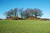
| Tumuli of Noirmont, two graves and their surroundings (nl) (fr) |
Chastre | 50°36′08″N 4°38′35″E / 50.602089°N 4.643188°E |
25117-CLT-0002-01 Info |
 | ||
| The facades and the entire roof of the farmhouse "La Grande Bierwart" located at No. 32 <sup style="text-align:right; line-height:1em;
margin-left:0.3em; color:blue; cursor:help; font-family:Verdana,sans-serif;"
title="De gevels en het hele dak van de boerderij "La Grande Bierwart" gelegen aan nr. 32">(nl) (fr) |
Chastre | rue de Mellery | 50°35′02″N 4°36′03″E / 50.583834°N 4.600926°E |
25117-CLT-0003-01 Info |
||
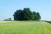
| The archaeological site tumuli of Noirmont in "Champ des Tombes" <sup style="text-align:right; line-height:1em;
margin-left:0.3em; color:blue; cursor:help; font-family:Verdana,sans-serif;"
title="De archeologische site Tumuli van Noirmont op het gebied "Champ des Tombes"">(nl) (fr) |
Chastre | 50°36′04″N 4°38′22″E / 50.601170°N 4.639492°E |
25117-PEX-0001-01 Info |
 |
See also
| Wikimedia Commons has media related to Cultural heritage monuments in Chastre. |
References
- Belgian heritage register: Direction générale opérationnelle - Aménagement du territoire, Logement, Patrimoine et Energie (DG4)
- www.dglive.be
This article is issued from Wikipedia - version of the 9/24/2016. The text is available under the Creative Commons Attribution/Share Alike but additional terms may apply for the media files.