List of protected heritage sites in Bree, Belgium
This table shows an overview of the protected heritage sites in the Flemish town Bree, Belgium. This list is part of Belgium's national heritage.
| Object |
Status? |
Year/architect |
Town/section |
Address |
Coordinates |
Number? |
Image |
|---|---|---|---|---|---|---|---|
| Chapel of the Three Sisters (nl) (fr) |
Bree | Abroxweg | 51°09′23″N 5°36′08″E / 51.15652°N 5.60232°E | 70778 Info | |||
| Abroxmolen <sup style="text-align:right; line-height:1em;
margin-left:0.3em; color:blue; cursor:help; font-family:Verdana,sans-serif;"
title=""Abroxmolen"">(nl) |
Bree | Abroxweg 41 | 51°09′58″N 5°35′54″E / 51.16600°N 5.59838°E | 70779 Info | |||
| Farm (nl) (fr) |
Bree | Abroxweg 48 | 51°09′57″N 5°36′00″E / 51.16570°N 5.59990°E | 70780 Info | |||
| U-shaped farm (nl) (fr) |
Bree | Abroxweg 51 | 51°10′04″N 5°36′08″E / 51.16783°N 5.60215°E | 70781 Info | |||
| Farmstead "Emeshof" <sup style="text-align:right; line-height:1em;
margin-left:0.3em; color:blue; cursor:help; font-family:Verdana,sans-serif;"
title="Hoeve "Emeshof"">(nl) <sup style="text-align:right; line-height:1em; margin-left:0.3em; color:blue; cursor:help; font-family:Verdana,sans-serif;"
title="Ferme "Emeshof"">(fr) |
Bree | Genattestraat 31 | 51°09′37″N 5°35′16″E / 51.16038°N 5.58770°E | 70782 Info | |||
| Genamolen <sup style="text-align:right; line-height:1em;
margin-left:0.3em; color:blue; cursor:help; font-family:Verdana,sans-serif;"
title=""Genamolen"">(nl) |
|
Bree | Genattestraat 39 | 51°09′46″N 5°35′24″E / 51.16281°N 5.58992°E | 70783 Info | ||
| elongated farm of 1860 (nl) (fr) |
Bree | Jef van Hoofstraat 9 | 51°09′17″N 5°36′20″E / 51.15479°N 5.60554°E | 70784 Info | |||
| Our Lady Chapel (nl) (fr) |
Bree | Kapelstraat | 51°09′37″N 5°35′47″E / 51.16038°N 5.59630°E | 70785 Info | |||
| St. Martin Parish (nl) (fr) |
|
Bree | Kerkstraat | 51°09′18″N 5°36′11″E / 51.15502°N 5.60313°E | 70786 Info | ||
| Chapel of Our Lady of Peace (nl) (fr) |
Bree | Kerkstraat | 51°09′41″N 5°36′29″E / 51.16131°N 5.60812°E | 70787 Info | |||
| Farm (nl) (fr) |
Bree | Kerkstraat 1 | 51°09′15″N 5°36′07″E / 51.15410°N 5.60202°E | 70788 Info | |||
| Farm (nl) (fr) |
Bree | Kerkstraat 3 | 51°09′15″N 5°36′07″E / 51.15410°N 5.60202°E | 70788 Info | |||
| Former presbytery (nl) (fr) |
Bree | Kerkstraat 6 | 51°09′16″N 5°36′12″E / 51.15456°N 5.60321°E | 70789 Info | |||
| Bipartisan farm of 1842 (nl) (fr) |
Bree | Kerkstraat 31 | 51°09′25″N 5°36′14″E / 51.15695°N 5.60382°E | 70790 Info | |||
| Farmstead "Mariahof" <sup style="text-align:right; line-height:1em;
margin-left:0.3em; color:blue; cursor:help; font-family:Verdana,sans-serif;"
title="Hoeve "Mariahof"">(nl) <sup style="text-align:right; line-height:1em; margin-left:0.3em; color:blue; cursor:help; font-family:Verdana,sans-serif;"
title="Ferme "Mariahof"">(fr) |
Bree | Mariahofstraat 51 | 51°10′40″N 5°39′48″E / 51.17787°N 5.66343°E | 70791 Info | |||
| Former watermill, Schoot (nl) (fr) |
Bree | Schootstraat 64 | 51°09′35″N 5°34′56″E / 51.15975°N 5.58211°E | 70792 Info | |||
| Farmstead "Kroezenhof" <sup style="text-align:right; line-height:1em;
margin-left:0.3em; color:blue; cursor:help; font-family:Verdana,sans-serif;"
title="Hoeve "Kroezenhof"">(nl) <sup style="text-align:right; line-height:1em; margin-left:0.3em; color:blue; cursor:help; font-family:Verdana,sans-serif;"
title="Ferme "Kroezenhof"">(fr) |
Bree | Vennestraat 30 | 51°09′31″N 5°35′02″E / 51.15863°N 5.58387°E | 70793 Info | |||
| Farmstead "Kroezenhof" <sup style="text-align:right; line-height:1em;
margin-left:0.3em; color:blue; cursor:help; font-family:Verdana,sans-serif;"
title="Hoeve "Kroezenhof"">(nl) <sup style="text-align:right; line-height:1em; margin-left:0.3em; color:blue; cursor:help; font-family:Verdana,sans-serif;"
title="Ferme "Kroezenhof"">(fr) |
Bree | Vennestraat 32 | 51°09′31″N 5°35′02″E / 51.15863°N 5.58387°E | 70793 Info | |||
| Farmstead "Kupkenshof" <sup style="text-align:right; line-height:1em;
margin-left:0.3em; color:blue; cursor:help; font-family:Verdana,sans-serif;"
title="Hoeve "Kupkenshof"">(nl) <sup style="text-align:right; line-height:1em; margin-left:0.3em; color:blue; cursor:help; font-family:Verdana,sans-serif;"
title="Ferme "Kupkenshof"">(fr) |
Bree | Waterstraat 8 | 51°10′10″N 5°36′19″E / 51.16956°N 5.60514°E | 70794 Info | |||
| Two house farm (nl) (fr) |
Bree | Waterstraat 9 | 51°10′06″N 5°36′49″E / 51.16824°N 5.61364°E | 70795 Info | |||
| Small house (nl) (fr) |
Bree | Witte Torenwal 21 | 51°08′33″N 5°35′51″E / 51.14248°N 5.59756°E | 70796 Info | |||
| Small house (nl) (fr) |
Bree | Bocholterkiezel 5 | 51°08′40″N 5°35′37″E / 51.14432°N 5.59374°E | 70797 Info | |||
| Detached house from the early XX (nl) (fr) |
Bree | Bocholterkiezel 6 | 51°08′40″N 5°35′40″E / 51.14456°N 5.59439°E | 70798 Info | |||
| Part of a former dual farm (nl) (fr) |
Bree | Bocholterkiezel 13 | 51°08′43″N 5°35′37″E / 51.14526°N 5.59374°E | 70799 Info | |||
| Farmstead "Mussenburghof" <sup style="text-align:right; line-height:1em;
margin-left:0.3em; color:blue; cursor:help; font-family:Verdana,sans-serif;"
title="Hoeve "Mussenburghof"">(nl) <sup style="text-align:right; line-height:1em; margin-left:0.3em; color:blue; cursor:help; font-family:Verdana,sans-serif;"
title="Ferme "Mussenburghof"">(fr) |
Bree | Brugstraat 76 | 51°08′31″N 5°37′06″E / 51.14198°N 5.61831°E | 70800 Info | |||
| Farmstead "Swennenhof" <sup style="text-align:right; line-height:1em;
margin-left:0.3em; color:blue; cursor:help; font-family:Verdana,sans-serif;"
title="Hoeve "Swennenhof"">(nl) <sup style="text-align:right; line-height:1em; margin-left:0.3em; color:blue; cursor:help; font-family:Verdana,sans-serif;"
title="Ferme "Swennenhof"">(fr) |
Bree | Driehoevenstraat 21 | 51°08′57″N 5°36′12″E / 51.14917°N 5.60334°E | 70801 Info | |||
| Corner house in eclectic style (nl) (fr) |
Bree | Gerdingerpoort 1 | 51°08′32″N 5°35′42″E / 51.14232°N 5.59487°E | 70803 Info | |||
| Former company P. Bergmans-Valle Houthandel (nl) (fr) |
Bree | Gerdingerpoort 5 | 51°08′33″N 5°35′41″E / 51.14261°N 5.59459°E | 70804 Info | |||
| house (nl) |
Bree | Gerdingerpoort 7 | 51°08′35″N 5°35′37″E / 51.14294°N 5.59373°E | 70805 Info | |||
| Mansion (nl) |
Bree | Gerdingerpoort 10 | 51°08′34″N 5°35′41″E / 51.14281°N 5.59486°E | 70806 Info | |||
| House "De Sterre" <sup style="text-align:right; line-height:1em;
margin-left:0.3em; color:blue; cursor:help; font-family:Verdana,sans-serif;"
title="Huis "De Sterre"">(nl) |
Bree | Gerdingerstraat 1 | 51°08′29″N 5°35′45″E / 51.14142°N 5.59587°E | 70807 Info | |||
| House "Die Swaene" <sup style="text-align:right; line-height:1em;
margin-left:0.3em; color:blue; cursor:help; font-family:Verdana,sans-serif;"
title="Huis "Die Swaene"">(nl) |
Bree | Gerdingerstraat 5 | 51°08′30″N 5°35′45″E / 51.14154°N 5.59579°E | 70808 Info | |||
| House "Die Swaene" <sup style="text-align:right; line-height:1em;
margin-left:0.3em; color:blue; cursor:help; font-family:Verdana,sans-serif;"
title="Huis "Die Swaene"">(nl) <sup style="text-align:right; line-height:1em; margin-left:0.3em; color:blue; cursor:help; font-family:Verdana,sans-serif;"
title="Maison "Die Swaene"">(fr) |
Bree | Gerdingerstraat 7 | 51°08′30″N 5°35′45″E / 51.14154°N 5.59579°E | 70808 Info | |||
| house with baroque views (nl) (fr) |
Bree | Gerdingerstraat 8 | 51°08′31″N 5°35′45″E / 51.14184°N 5.59585°E | 70809 Info | |||
| Broad house (nl) (fr) |
Bree | Gerdingerstraat 10 | 51°08′31″N 5°35′45″E / 51.14195°N 5.59589°E | 70810 Info | |||
| house (nl) (fr) |
Bree | Gerdingerstraat 11 | 51°08′30″N 5°35′44″E / 51.14168°N 5.59565°E | 70811 Info | |||
| Two large houses with identical façade decoration (nl) (fr) |
Bree | Gerdingerstraat 13 | 51°08′30″N 5°35′44″E / 51.14178°N 5.59547°E | 70812 Info | |||
| Two large houses with identical façade decoration (nl) (fr) |
Bree | Gerdingerstraat 15 | 51°08′30″N 5°35′44″E / 51.14178°N 5.59547°E | 70812 Info | |||
| house (nl) (fr) |
Bree | Gerdingerstraat 17 | 51°08′31″N 5°35′44″E / 51.14182°N 5.59542°E | 70813 Info | |||
| house (nl) (fr) |
Bree | Gerdingerstraat 19 | 51°08′31″N 5°35′43″E / 51.14184°N 5.59525°E | 70814 Info | |||
| Broad House late XIX-early XX (nl) (fr) |
Bree | Gerdingerstraat 21 | 51°08′31″N 5°35′43″E / 51.14190°N 5.59522°E | 70815 Info | |||
| house (nl) (fr) |
Bree | Gerdingerstraat 23 | 51°08′31″N 5°35′43″E / 51.14197°N 5.59521°E | 70816 Info | |||
| Primary school (nl) (fr) |
Bree | Grauwe Torenwal 16 | 51°08′21″N 5°35′59″E / 51.13921°N 5.59968°E | 70817 Info | |||
| detached house of XIXc (nl) (fr) |
Bree | Gruitroderkiezel 6 | 51°08′14″N 5°35′37″E / 51.13734°N 5.59367°E | 70818 Info | |||
| Detached villa (nl) (fr) |
Bree | Gruitroderkiezel 46 | 51°08′02″N 5°35′34″E / 51.13402°N 5.59265°E | 70819 Info | |||
| Castle "De Viggel" <sup style="text-align:right; line-height:1em;
margin-left:0.3em; color:blue; cursor:help; font-family:Verdana,sans-serif;"
title="Kasteel "De Viggel"">(nl) |
Bree | Gruitroderkiezel 73 | 51°07′55″N 5°35′52″E / 51.13187°N 5.59782°E | 70820 Info | |||
| Church of Our Lady of the Sacred Heart (nl) (fr) |
Bree | Gruitroderkiezel 206 | 51°07′20″N 5°35′29″E / 51.12224°N 5.59140°E | 70821 Info | |||
| St. Michael Parish (nl) (fr) |
|
Bree | Hoogstraat | 51°08′28″N 5°35′52″E / 51.14117°N 5.59776°E | 70822 Info | 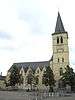 | |
| Former inn "In de Croen" <sup style="text-align:right; line-height:1em;
margin-left:0.3em; color:blue; cursor:help; font-family:Verdana,sans-serif;"
title="Voormalige herberg "In de Croen"">(nl) <sup style="text-align:right; line-height:1em; margin-left:0.3em; color:blue; cursor:help; font-family:Verdana,sans-serif;"
title="Ancien relais "In de Croen"">(fr) |
Bree | Hoogstraat 2 | 51°08′26″N 5°35′53″E / 51.14067°N 5.59804°E | 70823 Info | |||
| House early XX (nl) (fr) |
Bree | Hoogstraat 4 | 51°08′27″N 5°35′53″E / 51.14075°N 5.59815°E | 70824 Info | |||
| House early XX (nl) (fr) |
Bree | Hoogstraat 6 | 51°08′27″N 5°35′53″E / 51.14075°N 5.59815°E | 70824 Info | |||
| house in eclectic style (nl) (fr) |
Bree | Hoogstraat 5 | 51°08′29″N 5°35′55″E / 51.14144°N 5.59862°E | 70827 Info | |||
| House "De Rode Leeuw" (nl) |
Bree | Hoogstraat 8 | 51°08′27″N 5°35′54″E / 51.14079°N 5.59824°E | 70828 Info | |||
| House "De Rode Leeuw" (nl) |
Bree | Hoogstraat 10 | 51°08′27″N 5°35′54″E / 51.14079°N 5.59824°E | 70828 Info | |||
| house (nl) (fr) |
Bree | Hoogstraat 12 | 51°08′27″N 5°35′54″E / 51.14090°N 5.59839°E | 70829 Info | |||
| house (nl) (fr) |
Bree | Hoogstraat 13 | 51°08′30″N 5°35′57″E / 51.14165°N 5.59908°E | 70830 Info | |||
| House "Princenhof" <sup style="text-align:right; line-height:1em;
margin-left:0.3em; color:blue; cursor:help; font-family:Verdana,sans-serif;"
title="Huis "Prinsenhof"">(nl) |
Bree | Hoogstraat 20 | 51°08′27″N 5°35′56″E / 51.14080°N 5.59887°E | 70831 Info | |||
| Two large houses (nl) (fr) |
Bree | Hoogstraat 22 | 51°08′27″N 5°35′56″E / 51.14080°N 5.59887°E | 70832 Info | |||
| house (nl) (fr) |
Bree | Hoogstraat 32 | 51°08′30″N 5°35′58″E / 51.14153°N 5.59957°E | 70833 Info | |||
| Farmstead "Philpkenshof" <sup style="text-align:right; line-height:1em;
margin-left:0.3em; color:blue; cursor:help; font-family:Verdana,sans-serif;"
title="Hoeve "Philpkenshof"">(nl) |
Bree | Houterstraat 21 | 51°09′09″N 5°38′25″E / 51.15260°N 5.64029°E | 70834 Info | |||
| "Kaaihoeve" <sup style="text-align:right; line-height:1em;
margin-left:0.3em; color:blue; cursor:help; font-family:Verdana,sans-serif;"
title=""Kaaihoeve"">(nl) |
Bree | Kanaalkaai 1 | 51°08′40″N 5°36′57″E / 51.14439°N 5.61573°E | 70835 Info | |||
| Former office (nl) (fr) |
Bree | Kanaalkaai 5 | 51°08′38″N 5°37′00″E / 51.14388°N 5.61679°E | 70836 Info | |||
| house (nl) (fr) |
Bree | Kanaalkom 4 | 51°08′49″N 5°36′42″E / 51.14703°N 5.61174°E | 70837 Info | |||
| house (nl) (fr) |
Bree | Kanaallaan 1 | 51°08′36″N 5°36′15″E / 51.14341°N 5.60404°E | 70838 Info | |||
| house (nl) (fr) |
Bree | Kanaallaan 3 | 51°08′37″N 5°36′15″E / 51.14373°N 5.60404°E | 70839 Info | |||
| Terraced houses from the '30s (nl) (fr) |
Bree | Kanaallaan 19 | 51°08′39″N 5°36′21″E / 51.14418°N 5.60577°E | 70840 Info | |||
| Terraced houses from the '30s (nl) (fr) |
Bree | Kanaallaan 21 | 51°08′39″N 5°36′21″E / 51.14418°N 5.60577°E | 70840 Info | |||
| Terraced houses from the '30s (nl) (fr) |
Bree | Kanaallaan 23 | 51°08′39″N 5°36′21″E / 51.14418°N 5.60577°E | 70840 Info | |||
| house (nl) (fr) |
Bree | Kanaallaan 20 | 51°08′38″N 5°36′23″E / 51.14379°N 5.60627°E | 70841 Info | |||
| house (nl) (fr) |
Bree | Kanaallaan 25 | 51°08′40″N 5°36′21″E / 51.14432°N 5.60579°E | 70842 Info | |||
| house (nl) (fr) |
Bree | Kanaallaan 25A | 51°08′40″N 5°36′21″E / 51.14432°N 5.60579°E | 70842 Info | |||
| Villa (nl) (fr) |
Bree | Kanaallaan 27 | 51°08′40″N 5°36′23″E / 51.14435°N 5.60629°E | 70843 Info | |||
| Farm "Klein Stukkenhof" <sup style="text-align:right; line-height:1em;
margin-left:0.3em; color:blue; cursor:help; font-family:Verdana,sans-serif;"
title="Hoeve "Klein Stukkenhof"">(nl) |
Bree | Klein Stukkenstraat 2 | 51°07′34″N 5°36′00″E / 51.12613°N 5.59999°E | 70844 Info | |||
| Broad House late XIX (nl) (fr) |
Bree | Kloosterstraat 8 | 51°08′26″N 5°35′49″E / 51.14056°N 5.59700°E | 70845 Info | |||
| Former Hospital of the Holy Cross (nl) (fr) |
Bree | Kloosterstraat 11 | 51°08′25″N 5°35′51″E / 51.14023°N 5.59752°E | 70846 Info | |||
| Former Hospital of the Holy Cross (nl) (fr) |
Bree | Kloosterstraat 13 | 51°08′25″N 5°35′51″E / 51.14023°N 5.59752°E | 70846 Info | |||
| house (nl) (fr) |
Bree | Kloosterstraat 12 | 51°08′25″N 5°35′49″E / 51.14033°N 5.59687°E | 70847 Info | |||
| Former city farm (nl) (fr) |
Bree | Kloosterstraat 14 | 51°08′25″N 5°35′48″E / 51.14040°N 5.59656°E | 70848 Info | |||
| house (nl) (fr) |
Bree | Witte Torenwal 2 | 51°08′32″N 5°36′03″E / 51.14217°N 5.60096°E | 70849 Info | |||
| State Police Barracks (nl) (fr) |
Bree | Malta 7 | 51°08′32″N 5°36′06″E / 51.14234°N 5.60167°E | 70850 Info | |||
| Mansion (nl) (fr) |
Bree | Malta 9 | 51°08′33″N 5°36′07″E / 51.14248°N 5.60183°E | 70851 Info | |||
| Villa "Zonnewende" <sup style="text-align:right; line-height:1em;
margin-left:0.3em; color:blue; cursor:help; font-family:Verdana,sans-serif;"
title="Villa "Zonnewende"">(nl) |
Bree | Malta 20 | 51°08′32″N 5°36′10″E / 51.14215°N 5.60291°E | 70852 Info | |||
| Broad House in Art Deco style (nl) (fr) |
Bree | Malta 25 | 51°08′36″N 5°36′11″E / 51.14321°N 5.60310°E | 70853 Info | |||
| Hall (former) (nl) (fr) |
Bree | Markt 2 | 51°08′28″N 5°35′51″E / 51.14115°N 5.59737°E | 70854 Info | 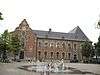 | ||
| "Michielshuis" <sup style="text-align:right; line-height:1em;
margin-left:0.3em; color:blue; cursor:help; font-family:Verdana,sans-serif;"
title=""Michielshuis"">(nl) |
Bree | Markt 8 | 51°08′29″N 5°35′48″E / 51.14150°N 5.59676°E | 70855 Info | 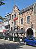 | ||
| Mansion (nl) (fr) |
Bree | Markt 13 | 51°08′28″N 5°35′48″E / 51.14104°N 5.59668°E | 70856 Info | |||
| L-shaped building Xixa (nl) (fr) |
Bree | Markt 23 | 51°08′29″N 5°35′46″E / 51.14129°N 5.59624°E | 70857 Info | |||
| house (nl) (fr) |
Bree | Meinestraat 14 | 51°08′31″N 5°35′55″E / 51.14194°N 5.59870°E | 70858 Info | |||
| Two large houses from XIX (nl) (fr) |
Bree | Nieuwstadpoort 9 | 51°08′24″N 5°35′42″E / 51.14009°N 5.59489°E | 70859 Info | |||
| Two large houses from XIX (nl) (fr) |
Bree | Nieuwstadpoort 11 | 51°08′24″N 5°35′42″E / 51.14009°N 5.59489°E | 70859 Info | |||
| Mansion (nl) (fr) |
Bree | Nieuwstadstraat 12 | 51°08′28″N 5°35′43″E / 51.14117°N 5.59519°E | 70860 Info | |||
| house (nl) (fr) |
Bree | Hoogstraat 32 | 51°08′30″N 5°35′58″E / 51.14153°N 5.59957°E | 70861 Info | |||
| Former home "the Eysere hant" <sup style="text-align:right; line-height:1em;
margin-left:0.3em; color:blue; cursor:help; font-family:Verdana,sans-serif;"
title="Voormalig huis "de Eysere Hant"">(nl) <sup style="text-align:right; line-height:1em; margin-left:0.3em; color:blue; cursor:help; font-family:Verdana,sans-serif;"
title="Ancien maison "du hant Eysere"">(fr) |
Bree | Opitterstraat 7 | 51°08′29″N 5°36′00″E / 51.14130°N 5.59991°E | 70862 Info | |||
| house (nl) (fr) |
Bree | Opitterstraat 24 | 51°08′26″N 5°36′00″E / 51.14048°N 5.60000°E | 70863 Info | |||
| house (nl) (fr) |
Bree | Opitterstraat 28 | 51°08′26″N 5°36′01″E / 51.14042°N 5.60026°E | 70864 Info | |||
| house (nl) (fr) |
Bree | Opitterstraat 32 | 51°08′26″N 5°36′02″E / 51.14046°N 5.60060°E | 70865 Info | |||
| St Job Chapel (nl) (fr) |
Bree | Oudestraat | 51°08′20″N 5°35′54″E / 51.13876°N 5.59839°E | 70866 Info | |||
| Chapel of Our Lady of Montfort (nl) (fr) |
Bree | Panhovenstraat | 51°08′02″N 5°36′58″E / 51.13376°N 5.61618°E | 70867 Info | |||
| Parish Church St. Lutgardis (nl) (fr) |
Bree | 't Hasseltkiezel | 51°08′33″N 5°38′51″E / 51.14247°N 5.64751°E | 70868 Info | 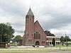 | ||
| Vogeldonskhof <sup style="text-align:right; line-height:1em;
margin-left:0.3em; color:blue; cursor:help; font-family:Verdana,sans-serif;"
title=""Vogeldonskhof"">(nl) (fr) |
Bree | 't Hasseltkiezel 33 | 51°08′36″N 5°40′53″E / 51.14338°N 5.68151°E | 70869 Info | |||
| Former refugiehuis of the Abbey of Postel (nl) (fr) |
|
Bree | Grauwe Torenwal 3 | 51°08′24″N 5°35′52″E / 51.14005°N 5.59784°E | 70870 Info | ||
| Deanery (nl) (fr) |
Bree | Vaesstraat 2 | 51°08′25″N 5°35′56″E / 51.14029°N 5.59900°E | 70871 Info | 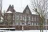 | ||
| Two identical houses wide (nl) (fr) |
Bree | Vaesstraat 3 | 51°08′26″N 5°35′57″E / 51.14069°N 5.59918°E | 70872 Info | |||
| Former kapelanij (nl) (fr) |
Bree | Vaesstraat 4 | 51°08′25″N 5°35′58″E / 51.14037°N 5.59946°E | 70873 Info | |||
| Farmstead "Patersburgerhof" <sup style="text-align:right; line-height:1em;
margin-left:0.3em; color:blue; cursor:help; font-family:Verdana,sans-serif;"
title="Hoeve "Patersburgerhof"">(nl) <sup style="text-align:right; line-height:1em; margin-left:0.3em; color:blue; cursor:help; font-family:Verdana,sans-serif;"
title="Ferme "Patersburgerhof"">(fr) |
Bree | Veldstraat 2 | 51°08′18″N 5°38′45″E / 51.13829°N 5.64588°E | 70874 Info | |||
| Memorial to the casualties of W.O. I (nl) (fr) |
Bree | Vrijthof | 51°08′29″N 5°35′52″E / 51.14132°N 5.59776°E | 70875 Info | 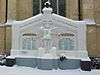 | ||
| Two civilian houses XIXd (nl) (fr) |
Bree | Vrijthof 3 | 51°08′30″N 5°35′53″E / 51.14154°N 5.59808°E | 70876 Info | |||
| Two civilian houses XIXd (nl) (fr) |
Bree | Vrijthof 4 | 51°08′30″N 5°35′53″E / 51.14154°N 5.59808°E | 70876 Info | |||
| Two houses from the late XIX (nl) (fr) |
Bree | Vrijthof 5 | 51°08′30″N 5°35′53″E / 51.14158°N 5.59803°E | 70877 Info | |||
| Two houses from the late XIX (nl) (fr) |
Bree | Vrijthof 6 | 51°08′30″N 5°35′53″E / 51.14158°N 5.59803°E | 70877 Info | |||
| Burger House (nl) (fr) |
Bree | Vrijthof 9 | 51°08′30″N 5°35′52″E / 51.14178°N 5.59772°E | 70878 Info | |||
| Augustinian Monastery and Chapel (former) (nl) (fr) |
|
Bree | Vrijthof 10 | 51°08′31″N 5°35′50″E / 51.14194°N 5.59732°E | 70879 Info | ||
| Diephuis from the 1920 (nl) (fr) |
Bree | Witte Torenstraat 10 | 51°08′37″N 5°35′59″E / 51.14363°N 5.59980°E | 70880 Info | |||
| Parish Church of Our Lady in Gerdingen (nl) (fr) |
|
Bree | Barrierstraat 6 | 51°08′51″N 5°35′18″E / 51.14760°N 5.58833°E | 71027 Info | 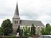 | |
| Former farm (nl) (fr) |
Bree | Barrierstraat 3 | 51°08′50″N 5°35′20″E / 51.14728°N 5.58882°E | 71028 Info | |||
| Former farm (nl) (fr) |
Bree | Barrierstraat 5 | 51°08′50″N 5°35′20″E / 51.14728°N 5.58882°E | 71028 Info | |||
| Village house from XIXd (nl) (fr) |
Bree | Barrierstraat 28 | 51°08′48″N 5°35′08″E / 51.14680°N 5.58547°E | 71029 Info | |||
| Village house from the late XIX (nl) (fr) |
Bree | Barrierstraat 47 | 51°08′41″N 5°34′52″E / 51.14465°N 5.58113°E | 71030 Info | |||
| Cast Iron Cross (nl) (fr) |
Bree | Heuvelstraat | 51°07′58″N 5°34′07″E / 51.13277°N 5.56869°E | 71031 Info | |||
| Farmstead "Cluysemanshof" <sup style="text-align:right; line-height:1em;
margin-left:0.3em; color:blue; cursor:help; font-family:Verdana,sans-serif;"
title="Hoeve "Cluysemanshof"">(nl) <sup style="text-align:right; line-height:1em; margin-left:0.3em; color:blue; cursor:help; font-family:Verdana,sans-serif;"
title="Ferme "Cluysemanshof"">(fr) |
Bree | Kluisstraat 5 | 51°07′47″N 5°35′06″E / 51.12981°N 5.58488°E | 71032 Info | |||
| Gerkenberg Monastery (nl) |
Bree | Meeuwerkiezel 88 | 51°07′55″N 5°34′48″E / 51.13189°N 5.58004°E | 71033 Info | |||
| Our Lady Chapel (nl) |
Bree | Pannenbakkersstraat | 51°08′44″N 5°34′55″E / 51.14543°N 5.58207°E | 71034 Info | |||
| Former farm (nl) (fr) |
Bree | Schoolstraat 81 | 51°08′50″N 5°35′13″E / 51.14710°N 5.58705°E | 71035 Info | |||
| St. John's Chapel (nl) (fr) |
Bree | Thijsstraat | 51°08′57″N 5°35′12″E / 51.14914°N 5.58677°E | 71036 Info | |||
| Two have (nl) (fr) |
Bree | Thijsstraat 16 | 51°08′56″N 5°35′16″E / 51.14884°N 5.58764°E | 71037 Info | |||
| Two have (nl) (fr) |
Bree | Thijsstraat 18 | 51°08′56″N 5°35′16″E / 51.14884°N 5.58764°E | 71037 Info | |||
| Truyenshof typical Kempen farm <sup style="text-align:right; line-height:1em;
margin-left:0.3em; color:blue; cursor:help; font-family:Verdana,sans-serif;"
title=""Truyenshof", typisch Kempische hoeve">(nl) |
Bree | Truyenhofstraat 1 | 51°08′24″N 5°34′41″E / 51.13992°N 5.57795°E | 71038 Info | |||
| Saint Anthony's Chapel (nl) |
Bree | Maaseikerbaan | 51°06′53″N 5°39′32″E / 51.11477°N 5.65890°E | 71040 Info | |||
| Farmstead "Veltmanshof" <sup style="text-align:right; line-height:1em;
margin-left:0.3em; color:blue; cursor:help; font-family:Verdana,sans-serif;"
title="Hoeve "Veltmanshof"">(nl) |
Bree | Maaseikerbaan 1 | 51°07′01″N 5°38′54″E / 51.11691°N 5.64839°E | 71041 Info | |||
| Pollismolen <sup style="text-align:right; line-height:1em;
margin-left:0.3em; color:blue; cursor:help; font-family:Verdana,sans-serif;"
title=""Pollismolen"">(nl) |
|
Bree | Molenstraat 48 | 51°06′56″N 5°38′05″E / 51.11561°N 5.63482°E | 71042 Info | ||
| Slagmolen <sup style="text-align:right; line-height:1em;
margin-left:0.3em; color:blue; cursor:help; font-family:Verdana,sans-serif;"
title=""Slagmolen"">(nl) |
Bree | Molenstraat 52 | 51°06′54″N 5°38′16″E / 51.11510°N 5.63780°E | 71043 Info | |||
| Farm (nl) (fr) |
Bree | Opstraat 10 | 51°06′58″N 5°38′41″E / 51.11617°N 5.64461°E | 71044 Info | |||
| Vinck Mill <sup style="text-align:right; line-height:1em;
margin-left:0.3em; color:blue; cursor:help; font-family:Verdana,sans-serif;"
title=""Vinckemolen"">(nl) |
Bree | Opstraat 14 | 51°06′57″N 5°38′39″E / 51.11586°N 5.64413°E | 71045 Info | |||
| Rectory (nl) (fr) |
|
Bree | Pater Neyenslaan 2 | 51°07′06″N 5°38′46″E / 51.11822°N 5.64619°E | 71046 Info | ||
| Former guard bridge house (nl) (fr) |
Bree | Ziepstraat 44 | 51°06′57″N 5°40′05″E / 51.11581°N 5.66797°E | 71047 Info | |||
| Chapel of Our Lady of the Sacred Heart (nl) (fr) |
Bree | Bosstraat | 51°08′05″N 5°40′09″E / 51.13459°N 5.66921°E | 71048 Info | |||
| St. Peter's Parish (nl) (fr) |
|
Bree | Dorpstraat | 51°07′36″N 5°39′36″E / 51.12672°N 5.66001°E | 71049 Info | _-_Sint-Petruskerk.jpg) | |
| Two village houses (nl) (fr) |
Bree | Dorpstraat 18 | 51°07′37″N 5°39′39″E / 51.12696°N 5.66087°E | 71050 Info | |||
| Two village houses (nl) (fr) |
Bree | Dorpstraat 20 | 51°07′37″N 5°39′39″E / 51.12696°N 5.66087°E | 71050 Info | |||
| Village house (nl) (fr) |
Bree | Dorpstraat 22 | 51°07′37″N 5°39′40″E / 51.12700°N 5.66108°E | 71051 Info | |||
| Village house from 1886 (nl) (fr) |
Bree | Dorpstraat 23 | 51°07′39″N 5°39′38″E / 51.12745°N 5.66062°E | 71052 Info | |||
| Former farm (nl) (fr) |
Bree | Dorpstraat 24 | 51°07′36″N 5°39′41″E / 51.12668°N 5.66125°E | 71053 Info | |||
| Village house from 1854 (nl) (fr) |
Bree | Dorpstraat 25 | 51°07′40″N 5°39′38″E / 51.12771°N 5.66050°E | 71054 Info | |||
| Small elongated farm (nl) (fr) |
Bree | Dorpstraat 27 | 51°07′40″N 5°39′39″E / 51.12776°N 5.66084°E | 71055 Info | |||
| Former farm of 1865 (nl) (fr) |
Bree | Dorpstraat 30 | 51°07′38″N 5°39′43″E / 51.12723°N 5.66201°E | 71056 Info | |||
| Former farm of 1885 (nl) (fr) |
Bree | Dorpstraat 29 | 51°07′40″N 5°39′40″E / 51.12783°N 5.66103°E | 71057 Info | |||
| Former school teacher's house and home section (nl) (fr) |
Bree | Dorpstraat 33 | 51°07′40″N 5°39′42″E / 51.12783°N 5.66154°E | 71058 Info | |||
| Farm (nl) (fr) |
Bree | Dorpstraat 40 | 51°07′41″N 5°39′48″E / 51.12809°N 5.66330°E | 71059 Info | |||
| "Koudhuis" <sup style="text-align:right; line-height:1em;
margin-left:0.3em; color:blue; cursor:help; font-family:Verdana,sans-serif;"
title=""Koudhuis"">(nl) |
Bree | Kerkhofstraat 7 | 51°07′37″N 5°39′30″E / 51.12707°N 5.65847°E | 71060 Info | |||
| Keyartmolen <sup style="text-align:right; line-height:1em;
margin-left:0.3em; color:blue; cursor:help; font-family:Verdana,sans-serif;"
title=""Keyartmolen"">(nl) |
|
Bree | Keyartstraat 4 | 51°07′25″N 5°39′24″E / 51.12348°N 5.65660°E | 71061 Info | ||
| Semi-closed farm (nl) (fr) |
Bree | Keyartstraat 29 | 51°07′35″N 5°39′31″E / 51.12649°N 5.65857°E | 71062 Info | |||
| Former elongated farm (nl) (fr) |
Bree | Keyartstraat 30 | 51°07′32″N 5°39′33″E / 51.12552°N 5.65912°E | 71063 Info | |||
| Closed farm (nl) (fr) |
Bree | Keyartstraat 32 | 51°07′35″N 5°39′34″E / 51.12630°N 5.65931°E | 71064 Info | |||
| Village house (nl) (fr) |
Bree | Solterweg 2 | 51°07′35″N 5°39′37″E / 51.12643°N 5.66014°E | 71066 Info | |||
| Former farmhouse XIXc (nl) (fr) |
Bree | Solterweg 4 | 51°07′35″N 5°39′37″E / 51.12642°N 5.66034°E | 71067 Info | |||
| Mill Village <sup style="text-align:right; line-height:1em;
margin-left:0.3em; color:blue; cursor:help; font-family:Verdana,sans-serif;"
title=""Dorpsmolen"">(nl) (fr) |
|
Bree | Solterweg 16 | 51°07′31″N 5°39′41″E / 51.12535°N 5.66130°E | 71068 Info | ||
| Harvester Mill <sup style="text-align:right; line-height:1em;
margin-left:0.3em; color:blue; cursor:help; font-family:Verdana,sans-serif;"
title=""Rooiermolen"">(nl) (fr) |
Bree | Opstraat 98 | 51°06′43″N 5°37′49″E / 51.11181°N 5.63021°E | 72437 Info | |||
| elongated farm "Stukkenheidehof" (nl) |
Bree | Grensstraat 1 | 51°07′56″N 5°37′09″E / 51.13227°N 5.61923°E | 86033 Info | |||
| Wrought iron cross (nl) (fr) |
Bree | Nijsenbergstraat | 51°06′57″N 5°36′35″E / 51.11590°N 5.60963°E | {{{id}}} Info | |||
| Farmstead "Straeterhof" <sup style="text-align:right; line-height:1em;
margin-left:0.3em; color:blue; cursor:help; font-family:Verdana,sans-serif;"
title="Hoeve "Straeterhof"">(nl) |
Bree | Straterhofweg 1 | 51°08′26″N 5°38′42″E / 51.14048°N 5.64500°E | 86035 Info | |||
| Farm "Kluitshof" later "Groot Kluitshof" <sup style="text-align:right; line-height:1em;
margin-left:0.3em; color:blue; cursor:help; font-family:Verdana,sans-serif;"
title="Hoeve "Kluitshof", later "Groot Kluitshof"">(nl) |
Bree | Kluitshofweg 4 | 51°07′41″N 5°34′46″E / 51.12799°N 5.57932°E | 86036 Info | |||
| Wrought iron cross (nl) (fr) |
Bree | Meeuwerkiezel | 51°07′36″N 5°34′06″E / 51.12660°N 5.56839°E | 86037 Info | |||
| Cross (nl) |
Bree | Muizendijkstraat | 51°06′39″N 5°34′39″E / 51.11090°N 5.57759°E | 86038 Info | |||
| Memorial to the casualties of W.O. I (nl) (fr) |
Bree | Siemenstraat | 51°08′38″N 5°35′23″E / 51.14387°N 5.58973°E | 86039 Info | |||
| farm "Stukkenheidehof" <sup style="text-align:right; line-height:1em;
margin-left:0.3em; color:blue; cursor:help; font-family:Verdana,sans-serif;"
title="Hoeve "Stukkenheidehof"">(nl) |
Bree | Grensstraat 2 | 51°08′01″N 5°37′28″E / 51.13366°N 5.62431°E | 86040 Info | |||
| Chapel of Our Lady Comforter of the Afflicted (nl) (fr) |
|
Bree | Opitterkiezel 200 | 51°07′15″N 5°38′17″E / 51.12093°N 5.63807°E | 86041 Info | ||
| Convent and School (nl) (fr) |
Bree | Opitterkiezel 211 | 51°07′10″N 5°38′34″E / 51.11935°N 5.64274°E | 86042 Info | |||
| Farm with old establishment (nl) (fr) |
Bree | Rorenweg 16 | 51°07′46″N 5°38′08″E / 51.12954°N 5.63544°E | 86043 Info | |||
| Farm with old establishment (nl) (fr) |
Bree | Rorenweg 24 | 51°07′35″N 5°38′27″E / 51.12625°N 5.64089°E | 86044 Info | |||
| Parish Church St. Trudo (nl) (fr) |
|
Bree | Itterplein 1 | 51°07′03″N 5°38′47″E / 51.11759°N 5.64625°E | 88644 Info | 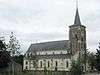 | |
| Restored village house (nl) (fr) |
|
Bree | Itterplein 1 | 51°07′03″N 5°38′47″E / 51.11759°N 5.64625°E | 88645 Info | ||
| Single eclectic mansion (nl) (fr) |
Bree | Itterplein 20 | 51°07′00″N 5°38′45″E / 51.11677°N 5.64593°E | 88646 Info | |||
| Brewery St. Joseph (nl) (fr) |
Bree | Itterplein 24 | 51°07′01″N 5°38′49″E / 51.11694°N 5.64693°E | 88647 Info | |||
| Former section house (nl) (fr) |
Bree | Itterplein 26 | 51°07′00″N 5°38′50″E / 51.11669°N 5.64725°E | 88648 Info | |||
| Wrought iron cross (nl) (fr) |
Bree | Rorenweg | 51°07′22″N 5°38′26″E / 51.12268°N 5.64065°E | 88649 Info |
See also
| Wikimedia Commons has media related to Onroerend erfgoed in Bree, Belgium. |