List of protected heritage sites in As, Belgium
This table shows an overview of the protected heritage sites in the Flemish town As, Belgium. This list is part of Belgium's national heritage.
| Object |
Status? |
Year/architect |
Town/section |
Address |
Coordinates |
Number? |
Image |
|---|---|---|---|---|---|---|---|
| Parish Church St. Aldegondis (nl) (fr) |
|
As | Kerkpad | 51°00′31″N 5°35′08″E / 51.00863°N 5.58565°E | 21376 Info |  | |
| elongated farm with farm mansion (nl) (fr) |
As | Dorpsstraat 26 | 51°00′29″N 5°35′10″E / 51.00794°N 5.58620°E | 21379 Info | |||
| Farmer manor house (nl) (fr) |
As | Dorpsstraat 27 | 51°00′27″N 5°35′10″E / 51.00737°N 5.58619°E | 21380 Info | |||
| House (nl) (fr) |
As | Dorpsstraat 28 | 51°00′29″N 5°35′10″E / 51.00798°N 5.58600°E | 21381 Info | |||
| chapel (nl) (fr) |
As | Duinstraat | 51°00′43″N 5°34′16″E / 51.01193°N 5.57116°E | 21383 Info | |||
| elongated farm (nl) (fr) |
As | Duinstraat 29 | 51°00′42″N 5°34′16″E / 51.01161°N 5.57121°E | 21385 Info | |||
| St. Theresa Parish church dating from 1950 (nl) (fr) |
As | Kerkplein | 51°00′22″N 5°35′02″E / 51.00601°N 5.58401°E | 21387 Info | 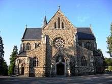 | ||
| elongated farm (nl) (fr) |
As | Klaverbergstraat 9 | 51°00′35″N 5°33′28″E / 51.00961°N 5.55764°E | 21388 Info | |||
| Farmhouse with separate components (nl) (fr) |
As | Neereinde 3 | 51°00′10″N 5°34′54″E / 51.00284°N 5.58157°E | 21389 Info | |||
| elongated farm (nl) (fr) |
As | Neereinde 5 | 51°00′09″N 5°34′56″E / 51.00255°N 5.58233°E | 21390 Info | |||
| elongated farm (nl) (fr) |
As | Neereinde 7 | 51°00′09″N 5°34′56″E / 51.00255°N 5.58233°E | 21390 Info | |||
| Former elongated farm (nl) (fr) |
As | Neereinde 6 | 51°00′08″N 5°34′54″E / 51.00221°N 5.58175°E | 21391 Info | |||
| Former elongated farm (nl) (fr) |
As | Neereinde 8 | 51°00′08″N 5°34′54″E / 51.00221°N 5.58175°E | 21391 Info | |||
| elongated farm of 1867 (nl) (fr) |
As | Nieuwebeekstraat 9 | 51°00′29″N 5°34′55″E / 51.00795°N 5.58202°E | 21392 Info | |||
| New mill, grain watermill (nl) (fr) |
|
As | André Dumontlaan 17 | 51°00′37″N 5°34′53″E / 51.01021°N 5.58138°E | 21393 Info | ||
| Watermill "Old Mill" <sup style="text-align:right; line-height:1em;
margin-left:0.3em; color:blue; cursor:help; font-family:Verdana,sans-serif;"
title="Watermolen "Oude Molen"">(nl) <sup style="text-align:right; line-height:1em; margin-left:0.3em; color:blue; cursor:help; font-family:Verdana,sans-serif;"
title="Moulin à eau "Old Mill"">(fr) |
|
As | Oude Molenweg 69 | 51°01′02″N 5°35′18″E / 51.01721°N 5.58842°E | 21395 Info | ||
| St. Joseph Chapel of 1865 (nl) (fr) |
As | Grotstraat | 51°01′20″N 5°36′03″E / 51.02211°N 5.60091°E | 21396 Info | |||
| Caster Farm (nl) (fr) |
As | Grotstraat 70 | 51°01′20″N 5°36′06″E / 51.02236°N 5.60163°E | 21397 Info | |||
| U-shaped farm (nl) (fr) |
As | Grotstraat 29 | 51°01′05″N 5°35′54″E / 51.01798°N 5.59825°E | 21398 Info | |||
| Farmer manor house (nl) (fr) |
As | Hoogstraat 121 | 51°00′57″N 5°36′05″E / 51.01594°N 5.60141°E | 21401 Info | |||
| elongated farm (nl) (fr) |
As | Hoogstraat 276 | 51°01′40″N 5°36′53″E / 51.02788°N 5.61480°E | 21403 Info | |||
| elongated farm (nl) (fr) |
As | Schutterijstraat 20 | 51°01′46″N 5°36′36″E / 51.02931°N 5.60992°E | 21404 Info | |||
| elongated farm (nl) (fr) |
As | Caelenbergstraat 38 | 51°01′52″N 5°36′27″E / 51.03108°N 5.60743°E | 21406 Info | |||
| elongated farm (nl) (fr) |
As | Karel Theunissenlaan 15 | 51°01′09″N 5°35′00″E / 51.01912°N 5.58334°E | 83612 Info | |||
| As train station (nl) (fr) |
|
As | Stationsstraat | 51°00′19″N 5°36′10″E / 51.00539°N 5.60264°E | 200283 Info | 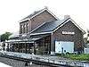 | |
| Military flight school and later children's colony (nl) (fr) |
As | Bilzerweg 88 | 206923 Info | ||||
| St. Hubert Chapel (nl) (fr) |
As | Oeleinderheide | 212746 Info |
See also
| Wikimedia Commons has media related to Onroerend erfgoed in As, Belgium. |
References
This article is issued from Wikipedia - version of the 10/30/2015. The text is available under the Creative Commons Attribution/Share Alike but additional terms may apply for the media files.