List of listed buildings in Kirkhill, Highland
This is a list of listed buildings in the parish of Kirkhill in Highland, Scotland.
List
| Name |
Location |
Date Listed |
Grid Ref. [note 1] |
Geo-coordinates |
Notes |
HB Number [note 2] |
Image |
| Reelig House Gate Lodge And Gate Piers |
|
|
|
57°27′46″N 4°24′43″W / 57.462726°N 4.411905°W / 57.462726; -4.411905 (Reelig House Gate Lodge And Gate Piers) |
Category C(S) |
7822 |

|
| Kirkhill, Wardlaw House (Former Church Of Scotland Manse) |
|
|
|
57°28′38″N 4°25′10″W / 57.477209°N 4.419532°W / 57.477209; -4.419532 (Kirkhill, Wardlaw House (Former Church Of Scotland Manse)) |
Category B |
7814 |
|
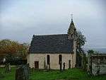
| Kirkhill, Old Wardlaw Church With Lovat Burial Aisle And Burial Ground |
|
|
|
57°28′42″N 4°25′14″W / 57.478323°N 4.420457°W / 57.478323; -4.420457 (Kirkhill, Old Wardlaw Church With Lovat Burial Aisle And Burial Ground) |
Category A |
7815 |
 Upload another image
|
| Newton House Dovecote |
|
|
|
57°28′36″N 4°23′58″W / 57.476722°N 4.399399°W / 57.476722; -4.399399 (Newton House Dovecote) |
Category B |
7819 |
|
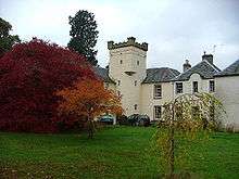
| Achnagairn House |
|
|
|
57°28′16″N 4°24′49″W / 57.471087°N 4.413557°W / 57.471087; -4.413557 (Achnagairn House) |
Category B |
7807 |
.jpg) Upload another image
|
| Moniack Castle |
|
|
|
57°27′35″N 4°24′56″W / 57.459737°N 4.415443°W / 57.459737; -4.415443 (Moniack Castle) |
Category B |
7818 |
 Upload another image
|
| Reelig House And Walled Garden |
|
|
|
57°27′35″N 4°24′15″W / 57.459825°N 4.404294°W / 57.459825; -4.404294 (Reelig House And Walled Garden) |
Category B |
7821 |
.jpg) Upload another image
|
| Birchwood, Lentran Muir Of Ord Greenhouse |
|
|
|
57°30′59″N 4°17′37″W / 57.516322°N 4.293642°W / 57.516322; -4.293642 (Birchwood, Lentran Muir Of Ord Greenhouse) |
Category C(S) |
7824 |
|
| Dunballoch |
|
|
|
57°28′12″N 4°27′51″W / 57.47007°N 4.464225°W / 57.47007; -4.464225 (Dunballoch) |
Category B |
7811 |
|
| Reelig Bridge Over The Moniack Burn |
|
|
|
57°27′46″N 4°24′45″W / 57.462686°N 4.412586°W / 57.462686; -4.412586 (Reelig Bridge Over The Moniack Burn) |
Category C(S) |
7823 |
 Upload another image
|
| Balblair House |
|
|
|
57°28′40″N 4°26′39″W / 57.477891°N 4.444233°W / 57.477891; -4.444233 (Balblair House) |
Category B |
7810 |
|
| Lentran House |
|
|
|
57°28′26″N 4°22′28″W / 57.473935°N 4.374331°W / 57.473935; -4.374331 (Lentran House) |
Category B |
7817 |
.jpg) Upload another image
|
| Achnagairn, East Lodge |
|
|
|
57°28′27″N 4°24′56″W / 57.474086°N 4.415539°W / 57.474086; -4.415539 (Achnagairn, East Lodge) |
Category B |
7808 |
|
| Phopachy |
|
|
|
57°29′02″N 4°19′44″W / 57.483976°N 4.328834°W / 57.483976; -4.328834 (Phopachy) |
Category B |
7820 |
|
| Achnagairn West Lodge |
|
|
|
57°28′21″N 4°25′09″W / 57.472586°N 4.419243°W / 57.472586; -4.419243 (Achnagairn West Lodge) |
Category B |
7809 |
|
| Englishton House |
|
|
|
57°28′35″N 4°19′11″W / 57.476399°N 4.319678°W / 57.476399; -4.319678 (Englishton House) |
Category B |
7812 |
|
| Kirkhill, Wardlaw Parish Church Of Scotland |
|
|
|
57°28′33″N 4°24′53″W / 57.475901°N 4.414608°W / 57.475901; -4.414608 (Kirkhill, Wardlaw Parish Church Of Scotland) |
Category B |
7813 |
|
| Kirkton Burial Ground |
|
|
|
57°28′32″N 4°19′38″W / 57.475587°N 4.327166°W / 57.475587; -4.327166 (Kirkton Burial Ground) |
Category C(S) |
7816 |
|
Key
The scheme for classifying buildings in Scotland is:
- Category A: "buildings of national or international importance, either architectural or historic, or fine little-altered examples of some particular period, style or building type."[1]
- Category B: "buildings of regional or more than local importance, or major examples of some particular period, style or building type which may have been altered."[1]
- Category C(S): "buildings of local importance, lesser examples of any period, style, or building type, as originally constructed or moderately altered; and simple traditional buildings which group well with others in categories A and B."[1]
There are approximately 47,400 listed buildings in Scotland. Of these, around 8 per cent (some 3,800) are Category A, and 51 per cent (24,000) are Category B, with the rest listed at Category C(s).[2]
See also
Notes
References