List of immovable heritage sites in Hamont-Achel
This table shows an overview of the immovable heritage sites in the Flemish town Hamont-Achel. This list is part of Belgium's national heritage.
| Object |
Status? |
Year/architect |
Town/section |
Address |
Coordinates |
Number? |
Image |
|---|---|---|---|---|---|---|---|
| Wooden cross with cast iron figure of Christ (nl) (fr) |
Hamont-Achel | Achelpoort | 51°15′04″N 5°32′33″E / 51.25108°N 5.54250°E | 79993 Info | |||
| House (nl) |
Hamont-Achel | Kapelstraat 4 | 51°15′08″N 5°32′26″E / 51.25220°N 5.54066°E | 79994 Info | |||
| House (nl) |
Hamont-Achel | Achelpoort 12 | 51°15′06″N 5°32′32″E / 51.25180°N 5.54230°E | 79995 Info | |||
| The Boerke (Bocholt) <sup style="text-align:right; line-height:1em;
margin-left:0.3em; color:blue; cursor:help; font-family:Verdana,sans-serif;"
title=""Het Boerke (van Bocholt)"">(nl) (fr) |
Hamont-Achel | Kapelstraat 2 | 51°15′08″N 5°32′27″E / 51.25229°N 5.54079°E | 79996 Info | |||
| elongated farm (nl) (fr) |
Hamont-Achel | Achterhoek 9 | 51°14′38″N 5°31′35″E / 51.24379°N 5.52634°E | 79997 Info | |||
| elongated farm (nl) (fr) |
Hamont-Achel | Beverbeek 12 | 51°15′55″N 5°31′34″E / 51.26516°N 5.52621°E | 79998 Info | |||
| Castle Beverbeek (nl) (fr) |
Hamont-Achel | Beverbeek 19 | 51°16′35″N 5°30′56″E / 51.27651°N 5.51544°E | 79999 Info | |||
| Chapel of the Black Sisters (nl) (fr) |
Hamont-Achel | Bosstraat 7 | 51°14′58″N 5°32′26″E / 51.24938°N 5.54057°E | 80001 Info | |||
| Single building ordinance: workhouse-house (nl) (fr) |
Hamont-Achel | Bosstraat 48 | 51°14′57″N 5°32′12″E / 51.24910°N 5.53657°E | 80002 Info | |||
| Detached house, double house (nl) (fr) |
Hamont-Achel | Bosstraat 73 | 51°14′51″N 5°31′58″E / 51.24760°N 5.53290°E | 80004 Info | |||
| Single elongated farm (nl) (fr) |
Hamont-Achel | Bosstraat 105 | 51°14′51″N 5°31′43″E / 51.24750°N 5.52870°E | 80005 Info | |||
| store (nl) (fr) |
Hamont-Achel | Brouwersstraat 1 | 51°15′06″N 5°32′42″E / 51.25155°N 5.54510°E | 80006 Info | |||
| store (nl) (fr) |
Hamont-Achel | Brouwersstraat 3 | 51°15′06″N 5°32′42″E / 51.25155°N 5.54510°E | 80006 Info | |||
| store (nl) (fr) |
Hamont-Achel | Brouwersstraat 5 | 51°15′06″N 5°32′42″E / 51.25155°N 5.54510°E | 80006 Info | |||
| store (nl) (fr) |
Hamont-Achel | Brouwersstraat 7 | 51°15′06″N 5°32′42″E / 51.25155°N 5.54510°E | 80006 Info | |||
| Wooden cross with witbeschilderde cast iron figure of Christ (nl) (fr) |
Hamont-Achel | Budelpoort | 51°15′07″N 5°32′50″E / 51.25196°N 5.54734°E | 80007 Info | |||
| House, double house (nl) (fr) |
Hamont-Achel | Budelpoort 34 | 51°15′10″N 5°33′00″E / 51.25269°N 5.55013°E | 80008 Info | |||
| Tollhouse (former) (nl) (fr) |
Hamont-Achel | Budelpoort 44 | 51°15′10″N 5°33′03″E / 51.25281°N 5.55095°E | 80009 Info | |||
| Formerly "Bierkasteel", now "Erkenhof" <sup style="text-align:right; line-height:1em;
margin-left:0.3em; color:blue; cursor:help; font-family:Verdana,sans-serif;"
title="Vroeger "Bierkasteel", nu "Erkenhof"">(nl) <sup style="text-align:right; line-height:1em; margin-left:0.3em; color:blue; cursor:help; font-family:Verdana,sans-serif;"
title="Anciennement "Bierkasteel", maintenant "Erkenhof"">(fr) |
Hamont-Achel | Budelpoort 47 | 51°15′14″N 5°33′05″E / 51.25390°N 5.55127°E | 80010 Info | |||
| Salvator's College (former), "Wico Campus Salvator" <sup style="text-align:right; line-height:1em;
margin-left:0.3em; color:blue; cursor:help; font-family:Verdana,sans-serif;"
title="Salvatorcollege (voormalig), "Wico Campus Salvator"">(nl) <sup style="text-align:right; line-height:1em; margin-left:0.3em; color:blue; cursor:help; font-family:Verdana,sans-serif;"
title="Salvator Collège (ancien), "Campus Wico Salvator"">(fr) |
Hamont-Achel | Collegestraat 25 | 51°13′55″N 5°32′28″E / 51.23202°N 5.54118°E | 80011 Info | |||
| Two linked houses (nl) (fr) |
Hamont-Achel | Groenstraat 47 | 51°14′50″N 5°32′56″E / 51.24722°N 5.54901°E | 80012 Info | |||
| Two linked houses (nl) (fr) |
Hamont-Achel | Groenstraat 49 | 51°14′50″N 5°32′56″E / 51.24722°N 5.54901°E | 80012 Info | |||
| Single elongated farm (nl) (fr) |
Hamont-Achel | Grote Haart 22 | 51°15′16″N 5°31′18″E / 51.25432°N 5.52153°E | 80013 Info | |||
| Boskapel Our Lady of Perpetual-Assistance- (nl) (fr) |
Hamont-Achel | Hees | 51°14′29″N 5°30′55″E / 51.24149°N 5.51525°E | 80014 Info | |||
| Double House (nl) |
Hamont-Achel | Hoogstraat 7 | 51°15′05″N 5°32′37″E / 51.25131°N 5.54357°E | 80016 Info | |||
| Double House (nl) |
Hamont-Achel | Hoogstraat 9 | 51°15′05″N 5°32′37″E / 51.25131°N 5.54357°E | 80016 Info | |||
| Former kapelanie, now a private residence (nl) (fr) |
Hamont-Achel | Hoogstraat 33 | 51°15′08″N 5°32′41″E / 51.25224°N 5.54482°E | 80017 Info | |||
| elongated farm (nl) (fr) |
Hamont-Achel | Kapelstraat 88 | 51°15′12″N 5°31′44″E / 51.25344°N 5.52890°E | 80018 Info | |||
| presbytery St. Lawrence Church (nl) (fr) |
|
Hamont-Achel | Kerkstraat 1 | 51°15′06″N 5°32′47″E / 51.25173°N 5.54636°E | 80019 Info |  | |
| Town Pump (nl) (fr) |
Hamont-Achel | Kerkstraat | 51°15′06″N 5°32′50″E / 51.25175°N 5.54713°E | 80020 Info | |||
| Former border cafe "The Running Tap" <sup style="text-align:right; line-height:1em;
margin-left:0.3em; color:blue; cursor:help; font-family:Verdana,sans-serif;"
title="Voormalig grenscafé "Het Lopend Kraantje"">(nl) <sup style="text-align:right; line-height:1em; margin-left:0.3em; color:blue; cursor:help; font-family:Verdana,sans-serif;"
title="Café de l'ancienne frontière "le robinet ouvert"">(fr) |
Hamont-Achel | Keunenlaan 4 | 51°15′13″N 5°33′06″E / 51.25348°N 5.55172°E | 80021 Info | |||
| Detached farmhouse with separate components (nl) (fr) |
Hamont-Achel | Kleine Haart 30 | 51°15′26″N 5°31′11″E / 51.25724°N 5.51977°E | 80022 Info | |||
| Remnants of the Ursuline Convent "Stalleken van Bethlehem" <sup style="text-align:right; line-height:1em;
margin-left:0.3em; color:blue; cursor:help; font-family:Verdana,sans-serif;"
title="Restanten van het Ursulinenklooster "Stalleken van Bethlehem"">(nl) (fr) |
|
Hamont-Achel | Kloosterstraat 2 | 51°15′03″N 5°32′52″E / 51.25073°N 5.54771°E | 80023 Info | ||
| Chapel of the Ursulines convent (nl) (fr) |
|
Hamont-Achel | Kloosterstraat | 51°15′04″N 5°32′54″E / 51.25108°N 5.54841°E | 80024 Info | ||
| Subsidized Free Primary School, since 1993, "De Buitinge" <sup style="text-align:right; line-height:1em;
margin-left:0.3em; color:blue; cursor:help; font-family:Verdana,sans-serif;"
title="Gesubsidieerde Vrije Lagere School, sinds 1993 "De Buitinge"">(nl) (fr) |
Hamont-Achel | Kloosterstraat 2 | 51°15′03″N 5°32′52″E / 51.25071°N 5.54767°E | 80025 Info | |||
| Nursery school (nl) (fr) |
Hamont-Achel | Kloosterstraat | 51°15′03″N 5°32′49″E / 51.25073°N 5.54698°E | 80026 Info | |||
| School for girls (nl) (fr) |
Hamont-Achel | Kloosterstraat | 51°15′01″N 5°32′48″E / 51.25025°N 5.54653°E | 80027 Info | |||
| Single elongated farm (nl) |
Hamont-Achel | Krekelhoeve 3 | 51°14′56″N 5°31′08″E / 51.24883°N 5.51899°E | 80028 Info | |||
| Single elongated farm (nl) (fr) |
Hamont-Achel | Krekelhoeve 7 | 51°14′58″N 5°31′12″E / 51.24946°N 5.51997°E | 80029 Info | |||
| Salvator Mundi Parish (nl) (fr) |
Hamont-Achel | 't Lo | 51°14′00″N 5°32′22″E / 51.23347°N 5.53946°E | 80030 Info | |||
| Subsidized Free Primary Hamont-Lo (nl) (fr) |
Hamont-Achel | 't Lo 13 | 51°14′03″N 5°32′30″E / 51.23417°N 5.54159°E | 80031 Info | |||
| Single double house (nl) (fr) |
Hamont-Achel | 't Lo 46 | 51°13′56″N 5°32′20″E / 51.23226°N 5.53900°E | 80032 Info | |||
| elongated farm (nl) (fr) |
Hamont-Achel | Lozenweg 10 | 51°14′30″N 5°32′54″E / 51.24176°N 5.54824°E | 80033 Info | |||
| The Castle of Lo de l'Escaille (nl) (fr) |
|
Hamont-Achel | Lozenweg 100 | 51°13′32″N 5°32′47″E / 51.22561°N 5.54640°E | 80034 Info | ||
| The Castle of Lo de l'Escaille (nl) (fr) |
|
Hamont-Achel | Lozenweg 102 | 51°13′32″N 5°32′47″E / 51.22561°N 5.54640°E | 80034 Info | ||
| The Castle of Lo or "de l'Escaille" (nl) (fr) |
|
Hamont-Achel | Lozenweg 104 | 51°13′32″N 5°32′47″E / 51.22561°N 5.54640°E | 80034 Info | ||
| Napoleon's Mill <sup style="text-align:right; line-height:1em;
margin-left:0.3em; color:blue; cursor:help; font-family:Verdana,sans-serif;"
title=""Napoleonsmolen"">(nl) (fr) |
|
Hamont-Achel | Dr. Mathijsenstraat 3 | 51°15′03″N 5°32′23″E / 51.25087°N 5.53973°E | 80035 Info | ||
| elongated farm (nl) (fr) |
Hamont-Achel | Mulk 63 | 51°15′49″N 5°33′03″E / 51.26358°N 5.55075°E | 80036 Info | |||
| elongated farm (nl) (fr) |
Hamont-Achel | Mulk 116 | 51°15′48″N 5°32′25″E / 51.26336°N 5.54022°E | 80037 Info | |||
| elongated farm (nl) (fr) |
Hamont-Achel | Mulk 120 | 51°15′48″N 5°32′18″E / 51.26321°N 5.53827°E | 80038 Info | |||
| Pump platform of stone (nl) (fr) |
Hamont-Achel | Stad | 51°15′04″N 5°32′44″E / 51.25123°N 5.54544°E | 80039 Info | |||
| House Geusens <sup style="text-align:right; line-height:1em;
margin-left:0.3em; color:blue; cursor:help; font-family:Verdana,sans-serif;"
title=""Huis Geusens"">(nl) |
|
Hamont-Achel | Stad 4 | 51°15′02″N 5°32′36″E / 51.25048°N 5.54337°E | 80040 Info | ||
| House Spaas <sup style="text-align:right; line-height:1em;
margin-left:0.3em; color:blue; cursor:help; font-family:Verdana,sans-serif;"
title=""Huis Spaas"">(nl) |
|
Hamont-Achel | Stad 21 | 51°15′05″N 5°32′40″E / 51.25141°N 5.54446°E | 80042 Info | ||
| House Gijbels <sup style="text-align:right; line-height:1em;
margin-left:0.3em; color:blue; cursor:help; font-family:Verdana,sans-serif;"
title=""Huis Gijbels"">(nl) |
|
Hamont-Achel | Stad 27 | 51°15′05″N 5°32′41″E / 51.25148°N 5.54472°E | 80043 Info | ||
| Hegge House <sup style="text-align:right; line-height:1em;
margin-left:0.3em; color:blue; cursor:help; font-family:Verdana,sans-serif;"
title=""Huis Hegge"">(nl) |
Hamont-Achel | Stad 32 | 51°15′03″N 5°32′41″E / 51.25076°N 5.54483°E | 80044 Info | |||
| De Pool House or "Rijcken" <sup style="text-align:right; line-height:1em;
margin-left:0.3em; color:blue; cursor:help; font-family:Verdana,sans-serif;"
title=""Huis De Poel" of "Rijcken"">(nl) |
|
Hamont-Achel | Stad 37 | 51°15′06″N 5°32′44″E / 51.25157°N 5.54565°E | 80045 Info | ||
| House Cuppens <sup style="text-align:right; line-height:1em;
margin-left:0.3em; color:blue; cursor:help; font-family:Verdana,sans-serif;"
title=""Huis Cuppens"">(nl) |
|
Hamont-Achel | Stad 39 | 51°15′06″N 5°32′45″E / 51.25155°N 5.54583°E | 80046 Info | ||
| "Huis Van Engelen" <sup style="text-align:right; line-height:1em;
margin-left:0.3em; color:blue; cursor:help; font-family:Verdana,sans-serif;"
title=""Huis Van Engelen"">(nl) |
|
Hamont-Achel | Stad 44 | 51°15′03″N 5°32′46″E / 51.25092°N 5.54622°E | 80047 Info | ||
| House"De Gulden Poort" <sup style="text-align:right; line-height:1em;
margin-left:0.3em; color:blue; cursor:help; font-family:Verdana,sans-serif;"
title="Huis "De Gulden Poort"">(nl) |
|
Hamont-Achel | Stadswaag 8 | 51°15′02″N 5°32′33″E / 51.25042°N 5.54241°E | 80048 Info | ||
| House (nl) |
Hamont-Achel | Stadswaag 20 | 51°15′00″N 5°32′34″E / 51.24990°N 5.54291°E | 80049 Info | |||
| former hotel and restaurant "Neuf" <sup style="text-align:right; line-height:1em;
margin-left:0.3em; color:blue; cursor:help; font-family:Verdana,sans-serif;"
title="Breedhuis, eertijds hotel en restaurant "Neuf"">(nl) |
Hamont-Achel | Stationsplein 4 | 51°14′48″N 5°32′41″E / 51.24679°N 5.54479°E | 80051 Info | |||
| House (nl) |
Hamont-Achel | Stationsstraat 12 | 51°14′54″N 5°32′38″E / 51.24835°N 5.54376°E | 80052 Info | |||
| House, double house (nl) (fr) |
Hamont-Achel | Stationsstraat 18 | 51°14′53″N 5°32′38″E / 51.24809°N 5.54375°E | 80053 Info | |||
| "Teutenwoning Henri Rijcken" <sup style="text-align:right; line-height:1em;
margin-left:0.3em; color:blue; cursor:help; font-family:Verdana,sans-serif;"
title=""Teutenwoning Henri Rijcken"">(nl) |
Hamont-Achel | Stationsstraat 28 | 51°14′51″N 5°32′38″E / 51.24757°N 5.54398°E | 80054 Info | |||
| Saint Therese Chapel Mulk (nl) (fr) |
Hamont-Achel | Toomstraat | 51°15′53″N 5°32′58″E / 51.26479°N 5.54948°E | 80055 Info | |||
| Cast iron boundary (nl) (fr) |
Hamont-Achel | Toomstraat | 51°16′01″N 5°33′19″E / 51.26683°N 5.55541°E | 80056 Info | |||
| Column-shaped water tower of 1957 (nl) (fr) |
Hamont-Achel | Watertorenstraat | 51°14′44″N 5°31′38″E / 51.24568°N 5.52710°E | 80058 Info | |||
| Sacred Heart Chapel of the district Achterhoek (nl) (fr) |
Hamont-Achel | Windmolenstraat | 51°14′32″N 5°32′06″E / 51.24218°N 5.53503°E | 80059 Info | |||
| Single, elongated farm (nl) (fr) |
Hamont-Achel | Winter 9 | 51°14′06″N 5°31′26″E / 51.23509°N 5.52381°E | 80060 Info | |||
| Detached village house (nl) (fr) |
Hamont-Achel | Achel Statie 7 | 51°16′05″N 5°28′28″E / 51.26795°N 5.47447°E | 80061 Info | |||
| Former customs house "De Acht Zaligheden" <sup style="text-align:right; line-height:1em;
margin-left:0.3em; color:blue; cursor:help; font-family:Verdana,sans-serif;"
title="Vroegere douanewoningen "De Acht Zaligheden"">(nl) (fr) |
Hamont-Achel | Achel Statie 11 | 51°16′06″N 5°28′26″E / 51.26837°N 5.47393°E | 80062 Info | |||
| Former customs house "De Acht Zaligheden" <sup style="text-align:right; line-height:1em;
margin-left:0.3em; color:blue; cursor:help; font-family:Verdana,sans-serif;"
title="Vroegere douanewoningen "De Acht Zaligheden"">(nl) (fr) |
Hamont-Achel | Achel Statie 13 | 51°16′06″N 5°28′26″E / 51.26837°N 5.47393°E | 80062 Info | |||
| Former customs house "De Acht Zaligheden" <sup style="text-align:right; line-height:1em;
margin-left:0.3em; color:blue; cursor:help; font-family:Verdana,sans-serif;"
title="Vroegere douanewoningen "De Acht Zaligheden"">(nl) (fr) |
Hamont-Achel | Achel Statie 15 | 51°16′06″N 5°28′26″E / 51.26837°N 5.47393°E | 80062 Info | |||
| Former customs house "De Acht Zaligheden" <sup style="text-align:right; line-height:1em;
margin-left:0.3em; color:blue; cursor:help; font-family:Verdana,sans-serif;"
title="Vroegere douanewoningen "De Acht Zaligheden"">(nl) (fr) |
Hamont-Achel | Achel Statie 17 | 51°16′06″N 5°28′26″E / 51.26837°N 5.47393°E | 80062 Info | |||
| Former customs house "De Acht Zaligheden" <sup style="text-align:right; line-height:1em;
margin-left:0.3em; color:blue; cursor:help; font-family:Verdana,sans-serif;"
title="Vroegere douanewoningen "De Acht Zaligheden"">(nl) (fr) |
Hamont-Achel | Achel Statie 19 | 51°16′06″N 5°28′26″E / 51.26837°N 5.47393°E | 80062 Info | |||
| Former customs house "De Acht Zaligheden" <sup style="text-align:right; line-height:1em;
margin-left:0.3em; color:blue; cursor:help; font-family:Verdana,sans-serif;"
title="Vroegere douanewoningen "De Acht Zaligheden"">(nl) (fr) |
Hamont-Achel | Achel Statie 21 | 51°16′06″N 5°28′26″E / 51.26837°N 5.47393°E | 80062 Info | |||
| Former customs house "De Acht Zaligheden" <sup style="text-align:right; line-height:1em;
margin-left:0.3em; color:blue; cursor:help; font-family:Verdana,sans-serif;"
title="Vroegere douanewoningen "De Acht Zaligheden"">(nl) (fr) |
Hamont-Achel | Achel Statie 23 | 51°16′06″N 5°28′26″E / 51.26837°N 5.47393°E | 80062 Info | |||
| Former customs house "De Acht Zaligheden" <sup style="text-align:right; line-height:1em;
margin-left:0.3em; color:blue; cursor:help; font-family:Verdana,sans-serif;"
title="Vroegere douanewoningen "De Acht Zaligheden"">(nl) (fr) |
Hamont-Achel | Achel Statie 25 | 51°16′06″N 5°28′26″E / 51.26837°N 5.47393°E | 80062 Info | |||
| Detached town house "Les Agnelets" <sup style="text-align:right; line-height:1em;
margin-left:0.3em; color:blue; cursor:help; font-family:Verdana,sans-serif;"
title="Alleenstaand burgerhuis "Les Agnelets"">(nl) <sup style="text-align:right; line-height:1em; margin-left:0.3em; color:blue; cursor:help; font-family:Verdana,sans-serif;"
title="Maison de ville individuelle "Les Agnelets"">(fr) |
Hamont-Achel | Achel Statie 35 | 51°16′09″N 5°28′25″E / 51.26916°N 5.47357°E | 80063 Info | |||
| Single residential house (nl) (fr) |
Hamont-Achel | Achel Statie 50 | 51°16′21″N 5°28′14″E / 51.27259°N 5.47048°E | 80064 Info | |||
| Single residential house (nl) (fr) |
Hamont-Achel | Achel Statie 78 | 51°16′28″N 5°28′12″E / 51.27445°N 5.46987°E | 80065 Info | |||
| Detached former farmhouse elongated (nl) (fr) |
Hamont-Achel | Bergeind 2 | 51°14′58″N 5°28′52″E / 51.24958°N 5.48113°E | 80067 Info | |||
| Wijkschool of Achel Station (nl) (fr) |
Hamont-Achel | Berkenstraat 2 | 51°16′22″N 5°28′22″E / 51.27265°N 5.47286°E | 80068 Info | |||
| "Beverbeekhoeve" or "Grote Hoeve" <sup style="text-align:right; line-height:1em;
margin-left:0.3em; color:blue; cursor:help; font-family:Verdana,sans-serif;"
title=""Beverbeekhoeve" of "Grote Hoeve", voormalige laathoeve">(nl) |
|
Hamont-Achel | Beverbeek 21 | 51°16′43″N 5°30′47″E / 51.27864°N 5.51299°E | 80069 Info | ||
| Former forester's house of the castle Genes Pants (nl) (fr) |
Hamont-Achel | Catharinadal | 51°15′13″N 5°29′06″E / 51.25374°N 5.48493°E | 80070 Info | |||
| Former forester's house of the castle Genes Pants (nl) (fr) |
Hamont-Achel | Catharinadal 1 | 51°15′13″N 5°29′06″E / 51.25374°N 5.48493°E | 80070 Info | |||
| remnants of "Catharinadal" <sup style="text-align:right; line-height:1em;
margin-left:0.3em; color:blue; cursor:help; font-family:Verdana,sans-serif;"
title="Spinhuis, overblijfsel van "Catharinadal"">(nl) |
Hamont-Achel | Catharinadal | 51°15′13″N 5°29′07″E / 51.25356°N 5.48541°E | 80071 Info | |||
| Castle Genes Pants (nl) (fr) |
Hamont-Achel | Catharinadal 3 | 51°15′11″N 5°29′15″E / 51.25294°N 5.48746°E | 80072 Info | |||
| Former Franciscan Monastery Catharinadal (nl) (fr) |
Hamont-Achel | Catharinadal 5 | 51°15′12″N 5°29′06″E / 51.25332°N 5.48489°E | 80073 Info | |||
| Open schob (nl) (fr) |
Hamont-Achel | Catharinadal 9 | 51°15′08″N 5°29′06″E / 51.25211°N 5.48491°E | 80074 Info | |||
| Achelse Safe (nl) (fr) |
|
Hamont-Achel | De Kluis 1 | 51°17′56″N 5°29′16″E / 51.29890°N 5.48782°E | 80075 Info | ||
| House Croymans <sup style="text-align:right; line-height:1em;
margin-left:0.3em; color:blue; cursor:help; font-family:Verdana,sans-serif;"
title=""Huis Croymans"">(nl) |
Hamont-Achel | Dorpsstraat 7 | 51°15′10″N 5°28′48″E / 51.25286°N 5.47992°E | 80076 Info | |||
| House Croymans <sup style="text-align:right; line-height:1em;
margin-left:0.3em; color:blue; cursor:help; font-family:Verdana,sans-serif;"
title=""Huis Croymans"">(nl) |
Hamont-Achel | Dorpsstraat 9 | 51°15′10″N 5°28′48″E / 51.25286°N 5.47992°E | 80076 Info | |||
| Single house (nl) (fr) |
Hamont-Achel | Dorpsstraat 34 | 51°15′12″N 5°28′45″E / 51.25329°N 5.47920°E | 80077 Info | |||
| former home of Pieter Jan Brouwer (nl) (fr) |
Hamont-Achel | Dorpsstraat 46 | 51°15′10″N 5°28′43″E / 51.25264°N 5.47871°E | 80078 Info | |||
| former home of Master Sak (nl) (fr) |
Hamont-Achel | Dorpsstraat 62 | 51°15′07″N 5°28′44″E / 51.25206°N 5.47888°E | 80080 Info | |||
| War Memorial of W.O. I. (nl) (fr) |
|
Hamont-Achel | Generaal Dempseylaan | 51°15′20″N 5°28′44″E / 51.25562°N 5.47898°E | 80082 Info | ||
| Simonshuis <sup style="text-align:right; line-height:1em;
margin-left:0.3em; color:blue; cursor:help; font-family:Verdana,sans-serif;"
title=""Simonshuis"">(nl) |
|
Hamont-Achel | Generaal Dempseylaan 1 | 51°15′20″N 5°28′40″E / 51.25553°N 5.47784°E | 80083 Info | 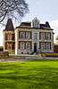 | |
| Eight artificially elevated mounds from the Iron Age (nl) (fr) |
Hamont-Achel | Grote Haart | 51°15′54″N 5°31′15″E / 51.26507°N 5.52079°E | 80084 Info | 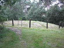 | ||
| Chapel of Our Lady of Peace (nl) (fr) |
Hamont-Achel | Klein Bien | 51°14′40″N 5°28′10″E / 51.24442°N 5.46946°E | 80086 Info | |||
| De Tomp (nl) |
|
Hamont-Achel | Koebroekerweg | 51°16′01″N 5°29′50″E / 51.26685°N 5.49722°E | 80087 Info |  | |
| Parish and St. Monulphus Gondulph (nl) (fr) |
|
Hamont-Achel | Michielsplein | 51°15′17″N 5°28′45″E / 51.25468°N 5.47914°E | 80089 Info | ||
| kiosk (nl) (fr) |
Hamont-Achel | Michielsplein | 51°15′15″N 5°28′45″E / 51.25419°N 5.47903°E | 80090 Info | |||
| Cast iron village pump (nl) (fr) |
Hamont-Achel | Michielsplein | 51°15′11″N 5°28′47″E / 51.25301°N 5.47982°E | 80091 Info | |||
| 'T Mulke <sup style="text-align:right; line-height:1em;
margin-left:0.3em; color:blue; cursor:help; font-family:Verdana,sans-serif;"
title=""'T Mulke"">(nl) |
Hamont-Achel | Molendijk 45 | 51°16′21″N 5°29′55″E / 51.27259°N 5.49865°E | 80092 Info | |||
| Chapel of Our Lady in Distress (nl) (fr) |
Hamont-Achel | Orchideeënlaan | 51°15′12″N 5°29′44″E / 51.25331°N 5.49545°E | 80093 Info | |||
| St. Joseph Chapel (nl) (fr) |
Hamont-Achel | Orchideeënlaan | 51°15′14″N 5°29′08″E / 51.25395°N 5.48545°E | 80094 Info | |||
| Natural stone border marker (nl) |
Hamont-Achel | Orchideeënlaan | 51°15′14″N 5°29′49″E / 51.25377°N 5.49699°E | 80095 Info | |||
| elongated farm "Melskens" <sup style="text-align:right; line-height:1em;
margin-left:0.3em; color:blue; cursor:help; font-family:Verdana,sans-serif;"
title="Langgestrekte hoeve "Melskens"">(nl) |
Hamont-Achel | Oude Baan 30 | 51°15′41″N 5°28′42″E / 51.26130°N 5.47833°E | 80097 Info | |||
| Barn near a modern house (nl) |
Hamont-Achel | Oude Pastorijstraat 32 | 51°15′27″N 5°28′20″E / 51.25754°N 5.47229°E | 80098 Info | |||
| electricity cabin (nl) (fr) |
|
Hamont-Achel | Pastoor Bungenerslaan | 51°15′22″N 5°28′45″E / 51.25619°N 5.47923°E | 80099 Info | ||
| former presbytery (nl) (fr) |
|
Hamont-Achel | Pastoor Bungenerslaan 2 | 51°15′19″N 5°28′47″E / 51.25517°N 5.47961°E | 80100 Info | ||
| Former girls' school and convent of the Sisters Jozefienen (nl) (fr) |
|
Hamont-Achel | Pastoor Bungenerslaan 14 | 51°15′23″N 5°28′47″E / 51.25625°N 5.47961°E | 80101 Info | ||
| elongated farm (nl) (fr) |
Hamont-Achel | Rodenrijt | 51°16′10″N 5°28′10″E / 51.26933°N 5.46932°E | 80102 Info | |||
| "Huis Van Waesberghe" <sup style="text-align:right; line-height:1em;
margin-left:0.3em; color:blue; cursor:help; font-family:Verdana,sans-serif;"
title=""Huis Van Waesberghe"">(nl) |
Hamont-Achel | Schutterijstraat 3 | 51°15′15″N 5°28′41″E / 51.25411°N 5.47810°E | 80103 Info | |||
| "Finding of Holy Cross" Parish (nl) (fr) |
Hamont-Achel | Sint Odilialaan | 51°16′29″N 5°28′29″E / 51.27468°N 5.47465°E | 80104 Info | |||
| Painted iron boundary marker (nl) (fr) |
Hamont-Achel | Sint Odilialaan | 51°17′17″N 5°28′12″E / 51.28818°N 5.47013°E | 80105 Info | |||
| Old house Ceelen (nl) (fr) |
Hamont-Achel | Thomas Watsonlaan 4 | 51°15′03″N 5°28′46″E / 51.25092°N 5.47931°E | 80106 Info | |||
| Old house Ceelen (nl) (fr) |
Hamont-Achel | Thomas Watsonlaan 6 | 51°15′03″N 5°28′46″E / 51.25092°N 5.47931°E | 80106 Info | |||
| Single residential house (nl) (fr) |
Hamont-Achel | Thomas Watsonlaan 32 | 51°14′57″N 5°28′48″E / 51.24927°N 5.47994°E | 80107 Info | |||
| Former weigh house (nl) |
Hamont-Achel | Wagerdijk | 51°16′00″N 5°30′22″E / 51.26662°N 5.50615°E | 80108 Info | |||
| Single elongated farm (nl) (fr) |
Hamont-Achel | Witteberg 14 | 51°15′35″N 5°28′00″E / 51.25980°N 5.46659°E | 80109 Info | |||
| elongated farm (nl) (fr) |
Hamont-Achel | Eind 68 | 51°16′01″N 5°28′36″E / 51.26681°N 5.47653°E | 80110 Info | |||
| Single residential house (nl) (fr) |
|
Hamont-Achel | Generaal Dempseylaan 10 | 51°15′24″N 5°28′44″E / 51.25677°N 5.47889°E | 80111 Info |
See also
| Wikimedia Commons has media related to Onroerend erfgoed in Hamont-Achel. |