| [3] |
Name on the Register |
Image |
Date listed[4] |
Location |
City or town |
Description |
|---|
| 1 |
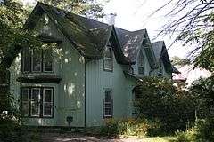
Lyman P. Akins House |
Upload image |
000000001984-07-02-0000July 2, 1984
(#84003067) |
W. Creek Rd.
42°18′53″N 76°14′56″W / 42.314722°N 76.248889°W / 42.314722; -76.248889 (Lyman P. Akins House) |
Berkshire |
|
| 2 |
Robert Akins House |
Upload image |
000000001984-07-02-0000July 2, 1984
(#84003069) |
Main St.
42°18′07″N 76°11′17″W / 42.301944°N 76.188056°W / 42.301944; -76.188056 (Robert Akins House) |
Berkshire |
|
| 3 |
J. Ball House |
Upload image |
000000001984-07-02-0000July 2, 1984
(#84003072) |
NY 38
42°17′53″N 76°11′10″W / 42.298056°N 76.186111°W / 42.298056; -76.186111 (J. Ball House) |
Berkshire |
|
| 4 |
Levi Ball House |
Upload image |
000000001984-07-02-0000July 2, 1984
(#84003075) |
NY 38
42°19′31″N 76°10′56″W / 42.325278°N 76.182222°W / 42.325278; -76.182222 (Levi Ball House) |
Berkshire |
|
| 5 |
Stephen Ball House |
Upload image |
000000001984-07-02-0000July 2, 1984
(#84003077) |
Main St.
42°18′04″N 76°11′15″W / 42.301111°N 76.1875°W / 42.301111; -76.1875 (Stephen Ball House) |
Berkshire |
|
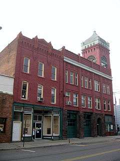
| 6 |
James C. Beecher House |
|
000000002012-07-27-0000July 27, 2012
(#12000482) |
560 5th Ave.
42°06′16″N 76°14′46″W / 42.104416°N 76.246063°W / 42.104416; -76.246063 (James C. Beecher House) |
Owego |
|
| 7 |
Belcher Family Homestead and Farm |
Upload image |
000000001984-07-02-0000July 2, 1984
(#84003082) |
NY 38
42°17′02″N 76°11′18″W / 42.283889°N 76.188333°W / 42.283889; -76.188333 (Belcher Family Homestead and Farm) |
Berkshire |
|
| 8 |
Belcher-Holden Farm |
Upload image |
000000001997-12-15-0000December 15, 1997
(#97001486) |
5825 NY 38
42°11′28″N 76°12′17″W / 42.191111°N 76.204722°W / 42.191111; -76.204722 (Belcher-Holden Farm) |
Newark Valley |
|
| 9 |
Bement-Billings House |
Upload image |
000000001990-02-19-0000February 19, 1990
(#90000002) |
NY 38, N of Newark Valley
42°14′10″N 76°10′45″W / 42.236111°N 76.179167°W / 42.236111; -76.179167 (Bement-Billings House) |
Newark Valley |
|
| 10 |
Berkshire Village Historic District |
Upload image |
000000001984-07-02-0000July 2, 1984
(#84003086) |
Main St. and Leonard Ave.
42°18′22″N 76°11′14″W / 42.306111°N 76.187222°W / 42.306111; -76.187222 (Berkshire Village Historic District) |
Berkshire |
|
| 11 |
Blewer Farm |
Upload image |
000000001998-03-16-0000March 16, 1998
(#98000166) |
184 and 226 Blewer-Mead Rd.
42°11′50″N 76°13′50″W / 42.197222°N 76.230556°W / 42.197222; -76.230556 (Blewer Farm) |
Newark Valley |
|
| 12 |
Calvin A. Buffington House |
Upload image |
000000001984-07-02-0000July 2, 1984
(#84003089) |
Depot St. and Railroad Ave.
42°18′15″N 76°11′05″W / 42.304167°N 76.184722°W / 42.304167; -76.184722 (Calvin A. Buffington House) |
Berkshire |
|
| 13 |
Daniel Chamberlain House |
Upload image |
000000001997-12-15-0000December 15, 1997
(#97001489) |
627 Brown Rd.
42°16′22″N 76°10′28″W / 42.272778°N 76.174444°W / 42.272778; -76.174444 (Daniel Chamberlain House) |
Newark Valley |
|
| 14 |
Morris Clinton House |
Upload image |
000000001998-03-16-0000March 16, 1998
(#98000162) |
225 Zimmer Rd.
42°12′41″N 76°10′49″W / 42.211389°N 76.180278°W / 42.211389; -76.180278 (Morris Clinton House) |
Newark Valley |
|
| 15 |
Nathaniel Bishop Collins House |
Upload image |
000000001984-07-02-0000July 2, 1984
(#84003096) |
NY 38
42°18′40″N 76°11′04″W / 42.311111°N 76.184444°W / 42.311111; -76.184444 (Nathaniel Bishop Collins House) |
Berkshire |
|
| 16 |
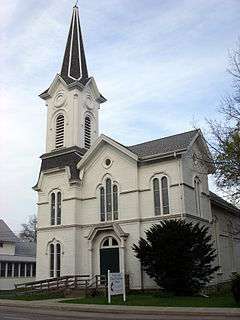
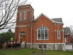
East Berkshire United Methodist Church |
Upload image |
000000001984-07-02-0000July 2, 1984
(#84003098) |
E. Berkshire Rd.
42°18′24″N 76°08′42″W / 42.306667°N 76.145°W / 42.306667; -76.145 (East Berkshire United Methodist Church) |
Berkshire |
|
| 17 |
Evergreen Cemetery |
|
000000002002-04-01-0000April 1, 2002
(#02000305) |
East Ave., bet. Erie St. and Prospect St.
42°06′26″N 76°15′55″W / 42.107222°N 76.265278°W / 42.107222; -76.265278 (Evergreen Cemetery) |
Owego |
|
| 18 |
Farrand-Pierson House |
Upload image |
000000001997-12-15-0000December 15, 1997
(#97001490) |
441 Brown Rd.
42°16′10″N 76°10′27″W / 42.269444°N 76.174167°W / 42.269444; -76.174167 (Farrand-Pierson House) |
Newark Valley |
|
| 19 |
First Congregational Church |
Upload image |
000000001984-07-02-0000July 2, 1984
(#84003101) |
Main St.
42°18′06″N 76°11′18″W / 42.301667°N 76.188333°W / 42.301667; -76.188333 (First Congregational Church) |
Berkshire |
|
| 20 |
First Methodist Episcopal Church of Tioga Center |
|
000000002002-04-01-0000April 1, 2002
(#02000304) |
NY 17C
42°05′02″N 76°20′53″W / 42.083889°N 76.348056°W / 42.083889; -76.348056 (First Methodist Episcopal Church of Tioga Center) |
Tioga Center |
|
| 21 |
First Presbyterian Church |
|
000000002005-12-07-0000December 7, 2005
(#05001392) |
75-77 N. Main St.
42°12′50″N 76°29′33″W / 42.213889°N 76.4925°W / 42.213889; -76.4925 (First Presbyterian Church) |
Spencer |
|
| 22 |
Lebbeus Ford House |
Upload image |
000000001984-07-02-0000July 2, 1984
(#84003104) |
Jewett Hill Rd.
42°18′40″N 76°11′37″W / 42.311111°N 76.193611°W / 42.311111; -76.193611 (Lebbeus Ford House) |
Berkshire |
|
| 23 |
Glenwood Cemetery and Mausoleum |
Upload image |
000000002016-03-08-0000March 8, 2016
(#16000064) |
113 Moore St.
Coordinates missing |
Waverly |
Large 1895 hillside cemetery with 1923 marble mausoleum
|
| 24 |
Grace Episcopal Church |
Upload image |
000000002000-08-02-0000August 2, 2000
(#00000878) |
445 Park Ave.
42°00′13″N 76°32′22″W / 42.003611°N 76.539444°W / 42.003611; -76.539444 (Grace Episcopal Church) |
Waverly |
|
| 25 |
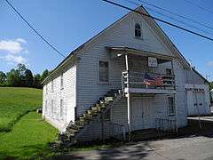
Halsey Valley Grand Army of the Republic Meeting Hall |
|
000000002003-01-23-0000January 23, 2003
(#02001646) |
Hamilton Valley Rd.
42°08′27″N 76°26′28″W / 42.140833°N 76.441111°W / 42.140833; -76.441111 (Halsey Valley Grand Army of the Republic Meeting Hall) |
Spencer |
|
| 26 |
Hiawatha Farm |
|
000000001998-05-20-0000May 20, 1998
(#98000551) |
2293 NY 17C
42°05′30″N 76°12′46″W / 42.091667°N 76.212778°W / 42.091667; -76.212778 (Hiawatha Farm) |
Owego |
|
| 27 |
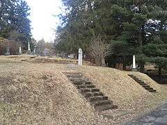
Hope Cemetery and Mausoleum |
Upload image |
000000001998-03-16-0000March 16, 1998
(#98000164) |
Main St., at the town limits
42°12′39″N 76°11′25″W / 42.210833°N 76.190278°W / 42.210833; -76.190278 (Hope Cemetery and Mausoleum) |
Newark Valley |
|
| 28 |
Knapp House |
Upload image |
000000001998-03-16-0000March 16, 1998
(#98000159) |
10 Rock St.
42°13′24″N 76°11′00″W / 42.223333°N 76.183333°W / 42.223333; -76.183333 (Knapp House) |
Newark Valley |
|
| 29 |
Lipe Farm |
Upload image |
000000001998-03-16-0000March 16, 1998
(#98000160) |
3462 Sherry Lipe Rd.
42°11′56″N 76°09′56″W / 42.198889°N 76.165556°W / 42.198889; -76.165556 (Lipe Farm) |
Newark Valley |
|
| 30 |
Maple Lawn Farm |
Upload image |
000000001997-12-15-0000December 15, 1997
(#97001487) |
10981 NY 38
42°15′39″N 76°11′00″W / 42.260833°N 76.183333°W / 42.260833; -76.183333 (Maple Lawn Farm) |
Newark Valley |
|
| 31 |
John W. McCarty House |
Upload image |
000000002001-03-12-0000March 12, 2001
(#01000249) |
118 Main St.
42°13′52″N 76°20′27″W / 42.231111°N 76.340833°W / 42.231111; -76.340833 (John W. McCarty House) |
Candor |
|
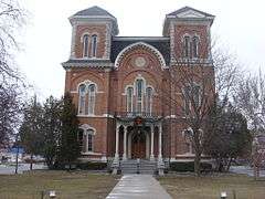
| 32 |
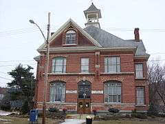
Newark Valley Municipal Building and Tappan-Spaulding Memorial Library |
|
000000002006-11-01-0000November 1, 2006
(#06000971) |
9 Park St. and 8 Rock St.
42°13′25″N 76°11′02″W / 42.223611°N 76.183889°W / 42.223611; -76.183889 (Newark Valley Municipal Building and Tappan-Spaulding Memorial Library) |
Newark Valley |
|
| 33 |
Nichols High School |
Upload image |
000000001996-05-16-0000May 16, 1996
(#96000553) |
84 Cady Ave.
42°01′14″N 76°21′54″W / 42.020556°N 76.365°W / 42.020556; -76.365 (Nichols High School) |
Nichols |
|
| 34 |
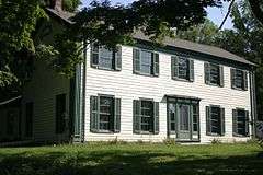
Nowland House |
Upload image |
000000001997-12-15-0000December 15, 1997
(#97001488) |
88 S. Main St.
42°13′10″N 76°11′14″W / 42.219444°N 76.187222°W / 42.219444; -76.187222 (Nowland House) |
Newark Valley |
|
| 35 |
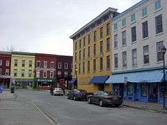
Owego Central Historic District |
|
000000001980-12-03-0000December 3, 1980
((original)
98000353 (increase) #80002780 (original)
98000353 (increase)) |
North Ave., Park, Main, Lake, Court, and Fronts Sts.
42°06′06″N 76°15′40″W / 42.101667°N 76.261111°W / 42.101667; -76.261111 (Owego Central Historic District) |
Owego |
|
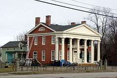
| 36 |
Platt-Cady Mansion |
|
000000001976-08-13-0000August 13, 1976
(#76001286) |
18 River St.
42°01′19″N 76°22′00″W / 42.021944°N 76.366667°W / 42.021944; -76.366667 (Platt-Cady Mansion) |
Nichols |
|
| 37 |
Gilbert E. Purple House |
Upload image |
000000002004-09-15-0000September 15, 2004
(#04000992) |
34 Maple Ave.
42°13′36″N 76°11′20″W / 42.226667°N 76.188889°W / 42.226667; -76.188889 (Gilbert E. Purple House) |
Newark Valley |
|
| 38 |
Riverside Cemetery |
Upload image |
000000002014-01-15-0000January 15, 2014
(#13001093) |
Marshland Rd.
42°05′08″N 76°09′34″W / 42.085547651095375°N 76.15952437791736°W / 42.085547651095375; -76.15952437791736 (Riverside Cemetery) |
Apalachin vicinity |
Final resting place of many early settlers of region
|
| 39 |
Deodatus Royce House |
Upload image |
000000001984-07-02-0000July 2, 1984
(#84003109) |
NY 38
42°19′26″N 76°11′02″W / 42.323889°N 76.183889°W / 42.323889; -76.183889 (Deodatus Royce House) |
Berkshire |
|
| 40 |
J. B. Royce House and Farm Complex |
Upload image |
000000001984-07-02-0000July 2, 1984
(#84003111) |
NY 38
42°19′42″N 76°10′46″W / 42.328333°N 76.179444°W / 42.328333; -76.179444 (J. B. Royce House and Farm Complex) |
Berkshire |
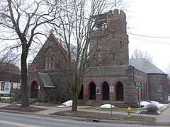
|
| 41 |
St. Paul's Church |
|
000000001997-10-16-0000October 16, 1997
(#97001204) |
117 Main St.
42°06′09″N 76°15′55″W / 42.1025°N 76.265278°W / 42.1025; -76.265278 (St. Paul's Church) |
Owego |
|
| 42 |
John Settle Farm |
Upload image |
000000001998-03-16-0000March 16, 1998
(#98000161) |
1054 Settle Rd.
42°12′31″N 76°07′44″W / 42.208611°N 76.128889°W / 42.208611; -76.128889 (John Settle Farm) |
Newark Valley |
|
| 43 |
Silk Street Bridge |
Upload image |
000000001998-04-30-0000April 30, 1998
(#98000430) |
Silk St., over E Branch of Owego Cr.
42°13′03″N 76°11′38″W / 42.2175°N 76.193889°W / 42.2175; -76.193889 (Silk Street Bridge) |
Newark Valley |
|
| 44 |
Sutton-Chapman-Howland House |
Upload image |
000000001997-12-15-0000December 15, 1997
(#97001492) |
55 Main St.
42°16′22″N 76°10′28″W / 42.272778°N 76.174444°W / 42.272778; -76.174444 (Sutton-Chapman-Howland House) |
Newark Valley |
|
| 45 |
Tioga Centre General Store |
|
000000002003-01-15-0000January 15, 2003
(#02001709) |
3019 NY 17C
42°03′25″N 76°20′53″W / 42.056944°N 76.348056°W / 42.056944; -76.348056 (Tioga Centre General Store) |
Tioga Center |
|
| 46 |
Tioga County Courthouse |
|
000000001972-12-26-0000December 26, 1972
(#72000915) |
Village Park
42°06′09″N 76°15′45″W / 42.1025°N 76.2625°W / 42.1025; -76.2625 (Tioga County Courthouse) |
Owego |
|
| 47 |
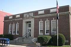
US Post Office-Owego |
|
000000001989-05-11-0000May 11, 1989
(#88002391) |
6 Lake St.
42°06′10″N 76°15′41″W / 42.102778°N 76.261389°W / 42.102778; -76.261389 (US Post Office-Owego) |
Owego |
|
| 48 |
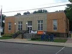
US Post Office-Waverly |
|
000000001989-05-11-0000May 11, 1989
(#88002444) |
434-348 Waverly St.
42°00′07″N 76°32′26″W / 42.001944°N 76.540556°W / 42.001944; -76.540556 (US Post Office-Waverly) |
Waverly |
|
| 49 |
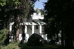
Vesper Cliff |
|
000000002005-07-29-0000July 29, 2005
(#05000746) |
Outside Village of Owego, W bank of Owego Creek, off NY 17
42°05′54″N 76°16′45″W / 42.098333°N 76.279167°W / 42.098333; -76.279167 (Vesper Cliff) |
Owego |
|
| 50 |
Wade Farm |
Upload image |
000000001997-12-15-0000December 15, 1997
(#97001491) |
5579 NY 38
42°11′17″N 76°12′34″W / 42.188056°N 76.209444°W / 42.188056; -76.209444 (Wade Farm) |
Newark Valley |
|
| 51 |
Waits Methodist Episcopal Church and Cemetery |
|
000000002000-11-20-0000November 20, 2000
(#00001290) |
Waite Rd.
42°00′27″N 76°16′08″W / 42.0075°N 76.268889°W / 42.0075; -76.268889 (Waits Methodist Episcopal Church and Cemetery) |
Owego |
|
| 52 |
Waverly Junior and Senior High School |
Upload image |
000000001997-11-07-0000November 7, 1997
(#97001389) |
443 Pennsylvania Ave.
42°00′14″N 76°32′18″W / 42.003889°N 76.538333°W / 42.003889; -76.538333 (Waverly Junior and Senior High School) |
Waverly |
|
| 53 |
Waverly Village Hall |
|
000000002003-07-05-0000July 5, 2003
(#03000600) |
358-360 Broad St.
42°00′03″N 76°32′22″W / 42.000833°N 76.539444°W / 42.000833; -76.539444 (Waverly Village Hall) |
Waverly |
|
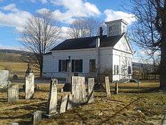
| 54 |
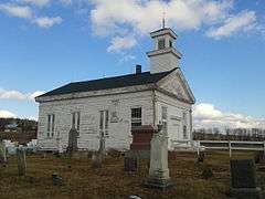
West Newark Congregational Church and Cemetery |
|
000000001998-03-16-0000March 16, 1998
(#98000165) |
Jct. of W. Creek Rd. and W. Newark Cross Rd.
42°14′32″N 76°14′09″W / 42.242222°N 76.235833°W / 42.242222; -76.235833 (West Newark Congregational Church and Cemetery) |
Newark Valley |
|
| 55 |
West Newark School House |
Upload image |
000000001998-03-16-0000March 16, 1998
(#98000163) |
Jct. of W. Creek Rd. and W. Newark Cross Rd.
42°14′30″N 76°14′12″W / 42.241667°N 76.236667°W / 42.241667; -76.236667 (West Newark School House) |
Newark Valley |
|