National Register of Historic Places listings in Saratoga County, New York

Location of Saratoga County in New York
List of the National Register of Historic Places listings in Saratoga County, New York
This is intended to be a complete list of properties and districts listed on the National Register of Historic Places in Saratoga County, New York. The locations of National Register properties and districts (at least for all showing latitude and longitude coordinates below) may be seen in a map by clicking on "Map of all coordinates".[1] Three of the properties and districts are further designated U.S. National Historic Landmarks.
- This National Park Service list is complete through NPS recent listings posted December 16, 2016.[2]
| Albany (Albany) – Allegany – Bronx – Broome – Cattaraugus – Cayuga – Chautauqua – Chemung – Chenango – Clinton – Columbia – Cortland – Delaware – Dutchess (Poughkeepsie, Rhinebeck) – Erie (Buffalo) – Essex – Franklin – Fulton – Genesee – Greene – Hamilton – Herkimer – Jefferson – Kings – Lewis – Livingston – Madison – Monroe (Rochester) – Montgomery – Nassau – New York (Below 14th Street, 14th to 59th Streets, 59th to 110th Streets, Above 110th Street, Islands) – Niagara – Oneida – Onondaga (Syracuse) – Ontario – Orange – Orleans – Oswego – Otsego – Putnam – Queens – Rensselaer – Richmond – Rockland – St. Lawrence – Saratoga – Schenectady – Schoharie – Schuyler – Seneca – Steuben – Suffolk – Sullivan – Tioga – Tompkins – Ulster – Warren – Washington – Wayne – Westchester (Northern, Southern, New Rochelle, Peekskill, Yonkers) – Wyoming – Yates |
Listings county-wide
| [3] | Name on the Register | Image | Date listed[4] | Location | City or town | Description |
|---|---|---|---|---|---|---|
| 1 | Arrowhead Casino Prehistoric Site | 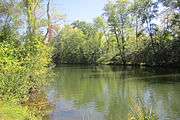 |
(#00000418) |
Address Restricted |
Saratoga Springs | Native American site dating back as far as 8,000-9,000 years ago. |
| 2 | Barker General Store | 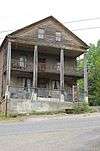 |
(#02000303) |
1 Military Rd. 43°13′18″N 74°06′16″W / 43.221667°N 74.104444°W |
Beecher Hollow | Historic general store constructed in 1847 |
| 3 | Batchellerville Presbyterian Church | Upload image | (#00000578) |
County Route 7 43°12′33″N 74°03′21″W / 43.209167°N 74.055833°W |
Batchellerville | Greek Revival Presbyterian church built in 1867. |
| 4 | Eli and Diadama Beecher House | Upload image | (#15000924) |
2 Military Road 43°13′17″N 74°06′18″W / 43.221448°N 74.1049767°W |
Beecher Hollow | 1830 frame house of settlers who gave their name to surrounding hamlet of Beecher Hollow used as post office at one point |
| 5 | Col. Sidney Berry House | 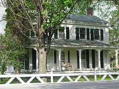 |
(#03001281) |
725 W. River Rd. 43°12′46″N 73°35′08″W / 43.212778°N 73.585556°W |
Northumberland | Historic house built about 1800. |
| 6 | Abraham Best House | 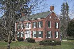 |
(#11000452) |
113 Vischer Ferry Rd. 42°48′44″N 73°49′34″W / 42.812222°N 73.826111°W |
Vischer Ferry | Federal style house, built ca. 1815. |
| 7 | Broadway Historic District | 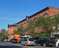 |
(#79001627) |
Originally on Broadway, Washington and Rock Sts., later increased 43°05′12″N 73°47′01″W / 43.086667°N 73.783611°W |
Saratoga Springs | Commercial and residential core of city, with many buildings intact from 19th century |
| 8 | Brookside | 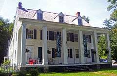 |
(#75001223) |
Charlton St. 43°00′07″N 73°51′22″W / 43.001944°N 73.856111°W |
Ballston Spa | 1793 house, modified later, was first built at springs for travelers. James Fenimore Cooper wrote part of Last of the Mohicans there. Now home to county historical society. |
| 9 | Bullard Block | 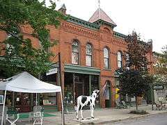 |
(#09000723) |
90-98 Broad St. 43°05′56″N 73°34′54″W / 43.098958°N 73.581675°W |
Schuylerville | Commercial building built in 1881 in the High Victorian Gothic style. |
| 10 | Canfield Casino and Congress Park | 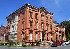 |
(#72000910) |
Roughly bounded by Spring and Circular Sts., Park Pl., and Broadway 43°04′41″N 73°47′05″W / 43.078056°N 73.784722°W |
Saratoga Springs | Site of early bottling plant and hotel now used as public park and history museum. Designated a National Historic Landmark District on February 27, 1987. |
| 11 | Catawissa (tugboat) | Upload image | (#96000828) |
Lock 3, New York State Barge Canal, Erie Division 42°47′57″N 73°41′22″W / 42.799167°N 73.689444°W |
Waterford | Tugboat built in 1896-1897 and scrapped in 2008. |
| 12 | Champlain Canal |  |
(#76001274) |
Extends north from Troy to Whitehall 43°10′00″N 73°33′24″W / 43.166667°N 73.556667°W |
Troy | 60-mile (97 km) canal connecting the south end of Lake Champlain to the Hudson River in New York constructed simultaneously with the Erie Canal. |
| 13 | Charlton Historic District | 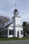 |
(#76001271) |
Main St. (NY 51) 42°56′02″N 73°57′55″W / 42.933889°N 73.965278°W |
Charlton | 123-acre (50 ha) district at the hamlet of Charlton. Includes 37 contributing buildings dating to 1787 and includes notable Greek Revival and Italianate architecture. |
| 14 | Clifton Park Center Baptist Church and Cemetery | 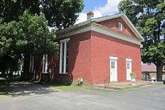 |
(#04001055) |
713 Clifton Park Center Rd. 42°51′31″N 73°49′55″W / 42.858611°N 73.831944°W |
Clifton Park Center | Baptist church and cemetery built in 1837. |
| 15 | Clifton Park Hotel | 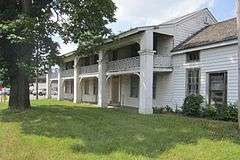 |
(#98000705) |
Old NY 146 and US 9 42°51′57″N 73°46′15″W / 42.865833°N 73.770833°W |
Clifton Park and Halfmoon | Historic hotel erected in the 1820s. |
| 16 | Copeland Covered Bridge | 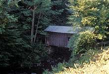 |
(#98000998) |
North Shore Rd., over Beecher Creek 43°13′15″N 74°06′02″W / 43.220833°N 74.100556°W |
Edinburg | Wooden covered bridge |
| 17 | Crescent Methodist Episcopal Church | Upload image | (#00000091) |
Crescent 42°49′29″N 73°43′53″W / 42.824722°N 73.731389°W |
Crescent | Methodist Episcopal church, built in 1852 and demolished sometime before 2013. |
| 18 | The Drinkhall | 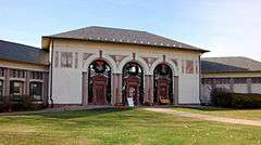 |
(#74001302) |
297 Broadway 43°05′06″N 73°47′45″W / 43.085°N 73.795833°W |
Saratoga Springs | Historic trolley station built in 1915 by the Hudson Valley Railroad. |
| 19 | Dunning Street Cemetery |  |
(#15000033) |
Dunning Street 42°58′17″N 73°47′44″W / 42.971497°N 73.795488°W |
Malta | Final resting place of many important early Malta residents, including veterans of Revolutionary War, since 1775 |
| 20 | Dutch Reformed Church of Gansevoort | Upload image | (#94001568) |
10 Catherine St. 43°11′56″N 73°39′06″W / 43.198889°N 73.651667°W |
Gansevoort | Dutch Reformed church, built about 1840 and demolished 1996. |
| 21 | East Side Historic District | 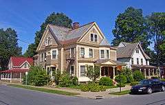 |
(#82001267) |
Roughly bounded by George, Henry, East, and North Sts. 43°04′49″N 73°46′41″W / 43.080278°N 73.778056°W |
Saratoga Springs | Intact residential area of well-to-do 19th century residents east of downtown. |
| 22 | Col. Elmer E. Ellsworth Monument and Grave | 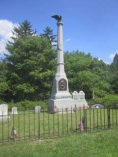 |
(#76001273) |
Hudson View Cemetery 42°53′53″N 73°41′32″W / 42.898056°N 73.692222°W |
Mechanicville | Monument to Elmer E. Ellsworth, the first casualty of the American Civil War, built in 1874. |
| 23 | Franklin Square Historic District |  |
(#73001264) |
In an irregular pattern from Beekman St. along both sides of Grand Ave., Franklin, and Clinton Sts. to Van Dam 43°04′58″N 73°47′25″W / 43.082778°N 73.790278°W |
Saratoga Springs | Upscale area of Greek Revival housing later incorporated into West Side Historic District |
| 24 | Gansevoort Mansion | 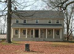 |
(#76001272) |
Off NY 32 43°11′48″N 73°39′13″W / 43.196667°N 73.653611°W |
Gansevoort | House built in 1813 by Herman Gansevoort (1779–1862). |
| 25 | Nathan Garnsey House | 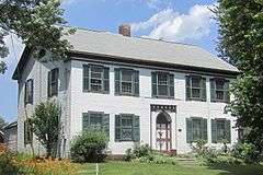 |
(#11001025) |
1453 NY 146 42°52′07″N 73°51′57″W / 42.868742°N 73.865961°W |
Rexford | Unaltered example of Federal architecture, ca. 1791. |
| 26 | Gideon Putnam Burying Ground | 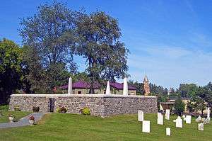 |
(#03001279) |
Franklin St. 43°04′42″N 73°47′30″W / 43.078333°N 73.791667°W |
Saratoga Springs | Early graveyard contains grave of city founder and his family. Only trace of him on the city's West Side. |
| 27 | Grant Cottage | 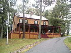 |
(#71000557) |
CR 101 north of US 9 43°12′03″N 73°44′45″W / 43.200833°N 73.745833°W |
Mount McGregor | Cottage first owned by banker Joseph W. Drexel. It was the site where Ulysses S. Grant died in 1885. |
| 28 | Grooms Tavern Complex | 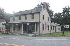 |
(#00000094) |
Sugar Hill Rd. at Grooms Rd. 42°50′05″N 73°50′41″W / 42.834722°N 73.844722°W |
Grooms Corners | Historic tavern located at Grooms Corners. The complex consists of the 1825 tavern, a wagon and blacksmith shop, and a frame privy. |
| 29 | Hadley Mountain Fire Observation Station | Upload image | (#01001037) |
Hadley Mountain 43°22′26″N 73°57′03″W / 43.373889°N 73.950833°W |
Hadley | Historic fire observation station built in 1917. |
| 30 | Hadley Parabolic Bridge | 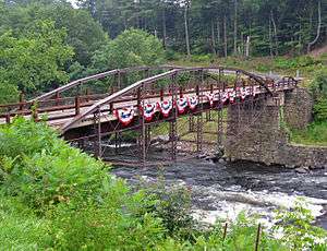 |
(#77000981) |
CR 1 43°18′50″N 73°50′44″W / 43.313889°N 73.845556°W |
Hadley | Built in 1895. Only iron semi-deck lenticular truss bridge extant in state. |
| 31 | Jonesville Cemetery | 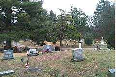 |
(#14000132) |
Ushers & Longkill Rds. 42°54′34″N 73°49′17″W / 42.909449°N 73.821259°W |
Jonesville | |
| 32 | Jonesville Store | 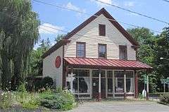 |
(#10001136) |
989 Main St. 42°54′37″N 73°49′24″W / 42.910278°N 73.823333°W |
Jonesville | Country store at Main Street and Longkill Road; now vacant. |
| 33 | Marshall House | Upload image | (#02000878) |
136 NY 32 North 43°06′40″N 73°34′50″W / 43.111111°N 73.580556°W |
Schuylerville | Farmhouse constructed in 1770–1773 used by the British as a field hospital during the Battles of Saratoga. |
| 34 | Mead House | Upload image | (#04000433) |
2210 Galway Rd. 43°00′57″N 74°01′20″W / 43.015833°N 74.022222°W |
Galway | House built about 1825. |
| 35 | Mechanicville Hydroelectric Plant |  |
(#89001942) |
At NY 32 on the Hudson River 42°52′41″N 73°40′47″W / 42.878056°N 73.679722°W |
Mechanicville | Powerhouse, earth embankment, concrete non-overflow dam, and 700 feet long concrete gravity overflow dam built in 1897-1898. |
| 36 | Mohawk Valley Grange Hall | 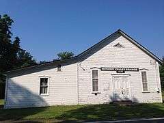 |
(#12000245) |
274 Sugar Hill Rd. 42°50′00″N 73°50′37″W / 42.833398°N 73.843512°W |
Grooms Corners | Grange hall built in 1791. |
| 37 | New York State Barge Canal | .jpg) |
(#14000860) |
Linear across county, along Mohawk River and Champlain Canal Coordinates missing |
Clifton Park, Halfmoon, Mechanicville, Moreau, Northumberland, Saratoga, Schuylerville, Stillwater, Waterford | Successor to Erie Canal approved by state voters in early 20th century to compete with railroads |
| 38 | Northside Historic District | 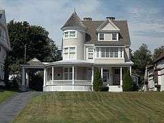 |
(#75001226) |
Both sides of Saratoga Ave. (NY 32) from Maple Ave. to Roosevelt Bridge 42°47′06″N 73°41′34″W / 42.785°N 73.692778°W |
Waterford | District dating to 1828 characterized by large and small structures including the mansions of mill owners and modest workers' dwellings. |
| 39 | Noxon Bank Building | 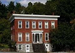 |
(#03001247) |
9 Terminal Rd. 42°49′25″N 73°43′58″W / 42.823611°N 73.732778°W |
Crescent | Bank built in 1842. |
| 40 | Oakcliff | 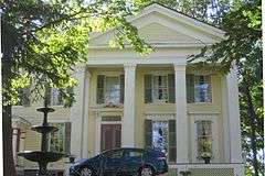 |
(#98000548) |
78 Church Hill Rd. 42°49′28″N 73°43′49″W / 42.824444°N 73.730278°W |
Crescent | Historic house built about 1840. |
| 41 | Ormsby-Laughlin Textile Companies Mill | 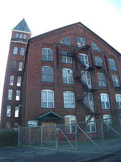 |
(#86000470) |
31 Mohawk Ave. 42°47′18″N 73°41′00″W / 42.788333°N 73.683333°W |
Waterford | Textile mill built circa 1894; it is the only surviving factory associated with the major industrial community known as Dial City. |
| 42 | Parks-Bentley House | Upload image | (#94000331) |
53 Ferry Blvd. 43°18′00″N 73°37′27″W / 43.3°N 73.624167°W |
South Glens Falls | House in built about 1840. |
| 43 | Packer Farm and Barkersville Store | Upload image | (#13000630) |
7189 Barkersville Rd. 43°05′22″N 74°02′28″W / 43.0893383°N 74.0410594°W |
Middle Grove | Mid-19th century house moved to property and store built later are excellent examples of local vernacular architecture from the periods. |
| 44 | Peebles (Peobles) Island | 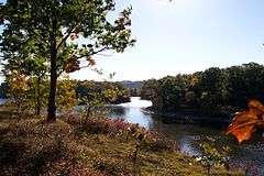 |
(#73001265) |
At junction of the Mohawk and Hudson Rivers 42°46′53″N 73°41′12″W / 42.781389°N 73.686667°W |
Waterford | |
| 45 | Petrified Sea Gardens | 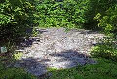 |
(#99000631) |
42 Petrified Gardens Road 43°04′59″N 73°50′40″W / 43.083056°N 73.844444°W |
Saratoga Springs | Site of discovery of stromatolites; New York State Paleontologist Winifred Goldring, a pioneering 19th-century woman in science, researched them extensively here. |
| 46 | Pure Oil Gas Station | 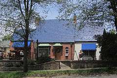 |
(#78001905) |
65 Spring St. 43°04′45″N 73°46′57″W / 43.079167°N 73.7825°W |
Saratoga Springs | Moved from Broadway to this address and adapted for reuse as a restaurant |
| 47 | David Rayfiel House | Upload image | (#09000910) |
1266 Kathan Rd. 43°18′01″N 73°56′31″W / 43.300144°N 73.942019°W |
Day | Modern Movement style house built in 1958. |
| 48 | Cyrus Rexford House | 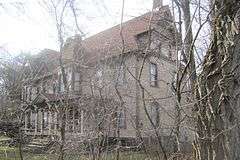 |
(#10001135) |
1643 NY 146 42°51′20″N 73°53′21″W / 42.855556°N 73.889167°W |
Rexford | Stick Style Victorian house built in 1883. |
| 49 | Round Lake Historic District | 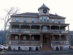 |
(#75001225) |
U.S. Route 9 42°56′14″N 73°47′41″W / 42.937222°N 73.794722°W |
Round Lake | Notable collection of late 19th century structures which are remarkably homogeneous. |
| 50 | The Royal Blockhouse | Upload image | (#11001062) |
Address Restricted |
Moreau | British fortification that was part of the Fort Edward/Rogers Island military complex during the French and Indian War. |
| 51 | Ruhle Road Lenticular Metal Truss Bridge |  |
(#04000954) |
Ruhle Rd over Ballston Creek 42°57′30″N 73°49′00″W / 42.958439°N 73.816719°W |
Malta | Lenticular truss bridge constructed in 1888 to span Black Creek in Salem |
| 52 | St. Stephen's Episcopal Church | 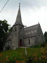 |
(#05000264) |
1 Grove St. 43°05′48″N 73°35′02″W / 43.096667°N 73.583889°W |
Schuylerville | Gothic Revival style Episcopal church built in 1868. |
| 53 | Saratoga Gas, Electric Light and Power Company Complex | .jpg) |
(#00000579) |
Excelsior Ave. 43°05′24″N 73°46′32″W / 43.09°N 73.775556°W |
Saratoga Springs | Two buildings remain from early gas-generating power station started in 1873. Site also has archeological evidence of other buildings. |
| 54 | Saratoga National Historical Park |  |
(#66000569) |
30 miles (48 km) north of Albany via U.S. 4 and NY 32 42°59′24″N 73°38′02″W / 42.99°N 73.633889°W |
Saratoga | The park preserves the site of the Battles of Saratoga, the first significant American military victory of the American Revolutionary War in 1777. |
| 55 | Old Saratoga Reformed Church | 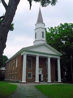 |
(#97001387) |
Junction of Burgoyne and Pearl Sts. 43°05′54″N 73°35′05″W / 43.098333°N 73.584722°W |
Schuylerville | Reformed Church in America church built in 1857 in the Greek Revival style. |
| 56 | Saratoga Spa State Park District |  |
(#85002357) |
US 9 & NY 50 43°03′20″N 73°48′01″W / 43.055556°N 73.800278°W |
Saratoga Springs | Renowned springs over only geysers in eastern U.S. made Saratoga a famous and popular resort |
| 57 | Smith's Grain and Feed Store | 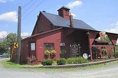 |
(#12000260) |
857 Main St. 42°53′35″N 73°49′16″W / 42.893165°N 73.821239°W |
Elnora | Coal yard and grain business of George Smith at Elnora railroad crossing. |
| 58 | Stillwater United Church | 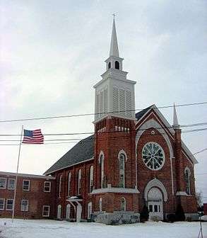 |
(#06000887) |
135 Hudson Ave. 42°56′20″N 73°39′15″W / 42.938889°N 73.654167°W |
Stillwater | Historic church designed by noted architect Marcus F. Cummings and built in 1873. |
| 59 | Hiram Charles Todd House | 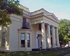 |
(#72000911) |
4 Franklin Sq. 43°04′57″N 73°47′23″W / 43.0825°N 73.789722°W |
Saratoga Springs | 1837 Greek Revival house near former site of railroad station |
| 60 | Union Avenue Historic District | 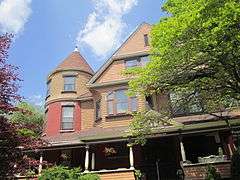 |
(#78001906) |
Union Ave. 43°04′16″N 73°45′56″W / 43.071111°N 73.765556°W |
Saratoga Springs | Union Avenue includes a number of stately Victorian houses built in the second half of the nineteenth and early twentieth centuries. |
| 61 | Union Mill Complex | 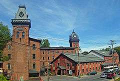 |
(#82003404) |
NY 50, Milton Ave. 43°00′33″N 73°51′04″W / 43.009167°N 73.851111°W |
Ballston Spa | Center of George West's paper-bag–making business. Later a chocolate factory and today a retail complex. |
| 62 | URGER (canal tugboat) | _01.jpg) |
(#01001320) |
Near the eastern terminus of the Erie Division of the New York State Barge Canal 42°47′47″N 73°41′15″W / 42.796389°N 73.6875°W |
Waterford | Historic canal tugboat built in 1901. |
| 63 | US Post Office-Ballston Spa | 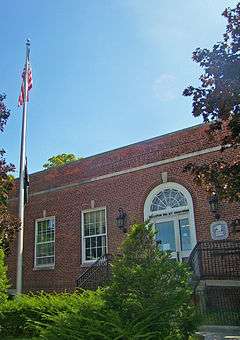 |
(#88002468) |
1 Front St. 43°00′08″N 73°50′58″W / 43.002222°N 73.849444°W |
Ballston Spa | 1936 building in extremely restrained Colonial Revival style is like only one other post office in state |
| 64 | US Post Office-Saratoga Springs | 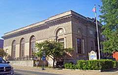 |
(#88002427) |
475 Broadway 43°05′00″N 73°47′08″W / 43.083333°N 73.785556°W |
Saratoga Springs | Ornate 1910 Classical Revival building once had most elaborate postal lobby in state |
| 65 | Verbeck House | 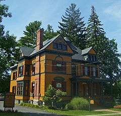 |
(#83001790) |
20 Church Ave. 43°00′01″N 73°50′59″W / 43.000278°N 73.849722°W |
Ballston Spa | Rare late residence by Marcus F. Cummings. Later used as National Bottle Museum. |
| 66 | Victory Mills | 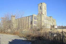 |
(#09001271) |
42 Gates Ave. 43°05′21″N 73°35′31″W / 43.089083°N 73.591883°W |
Victory | Historic textile mill building built in 1918. |
| 67 | Vischer Ferry Historic District | 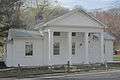 |
(#75001224) |
Southwest of Clifton Park at the junction of River View, Vischer Ferry, and Crescent Rds. 42°47′41″N 73°49′12″W / 42.794722°N 73.82°W |
Clifton Park | Located along the Erie Canal, the district contains several historic structures including the Nicholas and Eldret Vischer House, dating from the mid-1700s. |
| 68 | Waterford Village Historic District | 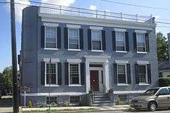 |
(#77000982) |
Roughly bounded by the Hudson River, Erie Canal, and State St. 42°47′26″N 73°40′46″W / 42.790556°N 73.679444°W |
Waterford | The district dates to 1799 and includes Greek Revival, Late Victorian and Federal architecture. |
| 69 | West Charlton United Presbyterian Church | 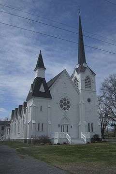 |
(#98000127) |
1331 Sacandaga Rd. 42°58′22″N 74°01′50″W / 42.972778°N 74.030556°W |
West Charlton | Presbyterian church built about 1880 by immigrants from Scotland. |
| 70 | West Side Historic District | 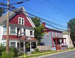 |
(#94000258) |
Roughly, along Church, Van Dam, State and Washington Sts., Woodlawn and Grand Aves. and Franklin Sq. 43°05′13″N 73°47′08″W / 43.086944°N 73.785556°W |
Saratoga Springs | Large intact residential area of working-class housing from 19th century |
| 71 | George West House | 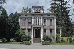 |
(#05000312) |
801 NY 29 43°03′59″N 73°55′38″W / 43.066389°N 73.927222°W |
Rock City Falls | Former home of industrialist and congressman George West |
| 72 | Wiggins-Collamer House | 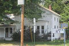 |
(#07001127) |
450 E. High St. 42°59′47″N 73°47′28″W / 42.996389°N 73.791111°W |
Malta | Historic house built about 1835. |
| 73 | Yaddo | .jpg) |
(#13000282) |
63 Henning Rd. 43°04′05″N 73°45′29″W / 43.068°N 73.758°W |
Saratoga Springs | Former house of financier Spencer Trask and his wife, the writer Katrina Trask. Now an artists' colony. |
Former listing
| [3] | Name on the Register | Image | Date listed | Date removed | Location | City or town | Summary |
|---|---|---|---|---|---|---|---|
| 1 | Ruhle Road Stone Arch Bridge | 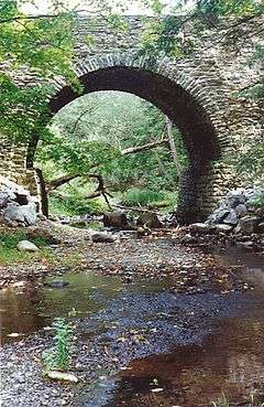 |
(#88001699) | Ruhle Road |
Malta | Historic stone arch bridge in Malta in Saratoga County, New York over Ballston Creek. Constructed about 1873; collapsed in 1993. |
See also
| Wikimedia Commons has media related to National Register of Historic Places in Saratoga County, New York. |
References
- ↑ The latitude and longitude information provided in this table was derived originally from the National Register Information System, which has been found to be fairly accurate for about 99% of listings. For about 1% of NRIS original coordinates, experience has shown that one or both coordinates are typos or otherwise extremely far off; some corrections may have been made. A more subtle problem causes many locations to be off by up to 150 yards, depending on location in the country: most NRIS coordinates were derived from tracing out latitude and longitudes off of USGS topographical quadrant maps created under the North American Datum of 1927, which differs from the current, highly accurate WGS84 GPS system used by most on-line maps. Chicago is about right, but NRIS longitudes in Washington are higher by about 4.5 seconds, and are lower by about 2.0 seconds in Maine. Latitudes differ by about 1.0 second in Florida. Some locations in this table may have been corrected to current GPS standards.
- ↑ "National Register of Historic Places: Weekly List Actions". National Park Service, United States Department of the Interior. Retrieved on December 16, 2016.
- 1 2 Numbers represent an ordering by significant words. Various colorings, defined here, differentiate National Historic Landmarks and historic districts from other NRHP buildings, structures, sites or objects.
- ↑ The eight-digit number below each date is the number assigned to each location in the National Register Information System database, which can be viewed by clicking the number.
| Topics |   | |
|---|---|---|
| Lists by county |
| |
| Lists by city | ||
| Other lists | ||
| ||
This article is issued from Wikipedia - version of the 10/31/2016. The text is available under the Creative Commons Attribution/Share Alike but additional terms may apply for the media files.