Langrick
| Langrick | |
 Langrick Bridge |
|
 Langrick |
|
| OS grid reference | TF263484 |
|---|---|
| – London | 105 mi (169 km) S |
| Civil parish | Langriville |
| District | East Lindsey |
| Shire county | Lincolnshire |
| Region | East Midlands |
| Country | England |
| Sovereign state | United Kingdom |
| Post town | Boston |
| Postcode district | PE22 |
| Police | Lincolnshire |
| Fire | Lincolnshire |
| Ambulance | East Midlands |
| EU Parliament | East Midlands |
| UK Parliament | Boston and Skegness |
|
|
Coordinates: 53°01′00″N 0°07′00″W / 53.01666°N 0.11667°W
Langrick is a small village in the East Lindsey district of Lincolnshire, England. It is situated in the civil parish of Langriville (where the population is included), and on the B1192 road, 5 miles (8 km) north-west from Boston. The village lies in the Lincolnshire Fens, and less than 1 mile (1.6 km) east from the River Witham.
History
The name Langrick appears to come from "Long Creek"[1] and is at the very southern edge of Wildmore Fen, in an area which was once the manor of Armtree, in the parish of Coningsby.[2] It was once the site of a hermitage belonging to Kirkstead Abbey. When Langrick and Langriville were enclosed in 1812 there was not a single house existing.[3] Langrick's importance was that it was the site of a ferry crossing over the River Witham,[3] reputedly built by Robert Dymoke.[2] The river was straightened in 1833.[3]
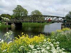
A steel bridge was built just west of the ferry site in 1909[3] and is still in use today.
Church

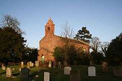
Saint Margaret of Scotland Church was built in 1828,[3] probably by Jeptha Pacey, but was not dedicated until 20 April 1922.[4] It is a Grade II listed building and was restored and altered in 1885.[5] The registers of births and deaths date from 1831, and those of marriages from 1837.[4] The church was restored again and redecorated in 1935, and further work was carried out in 1968.[4]
Today, the church forms part of the Brothertoft Group, in the Diocese of Lincoln, also known as 'Five in the Fen', which also includes:[6]
- St Gilbert of Sempringham, Brothertoft
- All Saints, Holland Fen
- Christ Church, Kirton Holme
- St Peter, Wildmore
Railway station
Langrick railway station was on the now dismantled Great Northern Railway railway line between Lincoln and Boston.[3] A cafe stands on the site of the station master's house and booking office.[7]
The Water Rail Way follows the route of the old dismantled railway line from Lincoln to Boston and can be joined at Langrick.[8]
Near the site of the old railway line is the Ferry Boat Inn public house.[9]
 |
Dogdyke, Coningsby, Woodhall Spa | Thornton le Fen, New York, Tumby | Carrington, Stickney, Skegness |  |
| Holland Fen, South Kyme, Sleaford | |
Frithville, Sibsey, Old Leake | ||
| ||||
| | ||||
| Amber Hill, Heckington, Grantham | Brothertoft, Hubberts Bridge, Swineshead | Anton's Gowt, Boston, Fishtoft |
References
- ↑ Pishey Thompson (1856). The History & Antiquities of Boston. Longman & Co. p. 360. Retrieved 8 February 2012.
- 1 2 Pishey Thompson (1856). The History & Antiquities of Boston. Longman & Co. p. 622. Retrieved 8 February 2012.
- 1 2 3 4 5 6 "Boston UK". Langrick. Visitor uk.com. Retrieved 20 April 2011.
- 1 2 3 "Langriville Parish Council Website". Retrieved 21 April 2011.
- ↑ "St Margaret, Langrick". National Heritage List for England. English Heritage. Retrieved 24 August 2011.
- ↑ "A Church Near You". A Church Near You. Retrieved 26 April 2011.
- ↑ "Langrick". Disused Stations. Subterranea Brittanica. Retrieved 24 August 2011.
- ↑ "Water Rail Way". Sustrans Org. Retrieved 21 April 2011.
- ↑ "Ferry Boat Inn". Information Britain. Retrieved 24 August 2011.
External links
 Media related to Langrick at Wikimedia Commons
- A brief history of Langrick